Key Takeaways
- Core idea: Flood mitigation projects reduce flood risk by lowering flood depth, flow peaks, exposure, damage, or the consequences of flooding.
- Engineering use: Engineers use these projects to protect communities, roads, bridges, utilities, buildings, and flood-prone watersheds.
- What controls it: The best project depends on the flood source, watershed response, design storm, topography, land availability, downstream capacity, and maintenance access.
- Practical check: A mitigation project should be reviewed for residual risk, overflow paths, debris blockage, tailwater, downstream impacts, and long-term operation.
Table of Contents
Introduction
Flood mitigation projects are engineered, planning-based, or nature-based measures that reduce flood risk to people, property, and infrastructure. They do not make flooding impossible; instead, they reduce flood depth, frequency, velocity, exposure, or damage by storing water, conveying it safely, protecting vulnerable areas, or moving risk away from the floodplain.
Types of Flood Mitigation Projects

Start by reading the graphic as three different ways to reduce risk: control water with infrastructure, reduce exposure through policy or property actions, and use landscapes that absorb, slow, or store floodwater.
What Is a Flood Mitigation Project?
A flood mitigation project is a planned action that reduces the likelihood or consequences of flooding. In water resources engineering, that usually means managing how stormwater, river flow, coastal surge, or overbank flooding moves through a watershed and interacts with homes, roads, bridges, utilities, and critical facilities.
The key word is risk. A project may reduce peak flow, lower a flood elevation, store runoff temporarily, keep floodwater away from a neighborhood, elevate a vulnerable structure, restore floodplain storage, or reduce the number of buildings exposed to repeated flooding. A good project is judged by the flood problem it solves, the risk it leaves behind, and whether it can be operated and maintained over time.
Flood mitigation is broader than flood control measures. Flood control often implies physically controlling water with infrastructure, while flood mitigation also includes reducing exposure, changing land use, improving warning and planning, and restoring natural storage.
Structural, Nonstructural, and Nature-Based Project Types
The most useful way to understand flood mitigation projects is to group them by how they reduce risk. Some projects control or redirect water. Others reduce the vulnerability of people and structures. Nature-based projects slow, absorb, store, or spread floodwater across landscapes that are designed to tolerate it.
| Project category | Common project examples | How it reduces flood risk | Engineering caution |
|---|---|---|---|
| Structural flood mitigation | Levees, floodwalls, dams, channels, culvert upgrades, bridge opening improvements, pump stations, detention basins | Controls, conveys, stores, blocks, or redirects floodwater to reduce inundation in a protected area. | Can shift risk downstream or create residual risk if overtopped, undersized, poorly maintained, or blocked by debris. |
| Nonstructural flood mitigation | Home elevation, floodproofing, buyouts, relocation, land-use planning, flood warning, floodplain preservation | Reduces the damage caused by flooding by changing exposure, building vulnerability, or development patterns. | Often depends on public participation, funding eligibility, property constraints, and long-term policy enforcement. |
| Nature-based flood mitigation | Wetland restoration, floodplain reconnection, riparian buffers, bioswales, rain gardens, permeable pavement, green streets | Uses storage, infiltration, roughness, vegetation, and floodplain function to slow runoff and reduce flood peaks. | Performance depends on soils, groundwater, maintenance, available space, vegetation health, and storm size. |
| Hybrid green-gray systems | Detention basin with wetland bench, floodwall with restored floodplain, culvert upgrade with stream restoration, green streets with storm sewer upgrades | Combines engineered capacity with natural storage, water quality, habitat, or peak-flow reduction benefits. | Requires coordination between hydraulic performance, maintenance responsibilities, permitting, and ecological goals. |
Structural projects
Structural projects are physical works that change the movement or storage of floodwater. A levee may keep frequent overbank flows away from a neighborhood, a culvert upgrade may reduce a roadway overtopping problem, and a detention basin may temporarily store runoff so the downstream system receives a lower peak flow.
Nonstructural projects
Nonstructural projects reduce damage without relying only on new flood-control infrastructure. Elevating a building above a flood elevation, acquiring a repetitive-loss property, preserving floodplain land, or guiding development away from high-risk areas can reduce long-term risk even when floodwater still enters the area.
Nature-based projects
Nature-based projects work with the landscape. Wetlands, floodplain reconnection, bioswales, and permeable surfaces can store water, increase infiltration, slow overland flow, and improve water quality. They are especially useful where a project needs both flood reduction and environmental benefits.
Flood Mitigation Project Examples by Problem Type
Searchers often want concrete examples, but the right project depends on the flood mechanism. A neighborhood with shallow street flooding, a river corridor with overbank flooding, and a coastal community with storm surge may all need different mitigation strategies.
| Flood problem | Example mitigation projects | Why the project type fits |
|---|---|---|
| Repetitive residential flooding | Home elevation, dry floodproofing, acquisition, relocation, local drainage correction | These actions reduce exposure when repeatedly flooded buildings are located where preventing floodwater may be difficult or uneconomical. |
| Urban street flooding during intense rainfall | Inlet upgrades, storm drain improvements, detention storage, green streets, bioswales, emergency overflow routes | Urban flooding often depends on inlet capture, pipe capacity, surface flow paths, impervious cover, and short-duration rainfall intensity. |
| River overbank flooding | Floodplain restoration, levees, floodwalls, property acquisition, structure elevation, floodplain preservation | These projects either reduce flood elevation and velocity or move vulnerable assets away from areas that naturally store overbank flow. |
| Undersized roadway crossing | Culvert replacement, bridge opening expansion, channel stabilization, debris management, upstream storage | Increasing conveyance at a crossing can reduce headwater and overtopping, but downstream capacity and erosion must be checked. |
| Coastal, tidal, or compound flooding | Elevation, floodproofing, wetland restoration, tide gates, pump stations, berms, floodwalls, evacuation and warning improvements | Coastal flood risk may combine surge, waves, high tide, rainfall, blocked outfalls, and downstream tailwater. |
| New development increasing runoff | Detention, retention, infiltration practices, low-impact development, floodplain preservation, runoff volume controls | Development changes runoff volume, peak timing, impervious cover, and drainage patterns, so mitigation must compare pre- and post-development conditions. |
These examples also connect to broader flood risk assessment. Before a project is selected, engineers need to understand who or what is at risk, how often flooding occurs, how deep water gets, and what failure or overflow scenario remains after the project is built.
How Flood Mitigation Projects Reduce Risk
Flood mitigation projects reduce risk by changing one or more parts of the flood problem: the amount of runoff leaving a watershed, the timing of the flood peak, the water surface elevation, the velocity of flow, the exposure of people and structures, or the ability of a system to safely overflow without causing unacceptable damage.
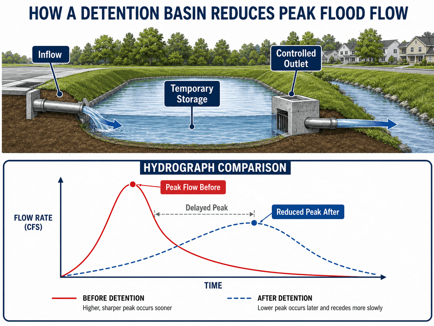
For scanners, the key idea is simple: detention does not make rainfall disappear. It temporarily stores runoff, lowers the downstream peak, delays the hydrograph, and gives the receiving channel or storm drain system more time to pass flow.
Reducing peak flow
Detention basins, wetlands, floodplain storage areas, and distributed green infrastructure can spread runoff over a longer period. That does not necessarily reduce total rainfall volume, but it can reduce the peak flow that reaches a downstream pipe, channel, culvert, or river reach.
Lowering flood depth or water surface elevation
Channel improvements, bridge opening upgrades, culvert replacements, floodwalls, and levees may reduce flood depth at specific locations. These projects require careful hydraulic review because changing conveyance in one reach can affect water surface elevations, velocities, erosion potential, and downstream timing elsewhere.
Reducing exposure
Property elevation, relocation, floodproofing, buyouts, and floodplain preservation reduce the amount of damage that occurs when flooding happens. This is often the most durable strategy for areas that repeatedly flood or where structural protection would be expensive, difficult to maintain, or environmentally disruptive.
Green, Gray, and Hybrid Flood Mitigation
Modern flood mitigation often blends green and gray infrastructure. Gray infrastructure includes engineered systems such as pipes, culverts, pump stations, channels, floodwalls, and levees. Green infrastructure and nature-based solutions use soil, vegetation, wetlands, floodplains, and distributed storage to slow or absorb runoff.
| Approach | Best suited for | Limitations to check |
|---|---|---|
| Green infrastructure | Frequent rainfall, water quality treatment, localized runoff reduction, distributed storage, streetscape retrofits | Soil infiltration, groundwater depth, clogging, vegetation survival, winter performance, and overflow routing. |
| Gray infrastructure | Concentrated flows, bridge and culvert crossings, dense urban areas, pump-dependent systems, defined protection lines | Downstream impacts, failure consequences, capacity exceedance, inspection needs, and structural maintenance. |
| Hybrid systems | Projects that need reliable hydraulic capacity plus storage, water quality, habitat, or public-space benefits | Coordination between civil design, landscape performance, environmental permitting, ownership, and maintenance responsibilities. |
A common hybrid example is a detention basin designed with a wetland bench, sediment forebay, controlled outlet, and emergency spillway. Another is a culvert upgrade paired with streambank stabilization and floodplain reconnection. These systems can reduce peak flow while also improving resilience, water quality, and habitat.
Flood Mitigation Project Selection Workflow
Engineers do not choose a project type just because it is popular or visible. The selection process starts with the flood mechanism and then works through data, modeling, alternatives, constraints, and long-term performance.
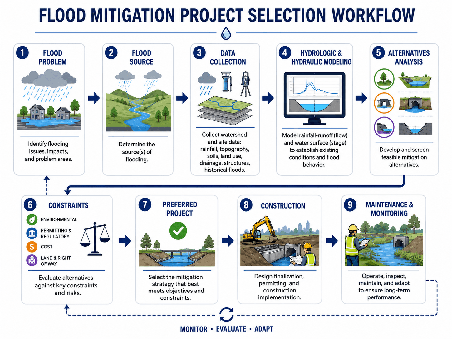
The workflow should be read as a cycle rather than a one-time checklist. A project may return to earlier steps when better survey data, public feedback, environmental constraints, or model results show that the first alternative does not perform as expected.
Start with the flood source
A street drainage problem caused by undersized inlets is not the same as river overbank flooding, coastal surge, shallow sheet flow, dam-related inundation, or a culvert backwater problem. The wrong diagnosis leads to the wrong project.
Use hydrology and hydraulics together
Hydrology estimates how much water arrives and when it arrives. Hydraulic analysis evaluates how that water moves through channels, floodplains, pipes, culverts, bridges, pumps, and structures. Flood mitigation decisions usually need both.
Screen alternatives before committing to design
A strong alternatives analysis compares multiple feasible options against risk reduction, land requirements, permitting, constructability, public impact, maintenance access, downstream effects, and life-cycle performance. The lowest-construction-cost option is not always the best mitigation project.
What Controls the Design of Flood Mitigation Projects?
Flood mitigation design is controlled by both water behavior and project constraints. The same project type can perform very differently depending on rainfall intensity, watershed size, soil infiltration, tailwater, available storage, debris, downstream capacity, and whether the system is maintained after construction.
| Design control | Why it matters | Engineering implication |
|---|---|---|
| Flood source | Urban runoff, river overbank flow, coastal surge, groundwater, and drainage backups behave differently. | The project may need storage, conveyance, protection, elevation, warning, or land-use changes rather than a single standard solution. |
| Design storm or flood frequency | Projects are usually evaluated against selected storm events, recurrence intervals, rainfall depths, or flood elevations. | A project may perform well for frequent events but still be overtopped or bypassed during rarer events. |
| Peak flow and hydrograph timing | Flooding depends on both the maximum flow and when flows from different subareas arrive. | Storage projects must reduce and delay the peak without creating a worse timing problem downstream. |
| Floodplain storage | Floodplains naturally store water and reduce downstream peaks when they are connected to the river. | Filling, encroachment, or walls can remove storage unless compensated by restoration, excavation, or alternative capacity. |
| Tailwater and downstream capacity | A downstream river, lake, tide, culvert, or storm sewer can control how fast water leaves a project area. | Upsizing upstream conveyance may not help if the downstream system is already controlling the water surface. |
| Maintenance access | Sediment, vegetation, trash, and debris can reduce hydraulic capacity over time. | Projects need inspection access, cleanout points, vegetation management, and clear maintenance responsibility. |
A flood mitigation project can be technically correct on paper and still underperform if debris blocks the outlet, vegetation changes roughness, sediment fills storage volume, or downstream tailwater is higher than assumed.
Flood Mitigation Project Selection Table
The best mitigation approach depends on the flood problem, not the project name. Use the table below as a practical screening guide before moving into detailed modeling, permitting, and design.
Identify the flood source, map the affected assets, estimate the water depth and timing, list feasible project types, check downstream effects, then screen each alternative against land, cost, constructability, maintenance, and residual risk.
| Flood problem | Likely mitigation options | What to check before selecting |
|---|---|---|
| Street flooding during intense rainfall | Storm drain upgrades, inlet improvements, detention basin, green streets, bioswales, overflow routing | Rainfall intensity, inlet capture, pipe capacity, low points, downstream tailwater, emergency overflow path, and debris clogging potential. |
| River overbank flooding | Floodplain restoration, levee, floodwall, property elevation, buyout, floodplain preservation | Base flood elevation, floodplain storage, velocity, freeboard, access during floods, environmental impacts, and residual risk if protection is overtopped. |
| Repetitive structure flooding | Elevation, floodproofing, acquisition, relocation, localized drainage improvement | Flood depth, flood duration, building type, foundation condition, access, utility protection, insurance context, and whether site drainage is actually the cause. |
| Undersized culvert or bridge opening | Culvert enlargement, bridge replacement, channel stabilization, debris rack review, upstream storage | Headwater, tailwater, outlet erosion, sediment, debris, roadway overtopping, fish passage, and whether the downstream channel can safely accept more flow. |
| New development increasing runoff | Detention, retention, infiltration, floodplain preservation, low-impact development, runoff volume controls | Pre-development and post-development hydrology, runoff volume, peak timing, water quality treatment, soil infiltration, and long-term maintenance responsibility. |
Urban projects should also connect to broader urban stormwater management, because street flooding often depends on drainage design, inlet spacing, surface routing, impervious cover, and downstream receiving capacity.
Design Tradeoffs in Flood Mitigation Projects
Flood mitigation projects involve tradeoffs between protection, cost, land, environmental impact, maintenance, and public acceptance. A technically strong project should reduce risk without creating an unacceptable new problem somewhere else in the watershed.
- Storage versus conveyance: Storage reduces and delays a peak, while conveyance moves water away faster. Conveyance can help locally but may increase downstream flows if not checked carefully.
- Structural protection versus exposure reduction: A floodwall may protect a dense area, while elevation or buyout may be better for isolated repetitive-loss structures.
- Green infrastructure versus gray infrastructure: Green systems can reduce runoff and improve water quality, but large flood events may still require engineered overflow paths, culverts, channels, or pump capacity.
- Capital cost versus life-cycle reliability: A project with lower construction cost may become expensive if sediment removal, vegetation control, inspections, or pump operations are difficult.
This is why flood mitigation projects often connect to broader water resources management. The project is not just a structure; it is part of a watershed system with upstream inputs, downstream consequences, and long-term community needs.
Senior Engineer Review Checks for Flood Mitigation Projects
A flood mitigation concept should be easy to explain, but it also needs enough documentation to survive design review. A useful mitigation design should identify the design event, overflow path, protected assets, residual-risk scenario, and who will inspect and maintain the system after construction.
| Review item | What it should document | Why it matters |
|---|---|---|
| Flood source and design event | The rainfall event, flood frequency, water surface elevation, or scenario the project is intended to address. | Prevents the project from being judged against an undefined or unrealistic level of protection. |
| Existing and proposed conditions | Water surface elevations, peak flows, inundation limits, velocities, and affected assets before and after the project. | Shows whether the project actually reduces the flood problem it was intended to solve. |
| Emergency overflow route | Where water goes when the system exceeds capacity, blocks, overtops, or loses power. | Reduces the chance that an exceeded system sends water through unsafe or unexpected paths. |
| Maintenance owner and access | Who inspects outlets, pumps, culverts, vegetation, sediment, trash racks, erosion protection, and overflow features. | Protects long-term performance after construction and avoids gradual capacity loss. |
| Residual-risk communication | The remaining flood risk after the project, including larger events, failure modes, and bypass routes. | Prevents false confidence and supports better land-use, emergency planning, and public communication. |
Engineering Judgment and Field Reality
Field performance depends on conditions that simplified diagrams often leave out. A detention basin needs usable storage, a controlled outlet, an emergency spillway, stable slopes, and maintenance access. A culvert upgrade needs enough downstream capacity. A levee needs freeboard, inspection, erosion protection, and a clear understanding of what happens if water overtops or bypasses it.
Floodwater follows the lowest available path. If a project blocks one flow path without providing a safe overflow route, water may find a new path through streets, yards, structures, utility corridors, or adjacent properties.
Experienced engineers also look for practical access. If maintenance crews cannot reach a trash rack, outlet, pump, forebay, or sediment area safely, hydraulic performance can decline long before the end of the project’s design life.
When This Breaks Down
Flood mitigation projects break down when the real flood problem is different from the assumed problem, when the design event is exceeded, or when long-term maintenance is not built into the project. They can also underperform when surrounding land use changes faster than the original hydrologic assumptions.
- Design event exceeded: A system designed for frequent or moderate storms may be overtopped during larger events, especially when emergency overflow routes are not planned.
- Downstream control ignored: Increasing upstream conveyance may not reduce flooding if a downstream culvert, river stage, tide, or backwater condition controls the water surface.
- Storage volume lost: Sedimentation, vegetation growth, trash, or undocumented grading can reduce basin storage and outlet performance.
- Residual risk misunderstood: Communities may assume a levee, wall, or basin eliminates risk, leading to development or emergency planning decisions that do not account for failure or overtopping.
- Maintenance responsibility unclear: Flood mitigation systems often fail gradually when ownership, inspection frequency, and cleanout responsibilities are not assigned.
Common Mistakes and Practical Checks
Many flood mitigation mistakes come from treating flooding as a single-location problem instead of a connected watershed problem. A flooded road, backyard, structure, or channel reach may be the visible symptom of a larger hydrologic or hydraulic constraint.
| Common mistake | Why it causes problems | Practical check |
|---|---|---|
| Upsizing a pipe without checking downstream conditions | More flow may reach a downstream bottleneck faster and increase flooding elsewhere. | Review downstream tailwater, channel capacity, bridge openings, and receiving-system level of service. |
| Assuming a detention basin is only a hole in the ground | Outlet controls, emergency spillways, sediment forebays, side slopes, access, and drawdown time control performance. | Check storage-elevation relationship, outlet rating, overflow route, embankment stability, and maintenance access. |
| Ignoring floodplain storage | Encroachment can remove natural storage and increase flood elevations or velocities. | Compare pre-project and post-project floodplain storage, conveyance, and water surface elevations. |
| Using green infrastructure without overflow planning | Bioswales, rain gardens, and permeable surfaces may be exceeded during intense storms. | Provide safe bypass routes, underdrains where needed, and a receiving system for overflow. |
| Treating maintenance as optional | Clogged outlets, sediment, invasive vegetation, and damaged erosion protection can reduce capacity. | Define inspection frequency, cleanout triggers, access routes, responsible owner, and post-storm review procedures. |
Do not describe a flood mitigation project as “flood-proof” unless the design truly supports that claim. Most projects reduce flood risk for a defined range of conditions and leave residual risk that must be communicated.
Relevant Manuals, Data Sources, and Design References
Flood mitigation projects often involve public funding, floodplain management, hydraulic modeling, stormwater criteria, environmental permitting, and local design standards. FEMA-style mitigation categories help organize funding and eligibility, while engineering design still requires site-specific hydrology, hydraulics, constructability, environmental review, maintenance planning, and residual-risk communication.
- FEMA Hazard Mitigation Assistance project type definitions: FEMA flood risk reduction project type definitions explain how mitigation project categories such as property protection, flood risk reduction, localized flood risk reduction, and related hazard mitigation activities are organized for grant and planning purposes.
- Project-specific criteria: Local drainage manuals, floodplain ordinances, stormwater criteria, owner requirements, environmental permits, and roadway or utility standards may control the final design approach.
- Engineering use: Designers typically combine hydrologic data, hydraulic modeling, field observations, mapping, maintenance needs, and public safety objectives before recommending a preferred flood mitigation alternative.
Frequently Asked Questions
A flood mitigation project is a planned measure that reduces flood risk to people, buildings, roads, utilities, and other infrastructure. It may use structural works such as levees and culverts, nonstructural actions such as elevation or buyouts, or nature-based systems such as wetlands, floodplain restoration, bioswales, and detention basins.
Common examples include detention basins, retention ponds, levees, floodwalls, culvert upgrades, bridge opening improvements, channel stabilization, storm drain upgrades, pump stations, home elevation, floodproofing, property acquisition, wetland restoration, floodplain reconnection, bioswales, rain gardens, and permeable pavement.
Flood control usually refers to physically controlling or redirecting floodwater with structures such as levees, channels, pumps, or floodwalls. Flood mitigation is broader because it also includes reducing exposure, elevating structures, acquiring high-risk properties, restoring floodplains, improving drainage, and planning safer land use.
No. Flood mitigation projects reduce risk, but they do not eliminate it. A project may be designed for a selected storm event, flood elevation, runoff volume, or level of service, and larger events, clogged drainage structures, poor maintenance, downstream tailwater, or changes in land use can still cause flooding.
Engineers start by identifying the flood source, then review rainfall, runoff, topography, soils, drainage networks, floodplain storage, structures, historical flooding, and downstream constraints. The preferred project is usually selected by comparing risk reduction, constructability, land needs, permitting, maintenance, environmental effects, public safety, and cost.
Summary and Next Steps
Flood mitigation projects reduce flood risk by changing how water is stored, conveyed, slowed, redirected, or managed around vulnerable people and infrastructure. The strongest projects are selected from the flood source outward, not by choosing a standard solution before the problem is understood.
Effective mitigation depends on hydrology, hydraulics, floodplain behavior, maintenance access, downstream effects, constructability, public safety, and residual risk. Structural projects, nonstructural measures, and nature-based systems all have a place, but each must be matched to the site and checked against real field conditions.
Where to go next
Continue your learning path with related Turn2Engineering resources.
-
Hydrology
Build the foundation for understanding rainfall, runoff, flood frequency, storage, hydrographs, and watershed response.
-
Water Resources Modeling
Learn how hydrologic and hydraulic assumptions are organized into models used for flood studies and mitigation alternatives.
-
Flood Risk Assessment
Learn how engineers evaluate flood exposure, consequences, likelihood, and residual risk before selecting a mitigation strategy.