Key Takeaways
- Core idea: Flood management reduces flood risk by controlling runoff, preserving storage, improving conveyance, and limiting exposure in flood-prone areas.
- Engineering use: Water resources engineers use flood management to size drainage systems, evaluate floodplains, design detention, protect infrastructure, and plan safer communities.
- What controls it: Rainfall intensity, watershed size, land cover, soil infiltration, channel capacity, floodplain storage, tailwater, maintenance, and development patterns all affect flood behavior.
- Practical check: A good flood plan does not only lower peak flow; it also checks overflow routes, storage volume, downstream impacts, maintenance access, and emergency response.
Table of Contents
Introduction
Flood management is the water resources engineering practice of reducing flood risk by controlling runoff, improving drainage, preserving floodplain storage, protecting critical infrastructure, and helping communities prepare for extreme water levels. It combines hydrology, hydraulics, land planning, infrastructure design, monitoring, maintenance, and emergency response so floodwater has a safer path through the watershed.
Flood Management Diagram
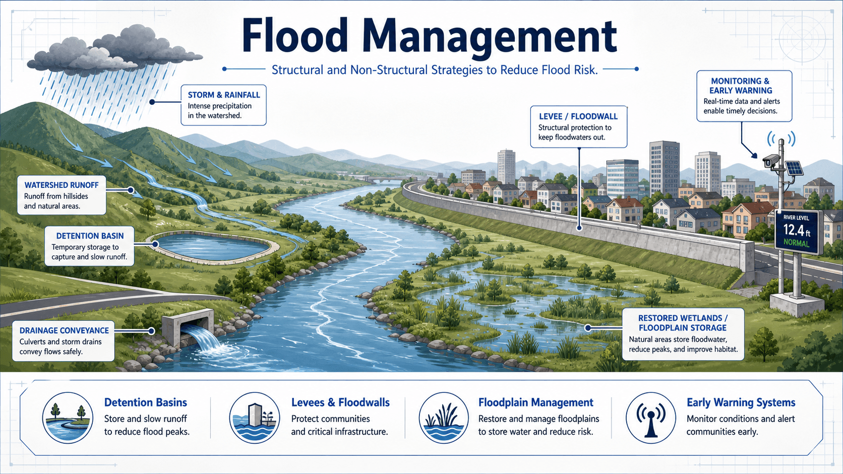
Notice that flood management is not one structure or one calculation. The strongest approach treats the entire watershed as a connected water resources system where rainfall, runoff, channels, floodplains, infrastructure, and people all influence risk.
What is Flood Management?
Flood management is the planning and engineering process used to reduce the probability, severity, and consequences of flooding. It includes physical water resources infrastructure such as detention basins, culverts, storm drains, levees, floodwalls, pump stations, channel improvements, and spillways, but it also includes non-structural measures such as floodplain zoning, emergency planning, floodproofing, public warning, and long-term watershed protection.
In water resources engineering, flood management is different from simply moving water away as fast as possible. A poorly planned drainage improvement can protect one site while increasing peak flow, erosion, or flood depth downstream. A good flood management strategy balances peak discharge, runoff volume, storage, timing, water surface elevation, public safety, environmental impact, constructability, and maintenance.
How Flooding Develops Across a Watershed
Flooding begins when rainfall, snowmelt, storm surge, or upstream releases produce more water than the watershed, channel, drainage network, or floodplain can safely store and convey. The result may be shallow urban ponding, roadway overtopping, riverine flooding, flash flooding, basement flooding, erosion, or damage to buildings and utilities.
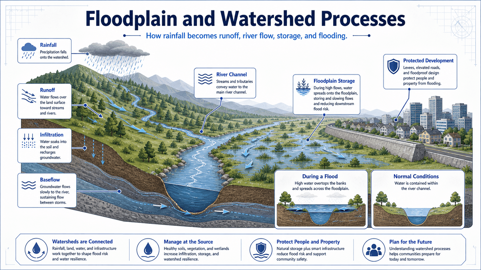
Rainfall does not instantly become flooding
Some rainfall is intercepted by vegetation, some infiltrates into soil, some is stored in depressions, and some becomes surface runoff. Urbanization usually increases runoff because rooftops, pavement, compacted soils, and storm drains reduce infiltration and shorten the travel time to receiving channels.
Floodplains are part of the hydraulic system
A floodplain is not wasted land; it is natural storage and conveyance area that becomes active during high flows. When floodplains are filled, narrowed, or heavily developed, the river loses space to spread out. That can increase water surface elevations, velocity, erosion, and downstream flood risk.
Infrastructure and Planning-Based Flood Management
Flood management is strongest when physical water resources infrastructure and planning-based measures work together. Infrastructure measures change the movement, storage, or containment of water. Planning-based measures reduce exposure, improve preparedness, and help people avoid or respond to flood hazards.
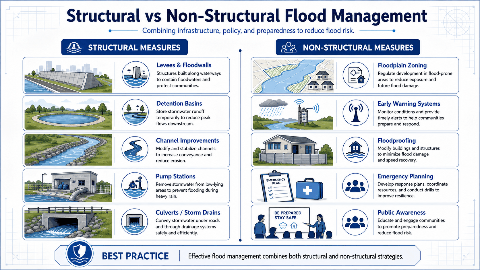
Physical flood infrastructure
Physical flood infrastructure includes levees, floodwalls, detention basins, reservoirs, channels, culverts, storm drains, pump stations, bridge openings, spillways, and outlet controls. These systems can reduce flood depth or frequency, but they require design capacity, maintenance, inspection, and overflow planning.
Planning-based measures
Planning-based flood management includes floodplain zoning, elevation requirements, floodproofing, buyouts, public warning systems, emergency planning, land conservation, insurance mapping, and public education. These measures often reduce long-term risk more effectively than adding larger pipes everywhere.
How Water Resources Engineers Use Flood Management
Water resources engineers use flood management when evaluating existing flood risk, designing new development, improving drainage infrastructure, protecting critical facilities, restoring floodplains, or reviewing whether a project creates adverse downstream impacts.
- Drainage design: sizing storm drains, culverts, inlets, channels, detention basins, outfalls, and overflow routes.
- Floodplain analysis: estimating water surface elevations, flood extents, storage impacts, bridge backwater, and overbank flow patterns.
- Watershed planning: reducing runoff at the source through land cover planning, green infrastructure, infiltration, wetlands, and distributed storage.
- Infrastructure protection: checking whether roads, substations, pump stations, wastewater assets, buildings, and access routes remain functional during design storms.
- Emergency readiness: connecting gage data, forecast thresholds, warning systems, closure plans, and response routes.
Always ask where the water goes when the design capacity is exceeded. A drainage system that works for the selected design storm can still fail dangerously if overflow routes direct water toward buildings, electrical equipment, roadway low points, or trapped depressions.
Key Factors That Control Flood Risk
Flood risk is controlled by both hydrologic inputs and hydraulic response. Rainfall creates the water load, the watershed transforms that water into runoff, and the drainage or river system determines how high and fast that water moves through the landscape.
| Factor | Why it matters | Engineering implication |
|---|---|---|
| Rainfall intensity and duration | Short intense storms can cause flash flooding, while long storms can fill storage and raise river levels. | Design must check both peak flow and total runoff volume, not just one storm duration. |
| Watershed land cover | Pavement, roofs, compacted soil, and storm drains increase runoff and shorten travel time. | Urban areas often need detention, green infrastructure, and safe overflow paths. |
| Soil infiltration and antecedent moisture | Wet soils produce more runoff because storage and infiltration capacity are already reduced. | Flood modeling should consider realistic soil moisture and seasonal conditions. |
| Channel and culvert capacity | Undersized or obstructed conveyance can back water up and flood roads or properties. | Hydraulic checks must include tailwater, debris, sediment, inlet control, outlet control, and maintenance access. |
| Floodplain storage | Overbank areas store water and reduce downstream peaks when they remain connected to the river. | Filling floodplains or disconnecting wetlands can increase water levels and transfer risk downstream. |
| Maintenance condition | Clogged inlets, blocked culverts, sedimented basins, and failed flap gates reduce actual capacity. | Flood management must include inspection and maintenance, not just design drawings. |
Flood Hydrographs and Peak Flow Reduction
A flood hydrograph shows how discharge changes over time during and after a storm. Flood management often tries to reduce the peak discharge, delay the time to peak, or spread runoff over a longer period so downstream channels and infrastructure are less likely to overtop.
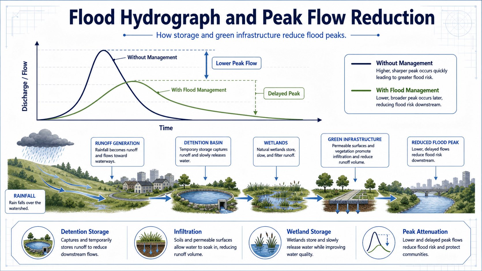
A simplified way to understand peak reduction is that storage temporarily holds part of the runoff volume and releases it later. This does not make the water disappear. It changes the timing and rate of discharge.
In practice, engineers check inflow hydrographs, outlet capacity, storage-elevation curves, tailwater, emergency overflow, drawdown time, downstream channel capacity, and maintenance conditions. A basin that lowers the peak but stays full too long may perform poorly during back-to-back storms.
- Q Discharge or flow rate, commonly expressed in cubic feet per second (cfs) or cubic meters per second (m³/s).
- Peak flow The maximum discharge during a storm event; often a controlling value for culverts, channels, bridges, and floodplain analysis.
- Storage Temporary water volume stored in basins, wetlands, reservoirs, channels, or floodplains to reduce or delay discharge.
Flood Management Design Review Checklist
A flood management plan should be reviewed as a connected water resources system, not as a collection of isolated structures. The checklist below helps identify whether the plan addresses the source of runoff, the flow path, storage, conveyance, overflow, exposure, and long-term performance.
Start with the watershed and rainfall data, estimate runoff and flood timing, check existing conveyance and floodplain storage, select a combination of physical infrastructure and planning-based measures, test downstream impacts, define overflow routes, then confirm maintenance and emergency response assumptions.
| Check or decision | What to look for | Why it matters |
|---|---|---|
| Define the flood problem | River flooding, urban ponding, culvert backup, road overtopping, erosion, coastal surge, or combined causes. | The solution depends on the mechanism; a larger pipe may not fix a floodplain storage or tailwater problem. |
| Check both peak and volume | Peak discharge, hydrograph shape, runoff volume, storm duration, and back-to-back storm behavior. | Peak-only design can miss storage depletion, long-duration flooding, and delayed downstream impacts. |
| Protect safe overflow routes | Where water flows when inlets clog, culverts surcharge, basins overtop, or rainfall exceeds the design storm. | Extreme events will exceed design capacity; damage is reduced when overflow paths are intentional. |
| Evaluate downstream effects | Changes in timing, peak flow, erosion potential, flood elevation, channel stability, and receiving system capacity. | A project should not simply transfer flood risk to downstream properties or infrastructure. |
| Confirm maintainability | Access for sediment removal, vegetation control, outlet inspection, debris removal, gate operation, and sensor upkeep. | Flood systems lose capacity over time when maintenance is not realistic or funded. |
Example: Choosing the Right Flood Management Strategy
Consider a small urban watershed where new development increases pavement and sends runoff quickly toward an undersized culvert. Downstream residents already experience yard flooding during larger storms, and the receiving channel shows bank erosion.
Weak solution: only enlarge the culvert
Enlarging the culvert may reduce local roadway flooding, but it can also send a sharper, faster peak downstream. If the downstream channel is already unstable, the project may solve one visible problem while worsening erosion and flood depth elsewhere.
Stronger solution: combine storage, conveyance, and exposure reduction
A better strategy may include upstream detention, green infrastructure to reduce runoff volume, a culvert upgrade sized with tailwater and debris considered, channel stabilization where needed, preserved floodplain storage, and an emergency overflow path that keeps water away from homes and critical utilities.
Engineering meaning
The best flood management strategy is rarely the biggest structure. It is the combination of measures that lowers risk across the whole watershed while accounting for hydraulic capacity, storage, downstream impacts, operations, and real maintenance conditions.
Engineering Judgment and Field Reality
Flood management depends heavily on assumptions that can fail in the field. Rainfall may exceed the design storm, culverts may clog with debris, detention basins may lose volume to sediment, floodwalls may create a false sense of security, and land development may change runoff faster than design records are updated.
The modeled flood line is not a wall. Actual flood limits can shift because of debris, blocked inlets, local grading, fence lines, sediment, vegetation, tailwater, bridge constrictions, and storm patterns that differ from the design event.
Experienced water resources engineers look for secondary flow paths, low points, trapped drainage areas, erosion scars, high-water marks, undersized driveway culverts, poor outlet protection, inaccessible maintenance areas, and locations where people may drive into flooded roads before warnings are issued.
When This Breaks Down
Flood management breaks down when the real watershed behaves differently from the assumptions used in planning, modeling, design, or maintenance. This is especially common when a project focuses on a single structure instead of the complete flood pathway.
- Storage is undersized or unavailable: detention and floodplain storage do not reduce risk if they are already full, filled in, sedimented, or disconnected from flow.
- Conveyance is blocked: culverts, inlets, bridges, channels, and outlet structures can lose capacity from debris, sediment, vegetation, ice, or poor maintenance.
- Downstream impacts are ignored: faster conveyance can increase downstream peaks, velocities, erosion, and flood stages.
- Development changes the watershed: new pavement, grading, compacted soils, and drainage connections can increase runoff after the original design.
- Risk communication fails: people may assume a levee, map boundary, or design storm means no flooding can occur.
Common Mistakes and Practical Checks
Flood management mistakes often come from treating water as a local nuisance instead of a watershed-scale system. The most common errors are not always calculation errors; many are judgment, maintenance, or boundary-condition problems.
- Designing only for the selected storm: a system also needs a safe failure mode for larger events.
- Ignoring tailwater: a culvert or outfall may not drain as expected when the downstream channel is already high.
- Forgetting debris and sediment: the clean design capacity may not match the capacity during an actual storm.
- Focusing only on peak discharge: volume, duration, drawdown time, and timing between subwatersheds can be just as important.
- Assuming green infrastructure is maintenance-free: permeable surfaces, bioswales, and infiltration areas can clog or fail when soils, pretreatment, and maintenance are neglected.
Do not assume that moving water away faster is automatically safer. Faster conveyance can reduce flooding at one location while increasing downstream flood peaks, erosion, and infrastructure stress.
Relevant Manuals, Data Sources, and Design References
Flood management uses project-specific criteria, local requirements, hydrologic data, hydraulic modeling, and floodplain guidance. The references below are useful starting points for understanding rainfall, streamflow, floodplains, hydraulic modeling, and regulatory flood hazard analysis.
- Local stormwater design manuals: define design storms, allowable discharge, detention requirements, water quality requirements, freeboard, overflow routing, and drainage criteria for a specific jurisdiction.
- NOAA precipitation frequency data: provides rainfall depth and intensity information commonly used for hydrologic and stormwater design in the United States.
- USGS streamgages and water data: support flood frequency review, watershed studies, streamflow analysis, and calibration of hydrologic assumptions.
- FEMA flood maps and floodplain guidance: provide flood hazard mapping, base flood elevation context, and regulated floodplain information used in planning and design review.
- FEMA hydraulic numerical models: a useful reference for flood hazard analysis because it identifies hydraulic models that meet National Flood Insurance Program requirements for flood hazard mapping and related floodplain studies.
- USACE HEC-RAS documentation: a key reference for hydraulic modeling because it explains HEC-RAS theory, data requirements, hydraulic assumptions, model parameters, and modeling approaches used in river and floodplain analysis.
Frequently Asked Questions
Flood management is the planning, analysis, design, and operation of systems that reduce flood risk. It includes watershed runoff control, river and floodplain analysis, stormwater storage, levees, floodwalls, drainage conveyance, early warning systems, land-use planning, and emergency preparedness.
Flood control usually refers to physical measures that try to contain or redirect water, such as levees, channels, culverts, detention basins, and pump stations. Flood management is broader because it also includes zoning, warning systems, floodproofing, preparedness, maintenance, risk communication, and long-term watershed planning.
Common flood management methods include detention and retention basins, levees, floodwalls, channel improvements, culverts, storm drains, pump stations, restored wetlands, floodplain preservation, green infrastructure, floodplain zoning, floodproofing, real-time monitoring, and emergency response planning.
Detention basins and wetlands reduce flood peaks by temporarily storing runoff and releasing it more slowly. This spreads flow over a longer period, lowers the peak discharge, delays the time to peak, and can reduce downstream erosion, overtopping, and drainage system overload when the storage is properly designed and maintained.
Summary and Next Steps
Flood management is the practical water resources engineering process of reducing flood risk across watersheds, rivers, floodplains, drainage systems, and developed communities. It works best when hydrologic analysis, hydraulic capacity, storage, conveyance, land-use planning, monitoring, and maintenance are treated as one connected system.
The most important checks are peak flow, runoff volume, storage, overflow routing, downstream impacts, floodplain function, maintenance condition, and emergency response. A reliable flood strategy does not rely on one pipe, basin, levee, or map line; it uses layers of protection and realistic field judgment.
Where to go next
Continue your learning path with related Turn2Engineering resources.
-
Hydrology
Learn how rainfall, runoff, infiltration, storage, and streamflow are estimated before flood management measures are designed.
-
Stormwater Management
Review runoff control, detention, retention, drainage planning, and green infrastructure for developed areas.
-
Water Resources Modeling
Explore how hydrologic and hydraulic models help engineers evaluate flood scenarios, infrastructure changes, and watershed response.