Key Takeaways
- Definition: A geotechnical investigation is the field and laboratory program used to define subsurface conditions and reduce uncertainty before design and construction.
- Use case: It supports foundations, retaining systems, slopes, embankments, pavements, excavations, and groundwater-sensitive work.
- Main decision: The key choice is not just how many borings to drill, but whether the investigation answers the project’s actual failure and performance questions.
- Outcome: After reading, you should understand how engineers scope, execute, interpret, and quality-check a geotechnical investigation in practice.
Table of Contents
Introduction
In brief: Geotechnical investigation is the process of exploring the ground, testing materials, and interpreting subsurface conditions so engineers can design with less uncertainty and lower risk.
Who it’s for: Students, FE/PE prep, and practicing geotechnical designers.
A strong investigation is not just about collecting soil samples. It is about asking the right subsurface questions early enough to influence foundation type, settlement expectations, groundwater strategy, and construction planning.
Geotechnical Investigation infographic
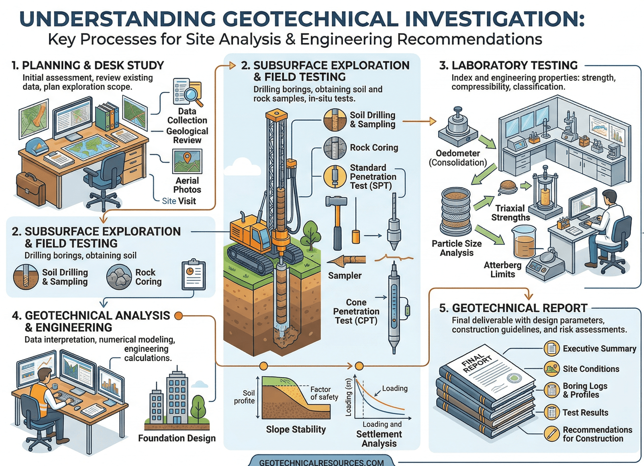
Notice that the value is not in any one boring or lab test by itself. The useful output is the interpreted ground model: what layers are present, where the weak zones are, how groundwater behaves, and which uncertainties still matter to design.
What is geotechnical investigation?
Geotechnical investigation is the organized process of finding out what lies below the ground surface and whether those subsurface conditions can safely support the project being planned. In practical engineering terms, it combines desk study, site reconnaissance, borings or test pits, in-situ testing, sampling, groundwater observations, laboratory testing, and interpretation into a usable foundation for design.
The reason this matters is simple: the structure you can see is only half the problem. The ground controls bearing capacity, settlement, lateral resistance, seepage, slope behavior, excavation stability, and long-term movement. If the subsurface model is weak, the design can look polished on paper and still perform poorly in the field.
A geotechnical investigation also sits at the center of several downstream decisions. It influences whether shallow foundations are feasible, whether deep foundations are needed, whether retaining systems require drainage or movement controls, whether problematic fill or soft layers must be treated, and whether the construction sequence itself introduces risk.
That is why experienced engineers do not ask only, “How many borings do we need?” They ask, “What failure modes or serviceability concerns must this investigation rule in or rule out?”
Core principles, variables, and units
A good investigation is driven by the project’s controlling mechanisms. For one site, the key issue may be undrained shear strength in soft clay. For another, it may be liquefaction susceptibility, expansive clay activity, variable fill thickness, rock rippability, or perched groundwater. The investigation is only “good” if it captures the variables that actually control performance.
Key variables and typical ranges
Geotechnical investigations often combine descriptive observations with measured values. Some of the most important numbers are not universal design values by themselves, but indicators that guide what further testing, interpretation, or risk checks are needed.
- \(z\) Depth below grade, typically in ft or m; used to map layer changes, groundwater, and the influence zone below foundations or earthworks.
- N SPT blow count; a field indicator of relative density or consistency, commonly corrected before interpretation and never used blindly without context.
- \(w\) Moisture content, usually as a percent; helps interpret compaction, compressibility, consistency, and whether samples are representative.
- \(\gamma\) Unit weight in pcf, kN/m³, or kips/ft³; important for overburden stress, earth pressures, and embankment loading.
- \(c_u\), \(c’\), \(\phi’\) Strength parameters from field and lab interpretation; central to bearing, slope, retaining, and excavation design.
- \(k\) Hydraulic conductivity, usually ft/s or m/s; controls seepage behavior, dewatering demands, and drainage performance.
- \(C_c\), \(m_v\), OCR Compressibility and stress-history indicators used to estimate settlement and time-dependent movement in fine-grained soils.
The best sanity check is to compare every interpreted parameter against how the material actually looked, felt, and behaved in the field. Numbers without geologic context are where many bad recommendations begin.
Units matter more than many beginners expect. Subsurface data often mixes US customary and SI reporting, field measurements, and older lab references. A clean investigation log and report must make it obvious which system is being used and whether the values shown are measured, corrected, or interpreted.
Investigation workflow and decision logic
A geotechnical investigation should follow a sequence that starts with project questions rather than with drill rig logistics. The field plan comes after the risk framing, not before it.
1) Define the project and likely failure modes. 2) Review geology, topo, existing reports, utilities, and groundwater context. 3) Choose exploration methods and spacing to target uncertainty. 4) Sample and test the right materials. 5) Build the subsurface model. 6) Translate that model into design and construction recommendations. 7) State what remains uncertain.
For shallow foundations, the workflow often centers on bearing, settlement, variability, and groundwater. For retaining walls and deep excavations, lateral earth pressures, seepage, temporary conditions, and adjacent asset sensitivity become more important. For embankments or slabs, compressibility, fill quality, and moisture-density control may dominate.
This is why the same boring spacing is not appropriate for every project. A warehouse slab over broadly uniform dense sand may justify a different exploration density than a hillside site with colluvium over weathered rock, or a downtown excavation next to old utilities and nearby structures.
Early-stage investigations are often phased. A first phase establishes the broad subsurface model. A later phase tightens the design around the parts that matter most, such as a suspected soft zone, a wall alignment, a deep footing area, or a groundwater-sensitive excavation.
Equations and calculations
Geotechnical investigation is not governed by one master equation, but there are a few simple relationships that help engineers decide whether the exploration program is deep enough to matter.
In plain language, the exploration depth should extend far enough below the foundation or loaded area to capture the zone where the added vertical stress from the project is still significant. The exact cutoff depends on the project, but the principle is the same: stop drilling too early, and deeper weak or compressible layers can still control settlement.
Effective vertical stress, total vertical stress, and pore-water pressure are central to interpreting the investigation. Many field and lab observations only make sense when groundwater conditions are understood correctly. A material that seems firm during a dry visit may behave very differently when pore pressures rise.
These equations are not the final design. They are reminders that the investigation must capture the stress and groundwater conditions that will actually drive behavior. That means the boring depth, sampling quality, and groundwater monitoring strategy should all reflect the load path and construction sequence.
Worked example: planning an investigation for a shallow foundation site
Example
Imagine a two-story building on a suburban site with mixed fill over natural clay and sand. The owner wants shallow foundations if possible, but there are also concerns about floor slab movement and wet-season excavation. A weak investigation would drill only a few borings to a shallow depth and report generic allowable bearing values. A useful investigation starts by identifying the real questions: How thick is the fill? Is it engineered? Are the clays compressible or expansive? Is groundwater seasonal? Does a deeper soft layer influence settlement?
The engineer reviews geologic mapping, grading history, and nearby reports, then lays out borings at the building corners and central load areas, with deeper exploration where heavier column loads are expected. Split-spoon sampling and basic index testing are used in the upper profile, while selected undisturbed samples target fine-grained layers that may control settlement. Groundwater observations are logged during drilling and, if the site is sensitive, confirmed later after stabilization.
The result is not just a stack of logs. It is a design-ready interpretation: undocumented fill is limited to the upper few feet in some areas, natural clays are moderately plastic, shallow sands can support spread footings where the fill is removed or improved, and slab-on-grade areas need moisture and subgrade control to reduce differential movement. That is a successful investigation because it changed the recommendations in a way that reduced uncertainty and improved constructability.
Engineering judgment and field reality
In the field, geotechnical investigations rarely happen under perfect conditions. Access can be limited, drilling fluids can disturb soft materials, groundwater can fluctuate, utilities can block ideal locations, and a small number of borings may need to represent a very large area. That is why engineering judgment matters as much as drilling footage.
One of the biggest field realities is variability. Soil does not care that a boring was taken ten feet away. Two locations that look similar on a plan may behave very differently if one intersects buried fill, an old trench line, a soft pocket, or a perched water zone. The investigation program has to be honest about that uncertainty instead of smoothing it away.
Another field reality is sample quality. Disturbed samples can still be useful for classification, but they are not interchangeable with undisturbed samples for settlement or strength interpretation in fine-grained soils. Likewise, a groundwater elevation noted during drilling is not always the long-term groundwater table. Drilling activity itself can temporarily alter what you observe.
The most useful geotechnical recommendation often comes from connecting imperfect field observations to the consequence of being wrong. If a missed weak layer could trigger differential settlement or wall movement, the investigation needs to be tightened there, not just averaged out in the report.
Good field judgment also means matching effort to consequence. A light, low-risk project may justify a more limited program. A critical wall, deep excavation, bridge foundation, or soft-ground embankment may justify staged investigation, instrumentation, or targeted follow-up exploration after the first data set is reviewed.
When this breaks down
A geotechnical investigation breaks down when it gathers information without resolving the project’s meaningful uncertainty. That can happen even when the report is long and the logs look professional.
One common failure point is using spacing or depth rules mechanically, without asking whether the site is actually uniform. Another is overreliance on one data type. SPT values alone, for example, do not fully describe compressibility, expansive behavior, or groundwater risk. The same is true when a few lab tests are treated as more representative than they really are.
Investigations also break down when temporary conditions are mistaken for long-term conditions. A dry-season exploration may miss wet-season seepage or softening. A quick drilling note may not be enough to characterize a perched water table, artesian response, or delayed groundwater stabilization.
On more complex projects, the method breaks down when interpretation is not tied to the actual design load path or construction sequence. For example, a retaining wall investigation that does not adequately characterize backfill, foundation soils, or drainage behavior can leave the critical design questions unanswered even if the report contains many pages of data.
Common pitfalls and engineering checks
- Assuming the investigation is complete just because the minimum planned borings were drilled.
- Collecting samples and tests that do not match the design questions.
- Treating groundwater noted during drilling as the final groundwater condition.
- Using interpreted parameters without checking sample quality and geologic consistency.
- Reporting generic recommendations without clearly stating what uncertainty remains.
A costly mistake is giving a single neat allowable bearing value while hiding that the site contains variable fill or a deeper compressible layer. Clean numbers do not reduce risk if the subsurface model underneath them is wrong.
| Investigation check | Why it matters | Typical units or format | Engineering note |
|---|---|---|---|
| Boring/CPT depth | Controls whether deeper influence layers are captured | ft or m | Depth should reflect loading and consequences, not just a default target. |
| Groundwater observations | Controls effective stress, seepage, and excavation planning | Elevation, depth, time | One observation during drilling is often not enough for sensitive work. |
| Sample quality | Affects credibility of lab strength and settlement data | Visual/logging notes | Undisturbed sampling should be targeted where fine-grained behavior controls design. |
| Layer continuity | Drives variability and differential performance risk | Profile interpretation | Do not assume continuity between wide-spaced borings without geologic support. |
| Report transparency | Defines how well downstream teams understand limitations | Narrative + logs + recommendations | State assumptions, excluded areas, and follow-up needs explicitly. |
A senior-level review usually asks a simple set of questions: Did the exploration reach the controlling layers? Did the testing program match the design risks? Are groundwater conditions defensibly characterized? Is the interpretation honest about variability? And do the recommendations change meaningfully if the uncertain zones are worse than expected?
Visualizing geotechnical investigation in practice
A helpful mental model is to picture the investigation as a narrowing funnel. At the top is broad uncertainty: regional geology, old fill, groundwater, and unknown construction history. As borings, test pits, CPTs, and lab tests are added, that uncertainty narrows into a ground model that is specific enough to support design.
The goal is not to “know everything underground.” That is impossible. The goal is to reduce uncertainty enough that foundation selection, settlement expectations, retaining design, and construction planning become defensible decisions rather than guesses.
Keep asking one question as you read logs and test data: what project decision does this information improve?
Relevant standards and design references
Geotechnical investigation draws from multiple field and laboratory standards rather than from one single code section. The most useful references are the ones that make the subsurface data defensible, repeatable, and suitable for the decisions being made.
- ASTM D1586: Standard Penetration Test procedures and sampling in soils; widely used for subsurface exploration and field consistency or density indicators.
- ASTM D2487 and ASTM D2488: Soil classification by USCS and visual-manual procedures; critical for turning field and lab observations into a common language.
- ASTM D420: Guide to site characterization for engineering design and construction purposes; useful for framing exploration scope and investigation intent.
- ASTM D1587: Thin-walled tube sampling of fine-grained soils; important where sample quality affects strength and compressibility interpretation.
- AASHTO, FHWA, USACE, and project-specific manuals: Frequently used to align investigation scope with transportation, embankment, excavation, and infrastructure project demands.
In practice, these references matter because the credibility of the design recommendation depends on the credibility of the data behind it. A sophisticated analysis cannot rescue weak field procedures or poorly matched testing.
Frequently asked questions
A geotechnical investigation is the field and laboratory program used to gather subsurface information for a project. Site characterization is the broader interpretation step that turns those observations into a ground model, design parameters, and a clearer understanding of risk.
It should go deep enough to capture the stress influence zone, weak layers, groundwater conditions, and any deeper material that could control settlement, bearing, lateral movement, or excavation behavior for the actual project.
The most common causes are poor exploration spacing, inadequate groundwater characterization, testing that does not match the design questions, and weak integration between logs, lab data, and the real structural or construction decisions.
It matters anywhere the ground controls performance, especially under foundations, retaining walls, slopes, pavements, embankments, excavations, and sites affected by fill, soft soils, settlement risk, or groundwater.
Summary and next steps
Geotechnical investigation is the disciplined process of reducing subsurface uncertainty before the project pays for that uncertainty in design changes, construction delays, or performance problems. The best investigations are not judged by how many pages the report has, but by whether the exploration, testing, and interpretation answer the decisions that actually matter.
In practice, the investigation should connect geology, field methods, groundwater behavior, laboratory testing, and engineering judgment into one coherent ground model. That ground model then supports foundation recommendations, settlement assessments, excavation planning, retaining design, and risk communication.
If there is one practical lesson to remember, it is this: a geotechnical investigation succeeds when it reduces the consequence of being wrong about the ground. Everything else, including boring counts and test lists, should support that outcome.
Where to go next
Continue your learning path with these curated next steps.
-
Read a deeper dive on what geotechnical engineering covers
Useful if you want to place investigation work inside the broader workflow of foundations, slopes, retaining systems, and ground behavior.
-
Study geotechnical risk assessment
A strong next step when you want to connect subsurface uncertainty to consequence, contingency planning, and project-level decision-making.
-
Explore geotechnical data analysis
Helpful for turning field logs, lab results, and spatial variability into clearer parameters and cleaner design inputs.