Key Takeaways
- Core idea: The hydrologic cycle is the continuous movement of water between the atmosphere, land, oceans, rivers, soil, and groundwater.
- Engineering use: Water resources engineers use it to understand runoff, flooding, infiltration, groundwater recharge, drought, water supply, and water quality.
- What controls it: Rainfall intensity, soil condition, slope, vegetation, storage, land use, groundwater conditions, and impervious cover all change how water moves.
- Practical check: Not all rainfall becomes runoff; some water evaporates, infiltrates, recharges groundwater, fills storage, or is delayed before reaching a stream.
Table of Contents
Introduction
The hydrologic cycle, also called the water cycle, is the continuous movement of water through the atmosphere, land surface, oceans, rivers, soil, and groundwater. In water resources engineering, it explains how precipitation becomes runoff, infiltration, groundwater recharge, baseflow, storage, evaporation, and streamflow that must be understood for flood control, stormwater design, water supply, and watershed planning.
Hydrologic Cycle Process Diagram
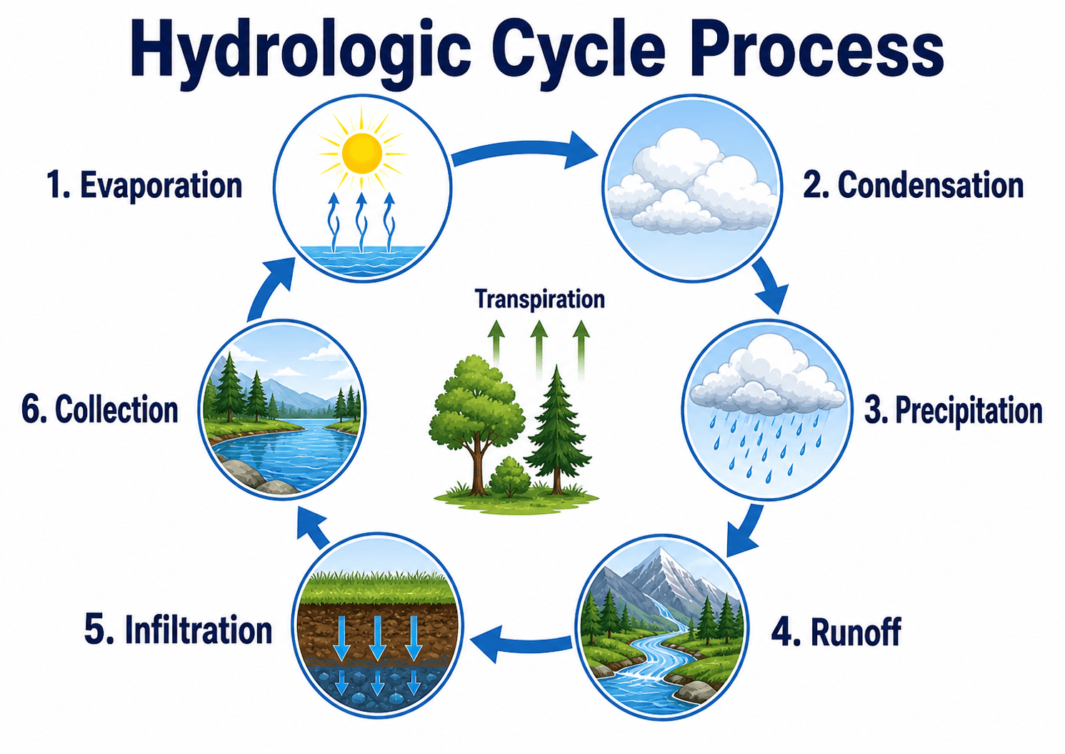
Start with the large arrows. They show that water does not move through one single path; it can return to the atmosphere, move across the land surface, enter the soil, recharge groundwater, or collect in rivers, lakes, and oceans.
What Is the Hydrologic Cycle?
The hydrologic cycle is the natural system that stores and moves water in different forms: liquid water, water vapor, snow, ice, soil moisture, surface water, and groundwater. It is often shown as a circular diagram, but in real watersheds it behaves more like a network of pathways, delays, storage zones, and feedback loops.
For water resources engineering, the important question is not only “Where does water go?” It is also “How fast does it move, how much is stored, how much becomes runoff, how much reaches groundwater, and how does the watershed respond during dry periods and storms?” Those questions connect the hydrologic cycle directly to drainage design, flood studies, reservoir planning, groundwater management, and water quality protection.
A basic water cycle diagram is useful for learning the concept, but engineering work requires estimating timing, volume, storage, infiltration, runoff response, and uncertainty.
How the Hydrologic Cycle Works
The hydrologic cycle is driven mainly by solar energy, gravity, atmospheric circulation, land cover, and subsurface storage. Solar energy causes evaporation and transpiration. Cooling air causes condensation and cloud formation. Gravity moves precipitation downhill as runoff, pulls water through soil and rock, and drives streamflow and groundwater movement.
Evaporation, Transpiration, and Evapotranspiration
Evaporation occurs when water changes from liquid to vapor at oceans, lakes, rivers, wet soils, and other exposed surfaces. Transpiration occurs when plants release water vapor through their leaves. Together, evaporation and transpiration are often grouped as evapotranspiration, which can be a major loss term in water budgets, especially in warm climates, irrigated areas, wetlands, and vegetated watersheds.
Condensation and Precipitation
Condensation occurs when water vapor cools and forms cloud droplets or ice crystals. Precipitation occurs when water returns to the land or ocean as rain, snow, sleet, or hail. In engineering studies, precipitation is usually treated as the main input to a watershed, but the timing, duration, intensity, and spatial distribution of that precipitation strongly affect the response.
Runoff, Infiltration, and Collection
After precipitation reaches the ground, some water may run across the surface, some may infiltrate into the soil, some may be intercepted by vegetation, and some may be stored temporarily in depressions, wetlands, snowpack, reservoirs, or soil pores. Surface runoff eventually collects in swales, storm drains, streams, rivers, lakes, reservoirs, wetlands, or oceans.
Groundwater in the Hydrologic Cycle
Groundwater is the part of the hydrologic cycle that moves below the land surface. When precipitation infiltrates into the soil and continues downward through pore spaces, fractures, and permeable layers, it may recharge an aquifer. From there, groundwater can move slowly toward wells, springs, wetlands, streams, lakes, or the ocean.
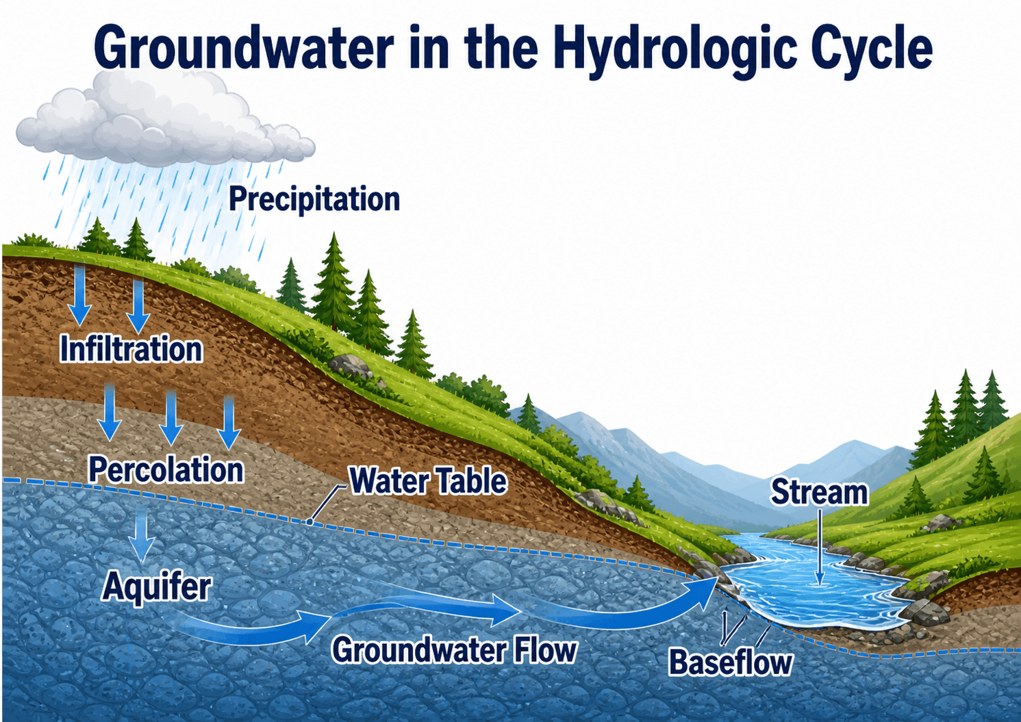
Why Groundwater Creates a Delay
Surface runoff can reach a stream quickly, but groundwater usually moves much more slowly. This delay is important because a watershed may keep releasing water to streams long after rainfall has ended. That delayed contribution is called baseflow, and it helps explain why some streams continue flowing during dry weather.
Why Recharge Is Not Automatic
Infiltration does not always become groundwater recharge. Water may be held as soil moisture, removed by plant roots, evaporated, blocked by low-permeability layers, or routed laterally as shallow subsurface flow. Engineers must be careful not to assume that every inch of infiltrated water reaches an aquifer.
Why the Hydrologic Cycle Matters in Water Resources Engineering
The hydrologic cycle is the starting point for many water resources decisions because it links rainfall, runoff, storage, infiltration, groundwater, and streamflow. Engineers use that understanding to estimate how a watershed behaves under ordinary weather, drought, and extreme storm conditions.
- Stormwater management: Estimating how much rainfall becomes runoff, how fast it reaches drainage systems, and how detention, retention, or green infrastructure can reduce peak flow.
- Flood management: Understanding how precipitation, antecedent moisture, snowmelt, river conveyance, floodplain storage, and downstream timing influence flood risk.
- Groundwater planning: Evaluating recharge, pumping impacts, aquifer storage, groundwater-surface water interaction, and long-term water supply reliability.
- Water quality protection: Recognizing how runoff can carry sediment, nutrients, oils, metals, bacteria, and other pollutants into receiving waters.
- Watershed planning: Comparing how forests, agricultural land, wetlands, urban areas, and impervious surfaces change infiltration, evapotranspiration, runoff, and storage.
Before sizing a drainage feature or interpreting a watershed model, ask whether the site is controlled more by fast surface runoff, shallow soil storage, groundwater response, or a combination of all three.
Key Factors That Control the Hydrologic Cycle
The same rainfall event can produce very different outcomes depending on watershed conditions. A forested basin with deep soils may absorb and delay much of the water, while a paved urban catchment may generate rapid runoff and higher peak flow.
| Factor | Why it matters | Engineering implication |
|---|---|---|
| Rainfall intensity and duration | High-intensity storms can exceed infiltration capacity and produce rapid runoff. | Affects peak flow, inlet capacity, detention sizing, flood routing, and erosion risk. |
| Antecedent soil moisture | Wet soils have less available storage than dry soils. | The same storm can produce much more runoff after previous rainfall. |
| Soil type and compaction | Sandy soils usually infiltrate faster than clayey or compacted soils. | Controls infiltration practices, recharge assumptions, and runoff coefficients. |
| Vegetation and land cover | Plants intercept rainfall, promote infiltration, and return water to the atmosphere through transpiration. | Land clearing can increase runoff volume, erosion, and stream flashiness. |
| Impervious surface | Roofs, roads, sidewalks, and parking lots prevent rainfall from soaking into the ground. | Increases runoff volume and peak flow while reducing natural recharge. |
| Topography | Steeper slopes move water faster and reduce contact time for infiltration. | Influences flow path length, time of concentration, erosion, and channel response. |
| Groundwater level | A shallow water table reduces unsaturated storage and can increase saturation near streams or low areas. | Important for infiltration basins, basements, wetlands, baseflow, and seasonal high-water conditions. |
Basic Hydrologic Water Balance
A simple water balance helps connect the hydrologic cycle diagram to engineering analysis. For a watershed or site, incoming precipitation is divided among runoff, evapotranspiration, infiltration or recharge, and changes in storage.
This equation is a simplified way to organize the system. It does not replace detailed hydrologic modeling, but it helps engineers check whether assumptions make physical sense. If runoff, evapotranspiration, infiltration, and storage changes add up to more water than the precipitation input, something in the estimate is inconsistent.
- P Precipitation input, commonly measured as rainfall or snowmelt depth over a watershed.
- R Runoff leaving the area as overland flow, channel flow, storm drain flow, or other surface discharge.
- ET Evapotranspiration, or water returned to the atmosphere through evaporation and plant transpiration.
- I Infiltration or recharge component, depending on the scale and purpose of the water balance.
- ΔS Change in storage, including soil moisture, depression storage, reservoirs, wetlands, snowpack, or aquifer storage.
Hydrologic Cycle Review Checklist for a Watershed
Use this checklist when reviewing a watershed, drainage study, stormwater concept, or basic hydrologic model. The goal is to confirm that the water pathways shown in a simple diagram are represented realistically in the engineering assumptions.
Start with the precipitation input, then trace where water can go: immediate runoff, interception, surface storage, infiltration, evapotranspiration, groundwater recharge, channel flow, and delayed baseflow. If one pathway is ignored, confirm that it is truly negligible for the site scale and design purpose.
| Check or decision | What to look for | Why it matters |
|---|---|---|
| Define the watershed outlet | Identify where runoff, streamflow, or drainage leaves the study area. | The hydrologic cycle must be applied to a defined area, or the water balance becomes unclear. |
| Check storm conditions | Review rainfall depth, intensity, duration, distribution, and whether snowmelt is relevant. | Storm timing controls peak flow, runoff volume, and drainage system response. |
| Review soil and infiltration assumptions | Look for soil group, compaction, infiltration rate, depth to restrictive layer, and seasonal high water table. | Overestimating infiltration can undersize runoff controls or overstate groundwater recharge. |
| Compare existing and proposed land cover | Check changes in impervious area, vegetation, grading, rooftops, pavement, and connected drainage. | Land development often shifts water from infiltration and storage toward faster runoff. |
| Account for storage and delay | Look for wetlands, depressions, reservoirs, soil storage, detention basins, and floodplain storage. | Storage can reduce or delay peak discharge even when total water volume is unchanged. |
| Check downstream sensitivity | Identify receiving channels, culverts, flood-prone areas, erosion concerns, and tailwater conditions. | The hydrologic cycle does not stop at the project boundary; downstream timing can control impacts. |
Natural vs. Urban Hydrologic Cycle
Natural and urban watersheds can receive the same precipitation but respond very differently. In a natural watershed, vegetation, soil pores, depressions, wetlands, and floodplains create storage and delay. In an urban watershed, pavement and connected drainage can route water quickly to inlets, pipes, channels, and receiving streams.
Natural Watersheds
Natural watersheds often have more interception, infiltration, evapotranspiration, soil storage, and groundwater recharge. Surface runoff still occurs, especially during intense or long storms, but water is typically slowed by roughness, vegetation, and natural storage.
Urban Watersheds
Urban watersheds usually have more impervious area, compacted soils, connected roofs, gutters, streets, parking lots, and storm drain systems. These changes tend to increase runoff volume, shorten the time to peak flow, reduce natural recharge, and increase pollutant transport unless stormwater controls are used.
A redevelopment project may improve water quality and peak flow control even if the site remains urban, but only if the design restores some combination of storage, infiltration, filtration, evapotranspiration, or controlled release.
Engineering Judgment and Field Reality
Real hydrologic behavior is rarely as clean as a diagram. Rainfall can vary across a watershed, soils can be compacted during construction, infiltration rates can decline with sediment buildup, and shallow groundwater can appear seasonally even when older records suggest deeper conditions.
Engineers also need to think about timing. A small watershed with pavement may respond in minutes, while a larger basin with deep storage, wetlands, floodplains, or groundwater contribution may respond over hours, days, or longer. The total water volume matters, but the timing of that water often controls flood risk, channel erosion, drainage capacity, and baseflow.
The most common mistake is treating the hydrologic cycle as a fixed diagram instead of a site-specific system controlled by rainfall, soils, land cover, storage, slopes, groundwater, and human infrastructure.
When This Breaks Down
A simplified hydrologic cycle explanation is useful for learning, but it breaks down when it is used as a substitute for site data, watershed analysis, or design criteria. Engineering applications usually require actual rainfall data, soil information, drainage boundaries, land cover, storage assumptions, and downstream constraints.
- Extreme storms: Very intense rainfall can overwhelm infiltration and storage assumptions, producing much faster runoff than expected.
- Saturated or frozen ground: Water that might infiltrate under normal conditions may become surface runoff when soil storage is unavailable.
- Urban drainage networks: Pipes, inlets, gutters, channels, and detention basins can change natural flow paths and timing.
- Groundwater interaction: Streams may gain water from groundwater, lose water to groundwater, or switch behavior seasonally.
- Scale mismatch: A process that matters at a small site may be averaged out in a large basin, while a basin-scale storage effect may be missed on a site plan.
Common Mistakes and Practical Checks
The hydrologic cycle is often taught as a simple loop, but engineering mistakes happen when that loop is applied too casually. A strong review should always ask how water is actually entering, moving through, being stored in, and leaving the system.
- Assuming all rainfall becomes runoff: Some water evaporates, infiltrates, fills storage, is intercepted by vegetation, or recharges groundwater.
- Ignoring antecedent moisture: A storm after several wet days may create more runoff than the same storm after a dry period.
- Overlooking groundwater lag: Groundwater may continue feeding streams long after rainfall ends, which affects baseflow and water availability.
- Treating infiltration as permanent removal: Infiltrated water can return later as shallow flow, baseflow, seepage, or groundwater discharge.
- Ignoring land use change: Clearing, grading, compaction, pavement, and storm drains can substantially change runoff response.
Do not use a water cycle diagram alone to justify drainage or flood assumptions. The diagram explains pathways, but engineering design requires quantities, timing, boundary conditions, and site-specific constraints.
Useful References and Design Context
Hydrologic cycle concepts are foundational, but engineering decisions normally rely on project-specific criteria, watershed data, rainfall information, soil data, and accepted hydrologic methods. A good reference helps connect the basic cycle to real storage and movement of water.
- U.S. Geological Survey: USGS Water Cycle explains where water is stored on Earth, how it moves between storage locations, and how human activities can affect the cycle.
- Project-specific criteria: Local drainage manuals, stormwater ordinances, floodplain requirements, owner criteria, and watershed management plans may control how hydrologic assumptions are applied in design.
- Engineering use: Engineers use hydrologic cycle concepts as the physical basis for rainfall-runoff modeling, detention and retention design, groundwater recharge studies, flood assessments, water budget analysis, and watershed planning.
Frequently Asked Questions
The hydrologic cycle is the continuous movement of water through the atmosphere, land surface, oceans, rivers, soil, and groundwater. It includes evaporation, transpiration, condensation, precipitation, runoff, infiltration, storage, and groundwater flow.
Yes. The hydrologic cycle and water cycle usually describe the same natural system. Hydrologic cycle is the term more often used in hydrology, watershed studies, water resources engineering, and technical design discussions.
Water resources engineers use the hydrologic cycle to understand rainfall, runoff, infiltration, groundwater recharge, streamflow, flooding, drought, water supply, and water quality. It is the foundation for many watershed, stormwater, and groundwater decisions.
Runoff occurs when precipitation or snowmelt reaches the land surface faster than it can infiltrate, evaporate, or be stored. Soil saturation, steep slopes, compacted ground, intense rainfall, and impervious surfaces can all increase runoff.
Summary and Next Steps
The hydrologic cycle explains how water moves through the atmosphere, land surface, rivers, oceans, soils, and groundwater systems. For water resources engineering, it is more than a science diagram; it is the framework behind runoff, infiltration, recharge, storage, baseflow, flooding, drought, and water supply.
A strong engineering understanding starts with the main pathways, then checks the site-specific controls: rainfall intensity, soil moisture, land cover, impervious area, slope, storage, groundwater level, and downstream sensitivity. The most useful question is not just where water goes, but how much moves, how fast it moves, and what happens when field conditions change.
Where to go next
Continue your learning path with related Turn2Engineering resources.
-
Hydrology
Learn how precipitation, runoff, infiltration, storage, and streamflow are analyzed in water resources engineering.
-
Water Budget Analysis
Build on the hydrologic cycle by organizing inflows, outflows, recharge, and storage changes in a water balance.
-
Stormwater Management
See how runoff, infiltration, detention, retention, and land development are managed in built watersheds.