Key Takeaways
- Core idea: Hydrology studies where water comes from, how it moves, how it is stored, and how it returns to rivers, aquifers, lakes, oceans, and the atmosphere.
- Engineering use: Water resources engineers use hydrology to estimate runoff, peak flow, streamflow timing, flood risk, groundwater recharge, reservoir inflow, and long-term water availability.
- What controls it: Rainfall intensity, watershed area, slope, soil type, land cover, storage, groundwater conditions, and antecedent moisture control how quickly water reaches a stream or drainage system.
- Practical check: Hydrology is never just an equation; realistic results depend on correct watershed boundaries, reliable rainfall data, field conditions, calibration, and engineering judgment.
Table of Contents
Introduction
Hydrology is the study of how water occurs, moves, and changes through the atmosphere, land surface, soil, groundwater, rivers, lakes, reservoirs, and engineered systems. In water resources engineering, hydrology is used to estimate rainfall, runoff, streamflow, flooding, groundwater recharge, storage, and water availability for planning, design, and management.
Hydrology is the study of how water moves, is stored, and changes across the atmosphere, land surface, soil, groundwater, rivers, lakes, and oceans. In engineering, hydrology is used to estimate rainfall, runoff, streamflow, flood risk, groundwater recharge, storage, and long-term water availability.
Hydrologic Cycle Diagram
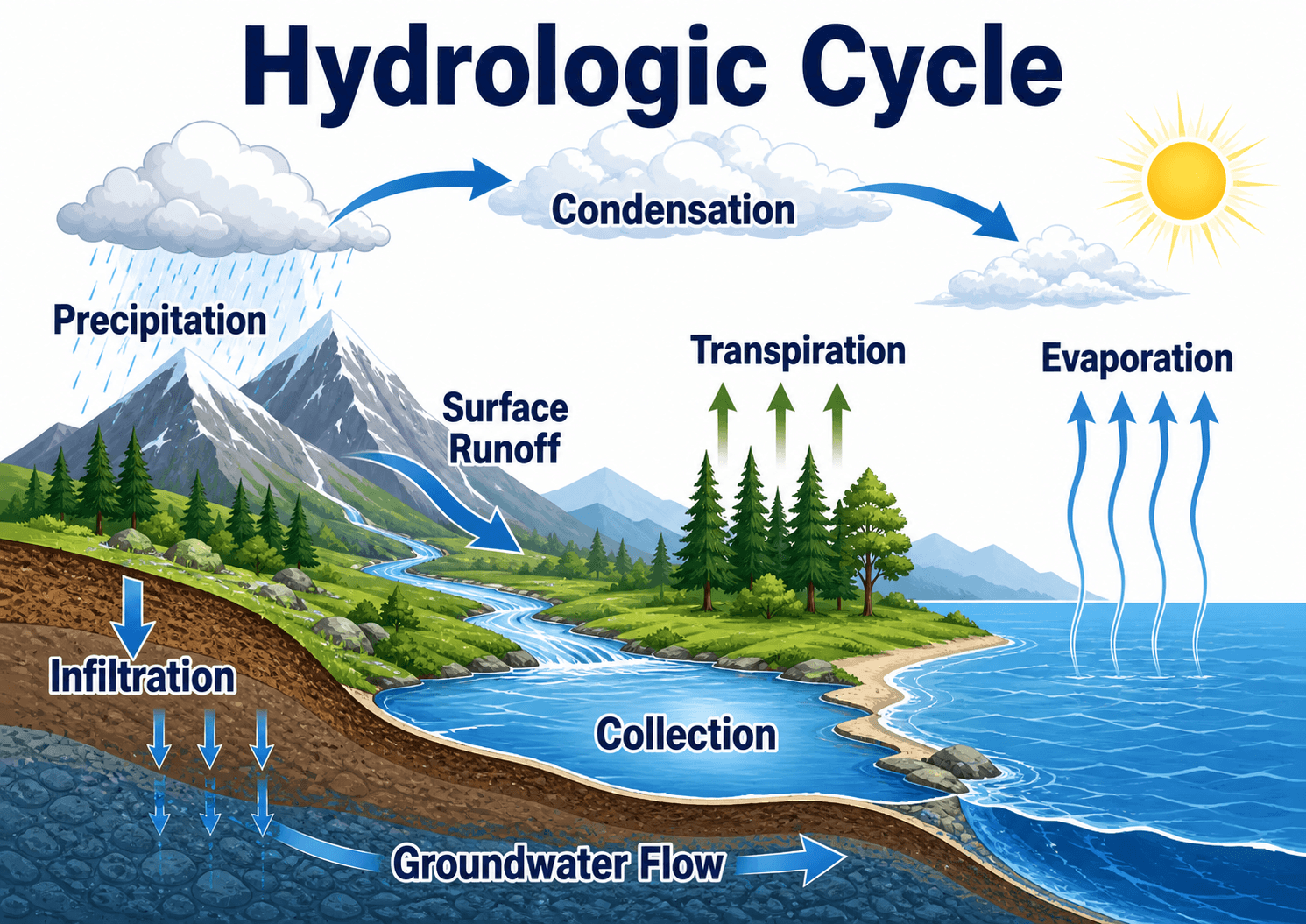
Notice that rainfall does not take one path. Some water runs off quickly, some infiltrates into soil, some recharges groundwater, some returns to the atmosphere, and some becomes streamflow after a delay.
What is Hydrology?
Hydrology is the science and engineering study of water movement, distribution, storage, and interaction with the environment. It includes precipitation, evapotranspiration, infiltration, runoff, groundwater flow, streamflow, soil moisture, snowmelt, storage, and water quality behavior across natural and built systems.
In a water resources engineering context, hydrology is the starting point for many design questions. Before an engineer can size a culvert, evaluate a detention basin, study a floodplain, estimate reservoir inflow, or assess groundwater recharge, they need a reasonable estimate of how much water is present, where it travels, and how fast it reaches the point of concern.
Hydrology is also used outside engineering. Scientists use it to study climate, drought, ecosystems, rivers, lakes, groundwater, snowpack, and long-term changes in water availability. Engineers use the same physical concepts, but usually apply them to a design or planning decision.
Hydrology estimates the amount and timing of water. Hydraulics evaluates how that water flows through channels, pipes, culverts, floodplains, pumps, spillways, and structures.
How Water Moves Through the Hydrologic Cycle
The hydrologic cycle is the physical framework behind hydrology. Solar energy drives evaporation from open water and transpiration from plants. Atmospheric processes form clouds and precipitation. Gravity moves water downslope as overland flow, through channels as streamflow, and through soil and rock as percolation and groundwater flow.
Precipitation, interception, and storage
Precipitation may fall as rain, snow, sleet, or hail. Before it becomes runoff, some of it may be intercepted by vegetation, stored in surface depressions, held in snowpack, captured by ponds or reservoirs, or absorbed into dry soil. That temporary storage is one reason two storms with the same rainfall depth can produce very different runoff responses.
Runoff, infiltration, and groundwater recharge
Runoff occurs when water moves across the land surface toward a drainage path. Infiltration occurs when water enters the soil. Some infiltrated water is held as soil moisture, some is used by plants, and some percolates deeper to recharge groundwater. Groundwater can later discharge back into streams as baseflow, which helps sustain flow between storms.
Evapotranspiration and delayed response
Evapotranspiration combines evaporation from surfaces and transpiration from vegetation. In humid, vegetated, or irrigated regions, evapotranspiration can remove a large share of available water from the system. In groundwater-dominated watersheds, the stream response may be delayed because water travels slowly through subsurface storage before reaching a channel.
Types of Hydrology
Hydrology is a broad field, so different branches focus on different parts of the water system. For engineering users, these categories help explain why one hydrologic problem may involve storm runoff while another involves aquifers, drought, snowmelt, statistics, or water quality.
| Type of hydrology | Main focus | Engineering use |
|---|---|---|
| Surface water hydrology | Runoff, streamflow, rivers, lakes, reservoirs, and watershed response. | Stormwater design, flood studies, reservoir inflow, bridge studies, and channel planning. |
| Groundwater hydrology | Recharge, aquifers, wells, seepage, baseflow, and subsurface storage. | Water supply wells, groundwater management, contamination studies, dewatering, and recharge projects. |
| Urban hydrology | Runoff from developed areas with pavement, roofs, storm drains, grading, and compacted soil. | Storm sewer sizing, detention design, flood mitigation, green infrastructure, and development review. |
| Engineering hydrology | Hydrologic analysis applied to infrastructure planning, design, permitting, and risk review. | Culverts, channels, detention basins, dams, reservoirs, floodplains, and drainage systems. |
| Statistical hydrology | Probability, frequency analysis, extremes, droughts, design storms, and recurrence intervals. | Flood frequency estimates, design storm selection, drought planning, and risk-based decision making. |
| Environmental hydrology | Water movement, water quality, ecosystems, sediment, nutrients, and watershed health. | Watershed restoration, pollutant control, stream protection, wetlands, and environmental permitting. |
Watersheds and Drainage Basin Response
A watershed, also called a drainage basin, is the land area that drains to a common outlet. Watershed hydrology focuses on how rainfall or snowmelt is partitioned into runoff, infiltration, storage, groundwater contribution, and streamflow at that outlet.
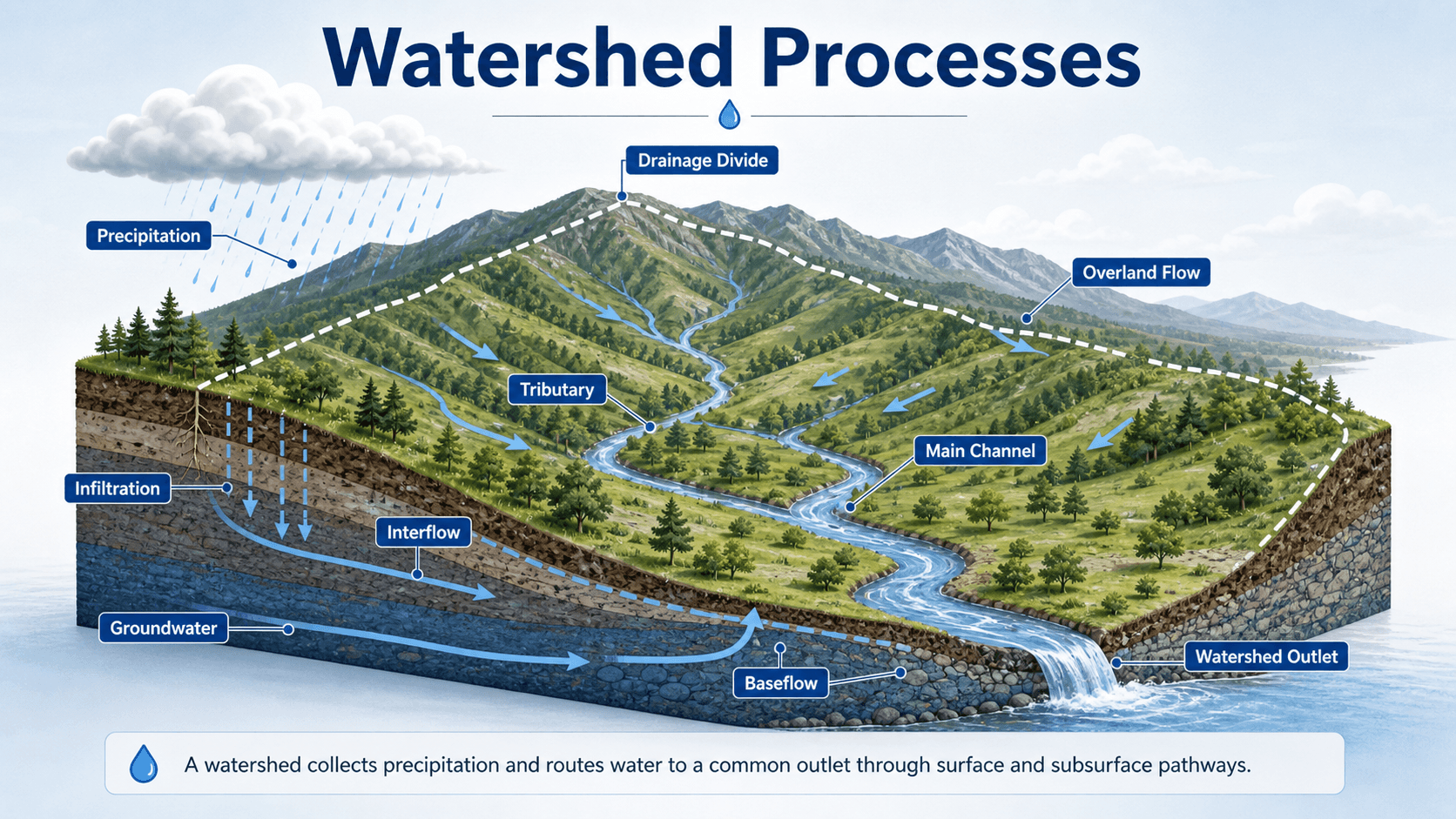
Drainage area and outlet location
The same site can produce different hydrologic results depending on where the outlet is defined. Moving the outlet downstream may add tributaries, storage, impervious area, wetlands, storm drains, or groundwater contribution. A careful watershed boundary is one of the first quality checks in any hydrologic study.
Land cover, slope, and soil conditions
Forested watersheds usually slow runoff through interception, roughness, root systems, and soil storage. Urban watersheds often respond faster because rooftops, pavement, compacted soil, and storm drains reduce infiltration and shorten travel time. Steep slopes and narrow drainage paths can also concentrate runoff quickly.
How Engineers Use Hydrology
Engineers use hydrology to convert weather, watershed, soil, land cover, and stream data into useful design or planning information. The output may be a peak discharge, runoff volume, flood frequency estimate, hydrograph, groundwater recharge estimate, reservoir inflow sequence, or water budget.
- Stormwater design: estimating runoff volume, peak flow, detention storage, drawdown time, and downstream impacts.
- Flood studies: estimating design flows, flood timing, flood frequency, channel inflows, and floodplain behavior.
- Water supply planning: evaluating reservoir inflow, watershed yield, drought reliability, aquifer recharge, and seasonal availability.
- Groundwater management: estimating recharge, discharge, pumping impacts, baseflow contribution, and long-term storage change.
- Watershed restoration: understanding how land cover, storage, stream channels, wetlands, and vegetation affect runoff and water quality.
A hydrologic result should be checked against the site scale. A small urban drainage area, a rural watershed, a reservoir basin, and a groundwater system do not respond on the same time scale or with the same dominant processes.
Key Factors That Control Runoff and Streamflow
Hydrologic response is controlled by more than rainfall depth. The same storm can produce a small delayed response in one watershed and a sharp flood peak in another because soil, slope, land cover, storage, and drainage connectivity change how water is routed.
| Factor | Why it matters | Engineering implication |
|---|---|---|
| Rainfall intensity and duration | High-intensity storms can exceed infiltration capacity and produce rapid runoff. | Controls peak discharge, inlet loading, detention sizing, culvert flow, and erosion potential. |
| Drainage area | Larger watersheds collect water from more land and may include multiple tributaries and storage zones. | Changes runoff volume, hydrograph timing, routing, and the appropriate modeling method. |
| Soil type and compaction | Sandy soils generally infiltrate faster, while clayey or compacted soils generate more runoff. | Affects curve number selection, infiltration assumptions, recharge estimates, and BMP performance. |
| Land cover and impervious area | Roofs, pavement, and compacted surfaces reduce infiltration and shorten flow paths. | Raises runoff volume, increases peak flow, and often requires detention or green infrastructure. |
| Watershed slope and shape | Steeper or more compact watersheds can deliver runoff to the outlet faster. | Influences time of concentration, lag time, and the shape of the storm hydrograph. |
| Antecedent moisture | Wet soil has less available storage than dry soil before the storm begins. | Can make a moderate storm produce a larger runoff response than expected from rainfall depth alone. |
| Surface and subsurface storage | Wetlands, ponds, depressions, reservoirs, soil storage, and groundwater storage delay water movement. | Reduces or delays peaks, changes hydrograph shape, and affects water availability between storms. |
Hydrographs and Storm Response
A hydrograph shows how streamflow or discharge changes over time. In storm hydrology, the hydrograph helps explain how a watershed converts rainfall into flow at a channel, culvert, reservoir, or design point.
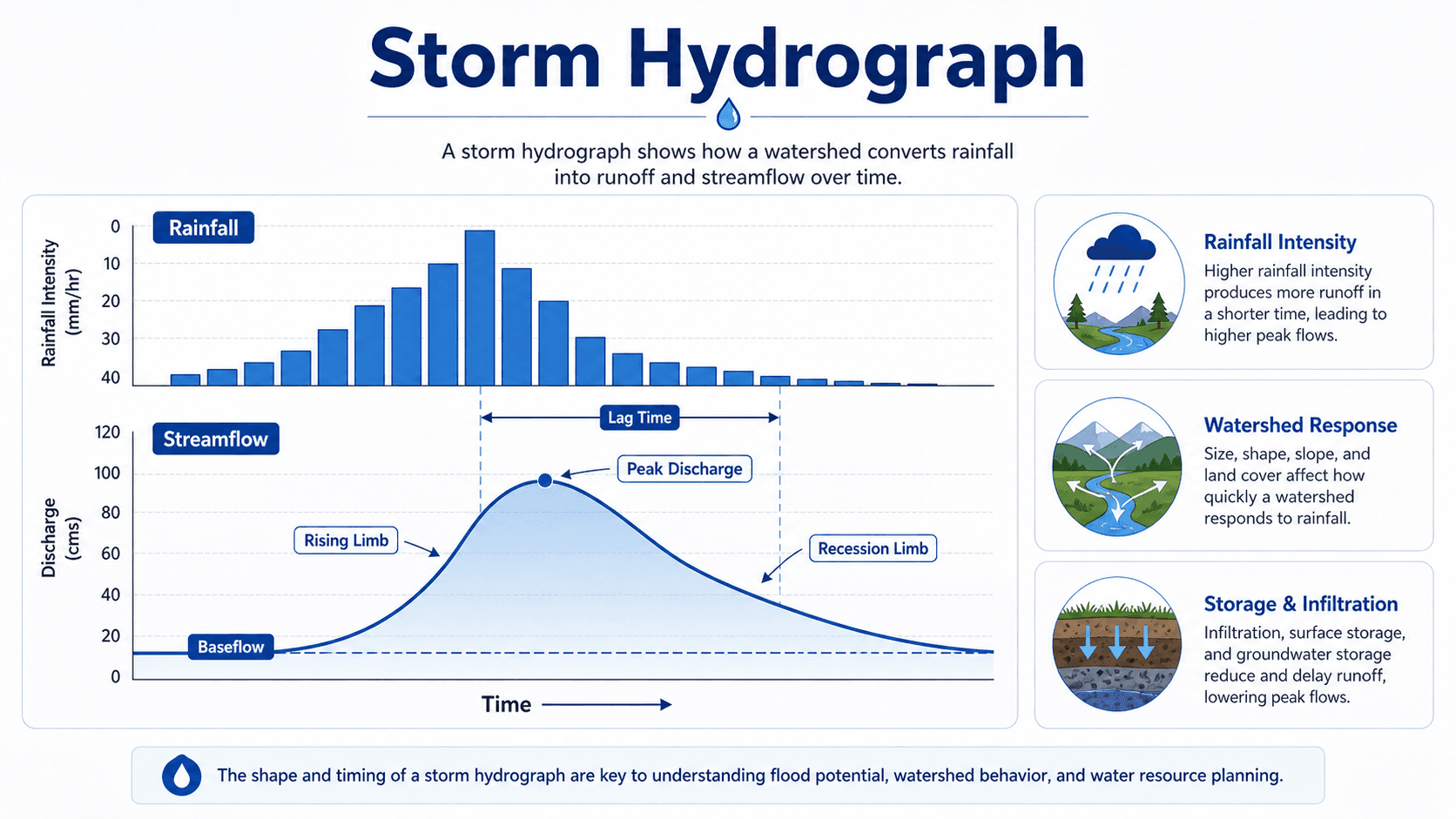
Peak discharge
Peak discharge is the maximum flow reached during a storm response. It is often the critical value for culverts, bridges, storm drains, floodplain studies, channel stability, and emergency overflow routes.
Lag time and watershed speed
Lag time is the delay between rainfall input and peak streamflow response. Short lag time usually indicates a fast, connected, or urbanized watershed. Long lag time usually indicates more storage, slower routing, flatter terrain, groundwater contribution, or larger basin scale.
Baseflow and recession
Baseflow is the portion of streamflow supported by delayed sources such as groundwater. The recession limb shows how flow declines after the storm peak. A slow recession can indicate storage release from groundwater, wetlands, reservoirs, or floodplain storage.
Water Balance, Methods, and Hydrologic Modeling
Many hydrologic studies can be simplified as a water accounting problem. Water enters a defined system, leaves through one or more pathways, or remains in storage. The challenge is defining the system boundary, choosing the time period, and estimating each term realistically.
This simplified water balance says that the change in storage, \( \Delta S \), depends on precipitation, inflow, outflow, and evapotranspiration over a selected time period. Engineers adapt this logic for watersheds, reservoirs, stormwater basins, wetlands, aquifers, irrigation systems, and water supply planning.
- \( \Delta S \) Change in storage, such as soil moisture, reservoir volume, groundwater storage, or basin storage.
- \( P \) Precipitation input, usually rainfall or snowmelt expressed as depth, volume, or rate.
- \( Q_{in} \) Surface water, groundwater, pipe, channel, or upstream inflow entering the system.
- \( Q_{out} \) Streamflow, runoff, discharge, pumping, spillway release, drainage outlet flow, or other outflow leaving the system.
- \( ET \) Evapotranspiration loss from water surfaces, soil, vegetation, and irrigated landscapes.
Common hydrologic methods
Common methods include the Rational Method for small drainage areas, runoff coefficient approaches, NRCS Curve Number methods, unit hydrograph methods, frequency analysis, continuous simulation, groundwater models, and rainfall-runoff models such as HEC-HMS or SWMM. The right method depends on the study objective, watershed size, required output, data availability, and local criteria.
| Method | Common use | Important limitation |
|---|---|---|
| Rational Method | Estimating peak discharge for small drainage areas. | Usually not appropriate for large watersheds, storage routing, or full hydrograph analysis. |
| NRCS Curve Number method | Estimating runoff depth from rainfall, soil group, land cover, and antecedent moisture assumptions. | Sensitive to curve number selection, soil condition, impervious connectivity, and calibration. |
| Unit hydrograph methods | Converting excess rainfall into a runoff hydrograph for watershed studies. | Requires reasonable watershed timing, loss, routing, and storm distribution assumptions. |
| Frequency analysis | Estimating flood or rainfall events associated with selected annual exceedance probabilities. | Depends on record length, station quality, statistical fit, and whether conditions are changing over time. |
| Continuous simulation | Modeling long-term rainfall, runoff, storage, evapotranspiration, and system performance. | Requires more input data, calibration effort, and careful interpretation than a single design storm. |
Hydrology vs. Hydraulics vs. Hydrogeology
Hydrology is closely related to hydraulics, hydrogeology, and water resources engineering, but each field answers a different question. Understanding the distinction helps prevent one of the most common beginner mistakes in water resources work.
| Field | Main question | Example engineering use |
|---|---|---|
| Hydrology | How much water is present, where does it come from, and when does it arrive? | Estimating rainfall-runoff, peak flow, hydrographs, groundwater recharge, reservoir inflow, and flood frequency. |
| Hydraulics | How does water flow through channels, pipes, culverts, floodplains, and structures? | Checking flow depth, velocity, pressure, head loss, culvert capacity, bridge openings, and flood elevations. |
| Hydrogeology | How does groundwater move through soil, rock, aquifers, fractures, and wells? | Evaluating aquifer yield, well impacts, recharge, seepage, contamination transport, and dewatering. |
| Water resources engineering | How should water systems be planned, designed, managed, and protected? | Combining hydrology, hydraulics, groundwater, water quality, infrastructure, policy, and field judgment. |
Hydrology Data Sources Engineers Commonly Use
Hydrologic analysis is only as reliable as the data and assumptions behind it. Engineers often combine public datasets with field observations because maps, models, and older studies may not fully represent current site conditions.
| Data source | What it supports | Practical check |
|---|---|---|
| Rainfall data | Design storms, intensity-duration-frequency curves, rainfall depth, and storm distributions. | Confirm the source, recurrence interval, duration, temporal pattern, and local criteria. |
| Stream gage records | Streamflow history, flood peaks, baseflow, drought behavior, and calibration checks. | Check period of record, drainage area, regulation, diversions, and land use change. |
| Topography and survey | Watershed divides, flow paths, slopes, ponding areas, channels, road crossings, and storage. | Verify that contours and survey data match current grading and drainage modifications. |
| Soil and geologic data | Infiltration, runoff potential, recharge, seepage, groundwater behavior, and storage assumptions. | Field conditions may differ from mapped data due to compaction, fill, disturbance, or seasonal water levels. |
| Land cover and aerial imagery | Impervious area, vegetation, development patterns, wetlands, agriculture, and drainage connectivity. | Use current imagery where possible because construction and development can change response quickly. |
| Field observations | High-water marks, erosion, sediment lines, clogged structures, seepage, outfalls, and overflow paths. | Use field evidence to challenge or confirm model assumptions before relying on the output. |
Hydrology Review Workflow for Engineering Studies
A good hydrologic study follows a review path before any final design flow, hydrograph, or water balance value is accepted. The workflow below helps screen whether the analysis is physically reasonable before it becomes the basis for design.
Define the outlet and study objective → delineate the watershed → select rainfall or flow data → evaluate land cover, soil, slope, and storage → choose the analysis method → estimate runoff or flow → compare against nearby records or regional expectations → adjust assumptions only when supported by field evidence or project criteria.
| Check or decision | What to look for | Why it matters |
|---|---|---|
| Watershed boundary check | Confirm drainage divides, storm drain connections, diversions, culverts, and offsite inflows. | A wrong boundary can make every runoff volume, peak flow, and hydrograph result unreliable. |
| Rainfall data check | Confirm design storm depth, duration, recurrence interval, temporal pattern, and local rainfall source. | Rainfall assumptions often control the final peak discharge and detention storage requirement. |
| Land cover check | Compare existing and proposed impervious area, vegetation, compaction, development, and drainage connectivity. | Urbanization can increase runoff volume and reduce lag time even when drainage area stays the same. |
| Soil and storage check | Review soil group, infiltration capacity, depressional storage, wetlands, ponds, reservoirs, and groundwater conditions. | Storage and infiltration determine how much rainfall becomes direct runoff and how quickly it arrives. |
| Reasonableness check | Compare results with nearby stream gages, past studies, regional regression estimates, field evidence, and known flood behavior. | Hydrologic models can look precise while still being wrong if inputs or assumptions do not match the site. |
Example: How a Storm Becomes a Design Flow
Consider a small watershed draining to a roadway culvert. The engineer is not only asking, “How much rain falls?” The engineering question is, “How much of that rain becomes runoff, how quickly does it reach the culvert, and what peak flow must the culvert safely pass?”
Step 1: Define the hydrologic system
The study begins by defining the culvert inlet as the outlet, delineating the upstream drainage area, and identifying flow paths, land cover, soil conditions, storage areas, roadway ditches, and upstream crossings. If part of the watershed drains away through a storm drain or diversion, it should not be included unless it actually reaches the culvert.
Step 2: Estimate rainfall and losses
The selected rainfall event is paired with soil and land cover assumptions to estimate losses such as infiltration, interception, and depression storage. A wooded upstream basin may produce a slower response than a compacted construction site or developed roadway corridor with connected impervious surfaces.
Step 3: Interpret the hydrograph
The result is usually a hydrograph or peak discharge. The peak affects culvert capacity, headwater elevation, roadway overtopping, erosion risk, and downstream impacts. The volume and recession shape matter for detention, erosion control, sediment transport, and downstream channel response.
Engineering Judgment and Field Reality
Hydrology is sensitive to field conditions that are easy to miss from a desktop study. A drainage divide may be altered by a roadside ditch. A wetland may store water before releasing it slowly. A clogged culvert may raise upstream water levels and change apparent flow paths. A compacted construction site may behave very differently from mapped soil data.
Experienced engineers look for evidence that confirms or challenges the model: high-water marks, sediment lines, eroded channels, ponded areas, undersized crossings, debris racks, storm drain outfalls, active seeps, groundwater-fed baseflow, floodplain storage, and land use changes since the available mapping or survey.
A clean watershed diagram can make water look predictable, but real sites include blocked inlets, undersized culverts, compacted soils, informal diversions, beaver dams, sediment buildup, groundwater seeps, and maintenance problems that can dominate the actual response.
When This Breaks Down
Basic hydrologic explanations and simplified calculations become less reliable when the system is highly connected, highly altered, poorly measured, or outside the assumptions of the selected method. In those cases, the model may still produce a number, but the number may not represent the site well.
- Extreme storms: Very rare events may exceed the range of local data, change flow paths, overwhelm storage, and activate emergency overflow routes.
- Urban drainage networks: Pipes, inlets, detention basins, pumps, and roadway grading may route water differently than natural topography suggests.
- Groundwater-dominated systems: Streamflow may depend on slow subsurface storage, seasonal groundwater levels, pumping, and aquifer-stream interaction.
- Rapid land use change: Recently developed or disturbed watersheds may not match older aerial imagery, soil assumptions, or stream gage behavior.
- Data-poor watersheds: Ungaged basins require regional estimates, assumptions, and sensitivity checks because local calibration may not be available.
Common Mistakes and Practical Checks
Hydrology mistakes often come from using a method mechanically without checking whether the inputs, watershed scale, and field conditions make sense. The most common errors are not usually math errors; they are system-definition errors.
- Confusing rainfall depth with runoff depth: Not all precipitation becomes direct runoff because interception, infiltration, storage, and evapotranspiration remove or delay water.
- Using the wrong drainage area: Missed diversions, storm drain connections, ridge breaks, or offsite inflows can distort the result.
- Ignoring antecedent moisture: A watershed that is already wet may respond much faster than one with dry soil and available storage.
- Choosing a method outside its useful range: Small-site methods, regional regression equations, and continuous models each have different assumptions.
- Treating the model as exact: Hydrologic estimates should be compared with field evidence, nearby records, historical flooding, and sensitivity checks.
The biggest hydrology mistake is accepting a peak flow just because software produced it. Always check whether the watershed, rainfall, soil, land cover, storage, routing, and outlet definition match the real site.
Relevant Manuals, Data Sources, and Design References
Hydrology relies on credible definitions, rainfall data, streamflow records, watershed observations, and project-specific design criteria. A general educational page can explain the concepts, but engineering work should be checked against local criteria, agency requirements, and accepted hydrologic data sources.
- U.S. Geological Survey: USGS Water Science School explanation of hydrology describes hydrology as the study of the occurrence, distribution, movement, and properties of Earth’s waters and connects the topic to the hydrologic cycle.
- USGS water data: USGS National Water Information System provides streamflow, groundwater, water quality, and site data that can support hydrologic review and reasonableness checks.
- NOAA precipitation frequency data: NOAA Atlas 14 precipitation frequency estimates are commonly referenced for design storm rainfall depths, durations, and annual exceedance probabilities where available.
- NRCS hydrology context: NRCS National Engineering Handbook includes hydrology guidance used in many watershed, agricultural, conservation, and runoff estimation workflows.
- Project-specific criteria: Local stormwater manuals, floodplain requirements, owner standards, transportation agency criteria, drainage ordinances, and permitting requirements may control which storms, methods, safety factors, and review checks are required.
- Engineering use: Engineers combine public data sources, field observations, hydrologic methods, and site-specific judgment to estimate runoff, streamflow, storage, groundwater recharge, and water availability for real projects.
Frequently Asked Questions
Hydrology is the study of how water moves through the environment, including precipitation, evaporation, runoff, infiltration, groundwater flow, streamflow, and storage. In engineering, it helps estimate how much water arrives, where it goes, and when it affects a site or watershed.
Hydrology is important because it provides the rainfall, runoff, streamflow, groundwater recharge, flood frequency, and water availability estimates that support stormwater design, flood studies, reservoir planning, groundwater management, water supply planning, and watershed restoration.
Hydrology estimates the amount, timing, and source of water, such as runoff from a storm or flow from a watershed. Hydraulics studies how that water moves through channels, pipes, culverts, floodplains, pumps, spillways, and other conveyance systems.
The main parts of hydrology include precipitation, evapotranspiration, infiltration, soil moisture, surface runoff, groundwater recharge, streamflow, storage, watershed response, hydrographs, and water balance. These processes work together to determine how water moves through a landscape.
Common types of hydrology include surface water hydrology, groundwater hydrology, urban hydrology, engineering hydrology, statistical hydrology, environmental hydrology, snow hydrology, and ecohydrology. Each type focuses on a different part of the water system or a different engineering use.
Engineers use rainfall data, stream gage records, topographic data, soil maps, land cover data, aerial imagery, groundwater observations, field surveys, flood records, local drainage criteria, and project-specific site observations to support hydrologic analysis.
Summary and Next Steps
Hydrology explains how water moves through the atmosphere, land surface, soil, groundwater, streams, reservoirs, and engineered systems. For water resources engineering, it is the foundation for estimating runoff, streamflow, flood risk, recharge, storage, and water availability.
The most important hydrology work is not just choosing an equation. It is defining the watershed correctly, selecting realistic rainfall and flow data, understanding field conditions, checking storage and timing, and reviewing whether the result makes sense for the site.
Where to go next
Continue your learning path with related Turn2Engineering resources.
-
Hydrologic Cycle
Review the broader natural cycle that connects precipitation, evaporation, storage, runoff, and groundwater movement.
-
Water Resources Modeling
See how hydrologic processes are represented in models for runoff, groundwater, water supply, and planning studies.
-
Stormwater Management
Learn how hydrology supports runoff control, drainage design, detention, water quality treatment, and urban flood reduction.
-
What Is Water Resources Engineering?
Step back to the full discipline and see how hydrology connects to hydraulics, infrastructure, water quality, and water management.