Key Takeaways
- Core idea: Water resources modeling uses equations, field data, maps, and computer simulations to estimate how water moves through natural and built systems.
- Engineering use: Models help engineers predict runoff, flood depth, velocity, storage, groundwater response, water quality, and infrastructure performance.
- What controls it: Rainfall, terrain, land use, soils, roughness, infrastructure geometry, boundary conditions, and calibration data strongly affect results.
- Practical check: A model should be reviewed for mass balance, sensitivity, calibration, validation, boundary conditions, and whether it answers the original engineering question.
Table of Contents
Introduction
Water resources modeling is the use of mathematical equations, field data, maps, and computer simulations to estimate how water moves through watersheds, rivers, stormwater systems, aquifers, reservoirs, and floodplains. Engineers use these models to predict runoff, flood depth, flow velocity, storage, groundwater response, and water quality so better planning and design decisions can be made.
How the Water Resources Modeling Workflow Fits Together
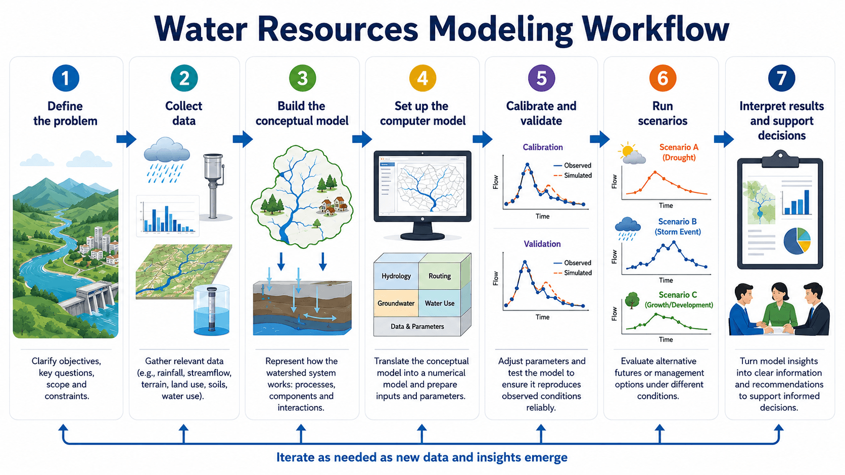
Notice that the model is not the first step. A useful model starts with the decision being made, then the data and software are selected to answer that decision as clearly as possible.
What Is Water Resources Modeling?
Water resources modeling is a structured way to represent real water systems with simplified mathematical and computational logic. A model may estimate rainfall-runoff response in a watershed, water surface elevation in a river, flood extent in a floodplain, storage in a reservoir, groundwater movement in an aquifer, or pollutant loading in a drainage system.
The value of modeling is not just that it produces maps, hydrographs, or tables. Its real value is that it helps engineers compare alternatives before decisions are built in the field. A city may test whether a detention basin reduces peak discharge, whether a culvert backs water into a road, whether future development increases runoff, or whether a drought scenario affects supply reliability.
A water resources model is a decision-support tool. It can improve engineering judgment, but it does not remove the need to check assumptions, field conditions, calibration data, and whether the selected model is appropriate for the question being asked.
Types of Water Resources Models
Water resources modeling is not one single method. Different model types answer different questions, and selecting the wrong type can lead to results that look precise but do not actually support the project decision.
| Model type | Primary question it answers | Common outputs |
|---|---|---|
| Hydrologic model | How much runoff is produced by rainfall, snowmelt, land cover, soils, and storage? | Runoff volume, peak flow, hydrograph shape, infiltration, recharge, timing, and watershed response. |
| Hydraulic model | How does water move through channels, pipes, floodplains, structures, and control points? | Water surface elevation, depth, velocity, pressure, flood extent, overtopping risk, and conveyance capacity. |
| Groundwater model | How does water move through aquifers under recharge, pumping, river interaction, and boundary conditions? | Groundwater head, drawdown, flow direction, aquifer response, baseflow interaction, and capture zones. |
| Water quality model | How do flow, runoff, mixing, treatment, residence time, and pollutant sources affect water quality? | Pollutant load, concentration, sediment transport, nutrient response, dissolved oxygen, and treatment performance indicators. |
| Reservoir or system model | How do storage, releases, demand, inflow, drought, flood control, and operating rules affect performance? | Storage levels, release schedules, reliability, shortages, spill risk, and long-term operating tradeoffs. |
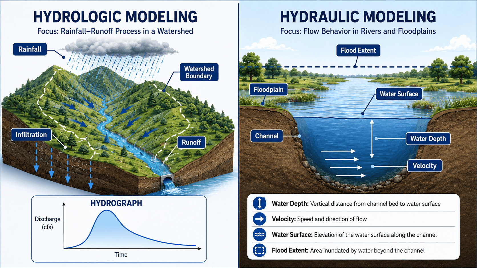
Hydrologic modeling estimates the water entering the system
A hydrologic model typically starts with rainfall, watershed area, land use, soil behavior, impervious cover, and storage. It estimates how much water becomes runoff and when that runoff reaches downstream locations.
Hydraulic modeling estimates how water moves through the system
A hydraulic model uses channel geometry, pipe networks, roughness, slopes, boundary conditions, structures, and flows to estimate water depth, velocity, flood extent, and conveyance performance. For many flood and stormwater studies, hydrologic and hydraulic models are linked together.
How to Choose the Right Water Resources Model
Model selection should follow the engineering question. The goal is not to choose the most complex software; it is to choose the simplest defensible model that represents the controlling physical behavior well enough for the decision being made.
| If the engineering question is… | Use this model type | Typical tools or approach | Main result to review |
|---|---|---|---|
| How much runoff will a storm produce from a watershed? | Hydrologic model | HEC-HMS, SWMM hydrology, watershed runoff methods | Hydrograph, peak discharge, runoff volume, and timing. |
| Where will water go during a flood or high-flow event? | Hydraulic model | HEC-RAS, SWMM routing, 1D/2D hydraulic models | Water surface elevation, depth, velocity, and flood extent. |
| Will a storm drain, culvert, or channel surcharge or overtop? | Urban drainage or hydraulic model | SWMM, hydraulic network model, culvert/channel calculations | Hydraulic grade line, ponding, surcharge, outlet control, and capacity. |
| How will pumping, recharge, or drought affect an aquifer? | Groundwater model | MODFLOW-style groundwater flow model | Groundwater head, drawdown, flow direction, and water budget. |
| How should a reservoir or supply system operate under different conditions? | Reservoir or system model | Water allocation, reservoir operations, or system simulation model | Storage, release, shortage, reliability, and flood-control tradeoffs. |
| How does runoff affect pollutant loading or receiving-water quality? | Water quality model | Stormwater quality model, watershed loading model, or treatment-train analysis | Pollutant load, concentration, removal performance, and receiving-water impact. |
If the model output does not directly support a design, planning, operations, permitting, or risk decision, the model scope should be reconsidered before more time is spent refining details.
Water Resources Model Inputs and Outputs
A model result is only meaningful if the inputs represent the real system well enough for the decision being made. A regional water planning model, a small storm drain model, a floodplain model, and a groundwater model may all use different data resolution, time steps, assumptions, and calibration targets.
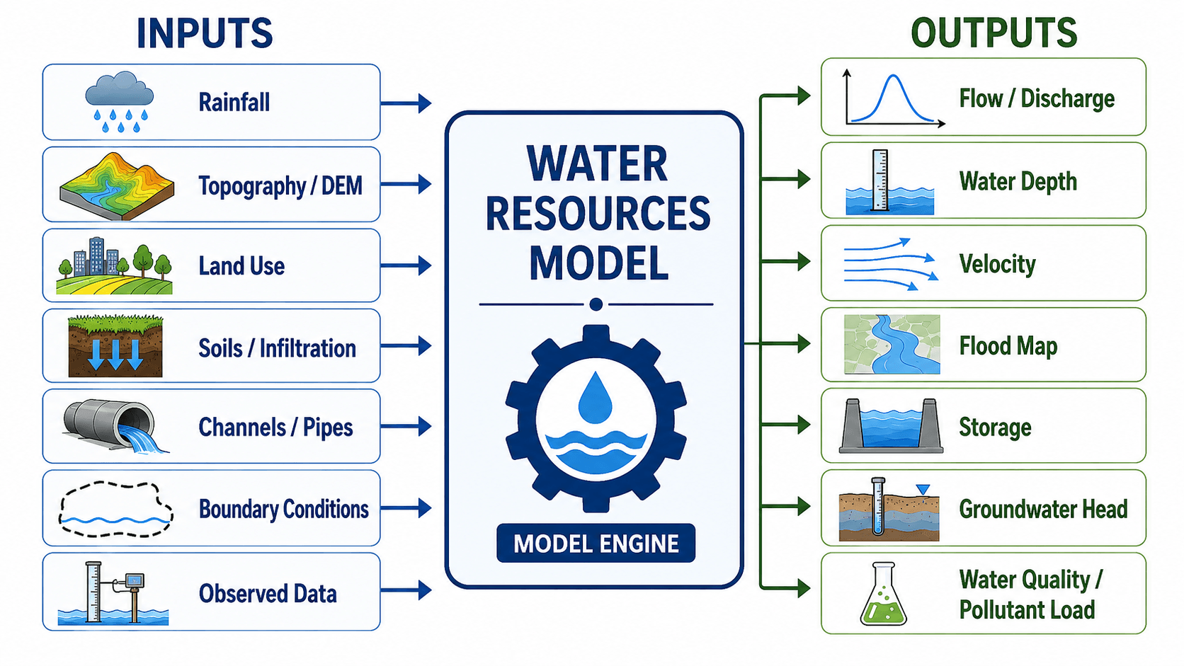
| Input or output | Why it matters | Engineering implication |
|---|---|---|
| Rainfall or inflow data | Controls the magnitude, timing, and duration of water entering the modeled system. | Changing the design storm, time step, or observed event can significantly change peak flow and storage needs. |
| Topography and drainage boundaries | Defines where water flows, where it ponds, and how drainage areas are divided. | Small terrain errors can shift flow paths, flood depths, or watershed divides, especially in flat urban areas. |
| Land use and impervious cover | Affects runoff volume, infiltration, roughness, pollutant wash-off, and hydrograph timing. | Development scenarios often increase peak flow unless storage, infiltration, or conveyance improvements are added. |
| Soils and infiltration assumptions | Controls how much rainfall becomes runoff versus infiltration or recharge. | Antecedent moisture, compaction, shallow groundwater, and soil variability can make default infiltration assumptions misleading. |
| Channel, pipe, and structure geometry | Controls hydraulic conveyance, flow depth, energy losses, surcharging, and overtopping. | A model may produce unrealistic depths if culverts, bridges, outfalls, storage, or control structures are simplified too aggressively. |
| Observed flow, stage, or groundwater data | Provides the evidence needed to calibrate and validate the model. | Without observed data, results should be treated as scenario estimates rather than confirmed predictions. |
| Modeled hydrographs, flood maps, and depths | Translate model calculations into results engineers can review and communicate. | Outputs must be checked for reasonableness, not just exported into a report or map. |
How to Interpret Water Resources Model Outputs
Model outputs should be interpreted as engineering evidence. A hydrograph, flood map, water surface profile, or groundwater head contour does not automatically explain the risk or design implication until the engineer connects it to site constraints, infrastructure limits, and decision criteria.
| Model output | What it means | Common interpretation mistake |
|---|---|---|
| Hydrograph | Flow rate over time at a point in the watershed or system. | Looking only at peak flow while ignoring total volume, timing, recession, or downstream coincidence. |
| Water surface elevation | The modeled elevation of the water surface along a channel, pipe, reservoir, or floodplain. | Confusing elevation with depth or ignoring the datum used for survey and mapping. |
| Flood depth | The vertical depth of water above ground or another reference surface. | Ignoring velocity, access, structure openings, road passability, or safety implications. |
| Velocity | The speed and direction of flowing water. | Reviewing inundation area without checking erosion, scour, hazard, or conveyance impacts. |
| Storage | The volume held in a pond, reservoir, wetland, floodplain, pipe network, or soil system. | Checking only peak storage while ignoring drawdown time, outlet behavior, and back-to-back events. |
| Groundwater head | The energy level of groundwater that indicates direction of groundwater flow and hydraulic response. | Treating sparse monitoring data as complete certainty across a heterogeneous aquifer. |
| Pollutant load or concentration | The amount or concentration of sediment, nutrients, bacteria, metals, or other constituents moving through the system. | Ignoring sampling limitations, first-flush effects, treatment performance variability, or residence time. |
How Engineers Build and Use a Water Resources Model
A practical model begins with the engineering question. The question might be, “Will this development increase downstream peak flow?”, “What roads flood during a 100-year event?”, “How does pumping affect groundwater levels?”, or “Which storage alternative reduces flood risk most effectively?”
Define the decision before choosing software
Software should be selected after the modeling objective is clear. A watershed peak-flow question, an urban drainage network, a river floodplain, and an aquifer drawdown study may require different modeling approaches.
Build a conceptual model before building the computer model
The conceptual model describes how the real system works: where water enters, where it is stored, where it exits, what controls flow, and what assumptions are being made. This step prevents the model from becoming a software exercise disconnected from field reality.
Run scenarios and interpret decisions
Once the model is set up and reviewed, engineers can compare existing and proposed conditions, design storms, future development, climate assumptions, drought periods, reservoir operations, or failure scenarios. The output should lead to a decision, not just a figure in a report.
Many modeling errors come from representing the wrong physical system, not from software limitations. A model with polished maps can still be wrong if drainage paths, tailwater, storage, roughness, or boundary conditions do not match the site.
Common Water Resources Modeling Software
Software is important, but it should not be treated as the model itself. The model includes the engineering question, conceptual assumptions, data processing, calibration, boundary conditions, scenario logic, and interpretation of results.
| Software or tool family | Common use in water resources modeling | Review focus |
|---|---|---|
| HEC-HMS | Watershed hydrology, rainfall-runoff simulation, hydrographs, losses, storage, and routing. | Check rainfall distribution, basin delineation, loss method, routing method, time step, and calibration targets. |
| HEC-RAS | River hydraulics, floodplain modeling, bridges, culverts, 1D/2D flow, and flood mapping. | Check terrain, mesh or cross sections, roughness, structures, boundary conditions, and water surface reasonableness. |
| EPA SWMM | Urban stormwater runoff, drainage networks, pipes, channels, storage, controls, and water quality routing. | Check catchment connectivity, inlet assumptions, pipe capacity, surcharge, outfalls, storage nodes, and control logic. |
| MODFLOW-style groundwater models | Aquifer flow, groundwater head, pumping drawdown, recharge, stream-aquifer interaction, and water budgets. | Check aquifer properties, recharge, pumping rates, boundary conditions, observation wells, and water balance. |
| GIS and terrain tools | Drainage area delineation, digital elevation models, land use, impervious cover, flood map display, and spatial QA/QC. | Check whether mapped drainage paths, culverts, roads, berms, grading, and field observations match the processed terrain. |
| Reservoir and water allocation models | Storage, releases, demands, drought response, operating rules, system reliability, and planning scenarios. | Check demand assumptions, inflow series, operating rules, environmental releases, shortage criteria, and scenario logic. |
The most defensible model is not always the most detailed model. A screening study, permit submittal, final design, floodplain map, groundwater investigation, and operational forecast each require a different level of detail.
Event-Based vs Continuous Modeling
Water resources models may simulate one design event or a long time series. Choosing between event-based and continuous modeling changes the required data, assumptions, calibration approach, and interpretation of results.
| Modeling approach | When it is useful | What to watch for |
|---|---|---|
| Event-based modeling | Design storms, flood checks, detention sizing, culvert review, or comparing existing and proposed conditions for a selected event. | The selected storm pattern, duration, return period, antecedent condition, and temporal distribution can strongly affect peak flow. |
| Continuous modeling | Long-term water balance, reservoir operations, groundwater recharge, drought analysis, water quality loading, and systems affected by many storms over time. | Long records require stronger data QA/QC, evaporation or evapotranspiration assumptions, seasonal behavior, and realistic storage recovery. |
Calibration, Validation, and Uncertainty
Calibration, validation, and uncertainty analysis are what separate a useful engineering model from a diagram that merely looks technical. They help determine whether the model is reproducing observed behavior and whether its assumptions are stable enough for the intended decision.
Calibration adjusts the model to observed behavior
Calibration is the process of adjusting reasonable model parameters so simulated results better match observed rainfall, streamflow, stage, groundwater head, water level, or water quality data. Calibration should not be used to force a bad conceptual model to match one event.
Validation tests the model against different data
Validation checks whether the calibrated model performs reasonably under a separate event, time period, or monitoring dataset. A model calibrated to one storm but never validated may be overfit to that event.
Sensitivity analysis shows which assumptions control the answer
Sensitivity testing changes key assumptions such as rainfall, roughness, infiltration, storage, boundary conditions, aquifer properties, or land use. If a small change in one assumption dramatically changes the result, that assumption should be documented and reviewed carefully.
| Uncertainty source | Why it affects model results | Practical review action |
|---|---|---|
| Rainfall uncertainty | Storm depth, duration, timing, and spatial variability can change peak flow and runoff volume. | Review rainfall source, event selection, time step, temporal pattern, and sensitivity to storm assumptions. |
| Terrain resolution | Small topographic features, road crowns, berms, ditches, and culverts can control shallow flow paths. | Compare model terrain to survey data, aerial imagery, plan sheets, and field observations. |
| Roughness assumptions | Vegetation, channel lining, debris, sediment, and surface condition affect velocity and water surface elevation. | Check roughness values against field condition, channel type, floodplain cover, and maintenance reality. |
| Infiltration and soil assumptions | Compaction, antecedent moisture, shallow groundwater, and soil variability change runoff and recharge. | Review soil data, field condition, land disturbance, groundwater depth, and calibration response. |
| Boundary conditions | Tailwater, outfalls, reservoirs, downstream controls, and groundwater boundaries can dominate model behavior. | Test boundary-condition sensitivity and document why each boundary condition is defensible. |
Water Resources Model Review Checklist
A model review checklist helps prevent the most common problem in water resources modeling: accepting a visually polished result without confirming that it represents the right system, uses defensible inputs, and answers the correct engineering question.
Start with the decision being made, confirm the model type fits that decision, check the input data and boundary conditions, review calibration and validation, test sensitivity, then interpret results in engineering terms before using them for design or planning.
| Model review check | What to look for | Why it matters |
|---|---|---|
| Engineering question is clear | The model is tied to a specific decision such as peak flow, flood depth, storage sizing, drawdown, or water quality load. | A model can be technically detailed but still useless if it does not answer the decision being made. |
| Model type matches the problem | Hydrologic, hydraulic, groundwater, water quality, or system-operation logic is selected for the correct physical process. | Using the wrong model type can produce outputs that look credible but do not represent the controlling behavior. |
| Inputs are traceable | Rainfall, terrain, soils, land use, geometry, roughness, and observed data have documented sources and assumptions. | Traceable inputs make the model reviewable, repeatable, and easier to update when better data becomes available. |
| Boundary conditions are defensible | Tailwater, downstream rating curves, groundwater boundaries, inflows, outfalls, and initial conditions are reviewed. | Boundary conditions can control results as much as internal model parameters, especially near outlets and control points. |
| Calibration and validation are separated | Observed data is used to tune the model, then different data or events are used to test model behavior. | Calibration alone can overfit one event; validation helps show whether the model behaves reasonably outside the tuning case. |
| Mass balance is checked | Inflow, outflow, storage, losses, recharge, and remaining volume are reviewed for reasonableness. | Mass-balance errors can reveal disconnected networks, bad units, unstable routing, or incorrect loss assumptions. |
| Sensitivity is tested | Key assumptions such as rainfall, roughness, infiltration, storage, impervious cover, or aquifer properties are varied. | Sensitivity testing shows which assumptions control the result and where uncertainty should be communicated. |
| Results are interpreted | Hydrographs, flood depths, velocity, water surface profiles, storage, head, or pollutant load outputs are translated into decisions. | Engineering value comes from interpretation, not from exporting maps or tables without explaining what they mean. |
Example: Modeling Development Impacts on a Watershed
A common use case is comparing an existing watershed condition to a proposed development condition. The engineer may need to determine whether added impervious area increases downstream peak flow and whether detention, infiltration, or conveyance improvements are needed.
Existing condition
The model begins with current drainage boundaries, land cover, soils, slopes, channels, culverts, and observed flow or rainfall data if available. The existing hydrograph becomes the baseline for understanding runoff volume, peak discharge, and timing.
Proposed condition
The proposed model updates land use, impervious cover, grading, storm drain layout, detention storage, outlet controls, and overflow routes. The engineer compares the proposed hydrograph to the existing hydrograph to see whether peak discharge, total volume, or timing changes in a way that affects downstream systems.
Engineering meaning
If the proposed condition increases the peak, shifts the hydrograph earlier, or overwhelms a downstream control point, the model helps evaluate mitigation alternatives. Those alternatives may include detention, expanded conveyance, green infrastructure, overflow routing, or changes to the site layout.
Where Water Resources Modeling Is Used
Water resources modeling is used whenever engineers need to compare how water systems behave under different events, designs, operations, or future conditions. The same general modeling logic can support planning, design, operations, risk assessment, and regulatory review.
| Application | What the model helps evaluate | Typical engineering decision |
|---|---|---|
| Stormwater drainage design | Runoff, pipe capacity, inlet performance, storage, ponding, outfalls, and peak discharge. | Size pipes, detention, channels, culverts, and overflow paths for the required design event. |
| Floodplain and river studies | Water surface elevations, flood extent, velocity, bridge backwater, levee performance, and overtopping risk. | Identify flood hazards, compare mitigation options, and evaluate impacts to upstream or downstream properties. |
| Groundwater planning | Aquifer response, pumping drawdown, recharge, baseflow interaction, and long-term groundwater availability. | Support wellfield planning, sustainability studies, dewatering reviews, and aquifer management decisions. |
| Reservoir and water supply planning | Storage, inflow, releases, demand, drought response, flood surcharge, and reliability. | Compare operating rules, drought scenarios, storage needs, and supply reliability. |
| Water quality and pollutant loading | Pollutant washoff, treatment performance, residence time, sediment, nutrients, and receiving-water impacts. | Evaluate best management practices, treatment trains, and watershed management alternatives. |
Engineering Judgment and Field Reality
Real water systems rarely behave as cleanly as a model diagram. Debris blocks culverts, vegetation changes channel roughness, sediment reduces storage, storm drains surcharge, floodplains store water unevenly, and shallow groundwater can reduce infiltration during wet periods.
Experienced engineers treat model results as evidence, not automatic truth. They compare outputs against field observations, historical flooding, known maintenance problems, survey data, aerial imagery, gauge records, and practical expectations for the site.
A model can show a system passing a design event while the actual site still floods because an inlet clogs, a downstream tailwater condition was simplified, a culvert invert was surveyed incorrectly, or overflow routes were not represented.
When Water Resources Modeling Breaks Down
Water resources modeling becomes unreliable when the simplifications in the model no longer represent the physical system or when the input data is weaker than the decision requires. The output may still look precise, but precision is not the same as accuracy.
- Poor terrain data: Flat urban areas, undersized culverts, hidden storm drains, road crowns, berms, and local grading can redirect flow in ways a coarse terrain model misses.
- Unrealistic rainfall assumptions: A design storm may not represent the timing, duration, or spatial pattern of actual storms that control the site.
- Weak boundary conditions: Tailwater, downstream control, groundwater boundaries, reservoir operation, or outfall assumptions can dominate results.
- No calibration data: Without observed flow, stage, groundwater head, or flood evidence, the model should be treated as an estimate with uncertainty.
- Wrong scale: A regional planning model may be inappropriate for inlet-by-inlet drainage design, while a detailed pipe model may be unnecessary for a screening-level watershed study.
Common Mistakes and Practical Checks
The most common mistakes in water resources modeling are not usually caused by one bad calculation. They come from mismatched model purpose, poor assumptions, unreviewed defaults, weak calibration, and overconfidence in visually polished output.
- Starting with software instead of the question: The model should be selected to answer the engineering decision, not because a tool is familiar.
- Using default parameters without review: Roughness, losses, infiltration, storage, routing, and control settings should be tied to site conditions.
- Ignoring the hydrograph shape: Peak flow matters, but timing, volume, recession, and downstream coincidence can control flooding and storage performance.
- Not checking continuity or mass balance: Flow conservation is a basic sanity check for networks, storage, routing, and water-budget logic.
- Exporting maps without interpreting risk: A flood-depth map needs engineering explanation, especially where velocity, access, structures, or emergency routes matter.
Do not treat a model as accurate just because it produces detailed graphics. A visually impressive flood map or hydrograph still needs input review, calibration checks, sensitivity testing, and field comparison.
Relevant Manuals, Data Sources, and Design References
Water resources models are often built around public rainfall, streamflow, terrain, drainage, groundwater, and water-quality data. The best reference depends on the model type, but official public documentation is especially useful when a model is tied to stormwater or drainage analysis.
- EPA Storm Water Management Model: EPA Storm Water Management Model for stormwater runoff and drainage-system modeling supports planning, analysis, and design related to stormwater runoff, combined and sanitary sewers, drainage systems, and related water-quality processes.
- Project-specific criteria: Local drainage manuals, floodplain rules, owner criteria, rainfall sources, and reviewing-agency requirements may control how a model is set up and documented.
- Engineering use: References help define accepted data sources, modeling assumptions, design events, reporting expectations, and review checks for the specific project context.
Frequently Asked Questions
Water resources modeling is the use of mathematical equations, field data, maps, and computer simulations to estimate how water moves through watersheds, rivers, stormwater systems, aquifers, reservoirs, and floodplains.
Hydrologic modeling estimates how rainfall becomes runoff, streamflow, infiltration, storage, or recharge across a watershed. Hydraulic modeling simulates how that water moves through channels, rivers, pipes, culverts, floodplains, structures, and control points.
Common water resources modeling tools include HEC-HMS for watershed hydrology, HEC-RAS for river and floodplain hydraulics, EPA SWMM for stormwater systems, MODFLOW for groundwater, and GIS tools for terrain and spatial data processing.
Common inputs include rainfall, streamflow, terrain, drainage areas, land use, impervious cover, soils, infiltration assumptions, pipe or channel geometry, boundary conditions, groundwater levels, water demands, and observed data for calibration.
A model is only as reliable as its input data, assumptions, calibration, validation, boundary conditions, and intended use. Good models support engineering decisions, but they should not be treated as exact predictions without uncertainty checks.
Summary and Next Steps
Water resources modeling helps engineers simulate how water moves through watersheds, rivers, stormwater systems, reservoirs, aquifers, floodplains, and water-quality systems. It converts rainfall, terrain, land use, soils, infrastructure, and observed data into results that can support design, planning, operations, and risk decisions.
The strongest models begin with a clear engineering question, use defensible inputs, distinguish hydrologic and hydraulic behavior, calibrate against observed conditions when possible, and document uncertainty. The model review checklist is often just as important as the software output because it helps keep the analysis tied to real field behavior.
Where to go next
Continue your learning path with related Turn2Engineering resources.
-
Hydrology
Learn how rainfall, runoff, infiltration, storage, and streamflow form the foundation of many water resources models.
-
Flood Control Measures
See how modeled flood depths, storage, conveyance, and hydrograph timing connect to flood mitigation decisions.
-
Continuity Equation
Review the flow-conservation principle behind many hydraulic checks, mass-balance reviews, and model sanity checks.