Key Takeaways
- Core idea: Floodplain management reduces flood consequences by controlling exposure, preserving flood storage, maintaining conveyance, and guiding safer development decisions.
- Engineering use: Engineers use floodplain management in watershed planning, flood studies, site design, hydraulic modeling, permitting, mitigation projects, and community resilience planning.
- What controls it: Base flood elevation, floodway limits, topography, land use, roughness, bridges, culverts, storage, tailwater, sediment, debris, and local criteria control floodplain behavior.
- Practical check: A mapped floodplain boundary is not a wall; actual risk can extend beyond the line when rainfall, terrain, development, blockage, or model assumptions change.
Table of Contents
Introduction
Floodplain management is the process of reducing flood damage by guiding how land, buildings, infrastructure, and natural flood storage areas are used in flood-prone corridors. In water resources engineering, it combines hydrology, hydraulics, mapping, regulations, mitigation, and field judgment so communities can reduce exposure instead of simply reacting after flood losses occur.
Natural Functions of Floodplains
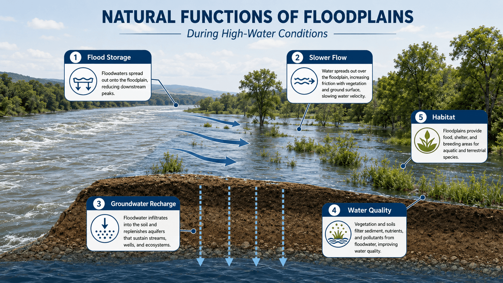
The most important idea is that a floodplain has a hydraulic job. When development removes storage or blocks flow paths, water does not disappear; it often becomes deeper, faster, or redirected somewhere else.
What is Floodplain Management?
Floodplain management is the coordinated use of maps, engineering studies, ordinances, design criteria, land-use planning, flood insurance programs, and mitigation projects to reduce damage in areas that can be covered by floodwater. It is not a single structure or a single model. It is a risk-management system that determines what can be built, how high it should be elevated, where flow paths must remain open, and where natural storage should be protected.
In water resources engineering, floodplain management sits between technical analysis and community decision-making. Hydrology estimates how much water arrives. Hydraulics estimates where that water goes, how deep it gets, and how fast it moves. Floodplain management turns that information into practical rules, project reviews, safer site layouts, and long-term mitigation priorities.
Floodplain management is broader than flood control. A levee, channel improvement, detention basin, or floodwall may reduce water levels in one location, but floodplain management also controls exposure, development location, emergency access, building elevation, future maintenance, and residual risk.
Floodplain Management vs Flood Control vs Flood Mitigation
Floodplain management is often confused with flood control and flood mitigation. The terms overlap, but they do different jobs. Floodplain management is the broader decision framework. Flood control focuses on reducing or redirecting floodwater. Flood mitigation focuses on reducing losses before the next flood occurs.
| Term | Main purpose | Typical engineering examples | How it connects to floodplain management |
|---|---|---|---|
| Floodplain management | Reduce flood exposure and guide safer use of flood-prone land. | Floodplain ordinances, development review, freeboard, floodway review, mapping, compensatory storage, open space preservation. | Provides the planning, regulatory, and engineering framework for managing flood risk over time. |
| Flood control | Physically control, store, bypass, or contain floodwater. | Levees, floodwalls, diversion channels, reservoirs, detention basins, pump stations, channel improvements. | Can be one tool within floodplain management, but it does not eliminate residual risk. |
| Flood mitigation | Reduce future flood damage to people, buildings, infrastructure, and critical services. | Elevating structures, buyouts, floodproofing, utility relocation, warning systems, nature-based storage, road improvements. | Turns floodplain risk information into projects and actions that lower consequences before the next event. |
| Flood risk assessment | Estimate likelihood, depth, velocity, exposure, vulnerability, and consequences. | Flood maps, hydraulic modeling, depth grids, damage estimates, evacuation access analysis, repetitive loss review. | Provides the technical basis for management decisions, priorities, and project selection. |
A community can have flood control structures and still have poor floodplain management if it allows risky development behind those structures, ignores maintenance, or treats mapped boundaries as permanent. Good management combines risk information, safe land use, enforceable criteria, mitigation, and long-term maintenance.
How Floodplain Management Works
Floodplain management works by connecting flood hazard information to decisions about land use, infrastructure, buildings, and mitigation. The process typically starts with rainfall, runoff, terrain, channel, and structure data. Engineers use those inputs to estimate flood elevations and flow paths. Communities then use the results to regulate flood-prone areas, review proposed development, preserve flood storage, and prioritize projects that reduce risk.
Flood hazard identification
Engineers identify flood hazards using rainfall records, stream gage data, watershed boundaries, land cover, topography, channel geometry, culverts, bridges, storage areas, and historical flood evidence. The quality of this data matters because small errors in terrain, roughness, or structure geometry can move predicted flood limits in flat areas.
Mapping and regulation
Floodplain maps translate hydraulic results into boundaries that can be used for planning and regulation. Common terms include special flood hazard area, base flood elevation, floodway, flood fringe, and freeboard. These terms help communities decide where development is restricted, where elevation is required, and where additional engineering review is needed.
Development review and mitigation
Floodplain management becomes practical when a road, subdivision, utility, building pad, bridge, or grading plan is reviewed against floodplain criteria. The review asks whether the project blocks conveyance, removes flood storage, increases flood elevations, places people in hazardous areas, or creates access and utility vulnerabilities during flood conditions.
Floodplain Cross Section: Channel, Floodway, and Flood Fringe
A floodplain cross section helps explain why not every part of the floodplain carries the same level of hydraulic importance. The river channel carries normal flow, the floodway carries the main flood discharge during larger events, and the flood fringe stores and slowly conveys water outside the highest-velocity corridor.
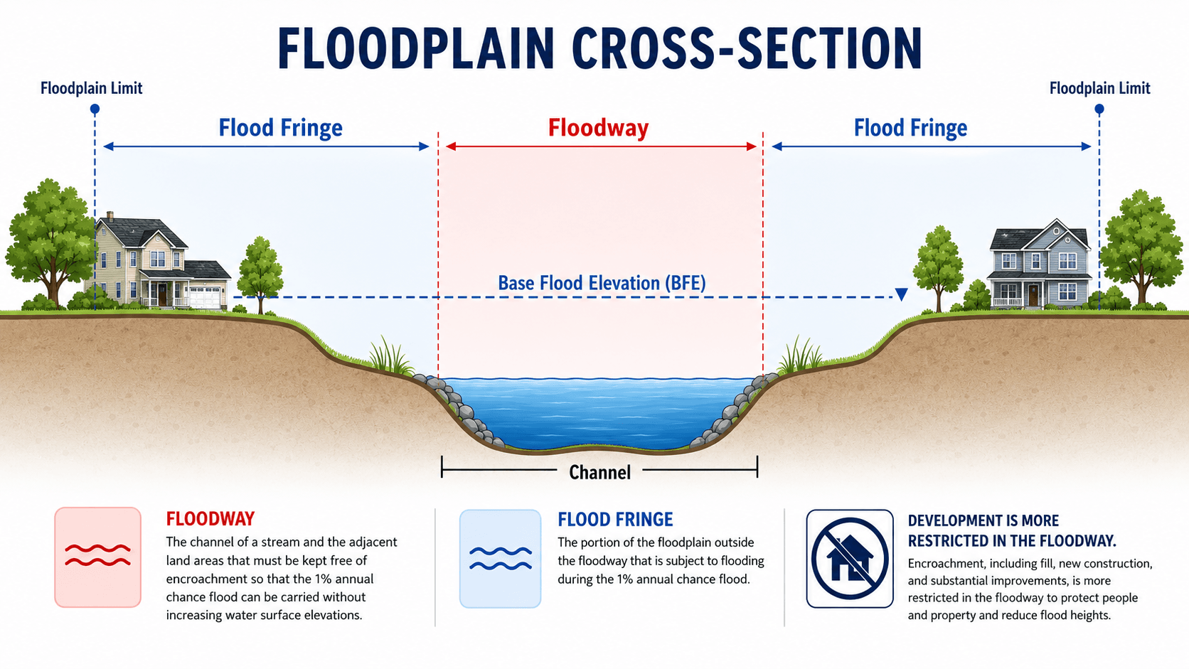
The floodway is especially important because it is tied to conveyance. Encroachment in this area can increase water surface elevations, velocities, erosion, and downstream impacts. The flood fringe may have lower velocity, but it still provides flood storage and may contain roads, utilities, structures, and evacuation routes that become vulnerable during high water.
Key FEMA and NFIP Terms Engineers Should Know
Floodplain management in the United States often uses FEMA and National Flood Insurance Program terminology. Engineers do not need to turn every article into a legal manual, but they do need to understand the terms that control mapping, development review, finished-floor elevations, insurance-related documentation, and floodplain administrator decisions.
| Term | Plain-language meaning | Why it matters in engineering review |
|---|---|---|
| Special Flood Hazard Area | The mapped area with elevated flood risk, commonly associated with the base flood. | Triggers floodplain development requirements, insurance considerations, and closer review of proposed work. |
| Base Flood Elevation | The computed water surface elevation for the base flood at a specific location. | Used to set finished floor elevations, freeboard, floodproofing levels, equipment elevations, and access checks. |
| Flood Insurance Rate Map | A FEMA map showing flood zones, floodplain boundaries, floodways, and related flood hazard information. | Used for initial screening, permitting, insurance, and determining whether deeper study is needed. |
| Floodway | The channel and adjacent land needed to carry the base flood without excessive rise. | Encroachments are highly sensitive because they can directly affect water surface elevation and velocity. |
| Freeboard | An added vertical safety margin above the required flood elevation. | Helps account for model uncertainty, wave action, future conditions, debris, and construction tolerance. |
| No-rise analysis | A hydraulic demonstration that a proposed floodway encroachment does not increase flood elevations. | Often required for projects affecting mapped floodways, bridges, culverts, grading, or fill. |
| LOMA / LOMR | Map amendment or map revision processes used to update mapped flood hazard information. | Can affect floodplain status, regulatory review, insurance requirements, and future site planning. |
| Substantial improvement or damage | A threshold concept used to determine when existing structures must meet floodplain requirements. | Important for rebuilding, renovations, post-flood recovery, and long-term risk reduction. |
The engineering takeaway is that these terms are not just paperwork. They determine what data must be reviewed, what elevations control the design, what analysis may be required, and whether a proposed project could increase flood risk for neighboring or downstream properties.
Where Engineers Use Floodplain Management
Engineers use floodplain management whenever a project interacts with rivers, streams, drainageways, mapped flood hazards, low-lying land, or stormwater overflow routes. The work often involves both calculations and judgment because flood risk depends on the interaction between water, terrain, structures, land use, maintenance, and future conditions.
- Site development review: checking building pads, grading, access roads, utilities, compensatory storage, finished floor elevations, and floodplain fill.
- Bridge and culvert projects: evaluating backwater, debris blockage, overtopping, scour potential, road closure depth, and changes to upstream flood elevations.
- Stormwater and watershed planning: preserving overflow paths, managing detention discharge, coordinating with stormwater management, and avoiding downstream peak-flow increases.
- Flood mitigation projects: comparing buyouts, elevation, floodproofing, detention, bypass channels, levees, nature-based solutions, and warning systems.
- Community planning: using flood maps and risk data to guide zoning, capital improvements, emergency access, open space, and long-term resilience decisions.
A project that is technically outside the mapped floodplain can still be flood-sensitive if it lies near an overflow path, behind undersized drainage infrastructure, downstream of a debris-prone crossing, or below a tailwater-controlled outfall.
Community Floodplain Management and Engineering Roles
Floodplain management is usually implemented at the community level, but it depends on technical information prepared by engineers, surveyors, planners, emergency managers, and public works staff. A local floodplain administrator may enforce the ordinance, while engineers provide the studies, calculations, plans, and review documents needed to support decisions.
| Role | Typical responsibility | Floodplain management value |
|---|---|---|
| Floodplain administrator | Reviews permits, applies local floodplain ordinances, coordinates documentation, and confirms required submittals. | Turns floodplain rules into consistent project-level decisions. |
| Water resources engineer | Prepares or reviews hydrologic studies, hydraulic models, no-rise analyses, drainage reports, and mitigation concepts. | Connects flood hazard data to design, permitting, and risk-reduction decisions. |
| Surveyor | Documents elevations, structure locations, finished floors, flood openings, and site topography. | Provides the elevation control needed to compare proposed construction with flood elevations. |
| Planner or zoning official | Coordinates land-use decisions, subdivision layout, open space, setbacks, and long-range development policy. | Helps prevent new exposure before engineering fixes become expensive. |
| Public works staff | Maintains channels, culverts, storm drains, roads, pump stations, and flood-prone crossings. | Keeps the physical system functioning closer to the assumptions used in design and mapping. |
| Emergency manager | Uses flood data for warning, evacuation, sheltering, road closure planning, and response coordination. | Connects floodplain information to life-safety decisions during actual events. |
What Controls Floodplain Risk?
Floodplain risk is controlled by more than the size of a storm. The same rainfall can produce different flood depths depending on watershed storage, impervious cover, channel capacity, bridge openings, floodplain roughness, downstream tailwater, sediment, debris, and how much floodplain storage has been lost to development.
| Floodplain control | Why it matters | Engineering implication |
|---|---|---|
| Base flood elevation | It estimates the water surface elevation for the base flood used in mapping and regulation. | Finished floor elevations, freeboard, floodproofing, and access planning are often tied to this elevation. |
| Floodway boundary | It identifies the area needed to convey the design flood without unacceptable rise. | Fill, buildings, walls, and obstructions in the floodway usually require more rigorous hydraulic review. |
| Floodplain storage | Storage reduces flood peaks by temporarily holding water outside the main channel. | Filling low areas can increase flood depths unless compensatory storage or other mitigation is provided. |
| Bridge and culvert capacity | Constricted openings can create backwater and raise upstream flood elevations. | Crossing design should check headwater, debris blockage, overtopping route, scour, and downstream velocity. |
| Tailwater conditions | High downstream water levels can reduce drainage capacity and back water into tributaries or storm systems. | Outfalls, detention basins, pump stations, and low roads may fail to drain even when local rainfall is moderate. |
| Future land use | Urbanization increases runoff volume and can shorten the time to peak flow. | Floodplain reviews should consider whether current maps reflect buildout conditions or outdated watershed assumptions. |
Hydrology, Hydraulics, and Mapping Methods
Floodplain management relies on both hydrologic and hydraulic analysis. Hydrology estimates the flood flow entering a channel or drainage system. Hydraulics estimates how that flow moves through the channel, floodplain, bridge openings, culverts, storage areas, and overflow paths.
The continuity relationship is not a complete floodplain model, but it captures a core hydraulic idea: discharge \(Q\) depends on flow area \(A\) and average velocity \(V\). If development, sediment, vegetation, debris, or a structure reduces effective flow area, the system may respond with higher depth, higher velocity, more backwater, or flow shifting into another path.
- \(Q\) Discharge, usually expressed in cubic feet per second or cubic meters per second. Floodplain studies often evaluate multiple return-period flows.
- \(A\) Effective flow area. Obstructions, buildings, fill, bridge piers, sediment, and dense vegetation can reduce the area available for flood conveyance.
- \(V\) Average velocity. Higher velocities can increase erosion, scour, structural risk, and safety concerns even when flood depth appears manageable.
In practice, floodplain studies may use rainfall-runoff models, statistical flow estimates, one-dimensional hydraulic models, two-dimensional hydraulic models, terrain data, field survey, land cover data, and structure inventories. The best method depends on the purpose of the study, the complexity of the floodplain, available data, and the decision being made.
How a Floodplain Development Review Usually Works
Floodplain development review is where floodplain management becomes a project-level decision. The goal is to determine whether proposed work is allowed, what conditions are required, and whether the project could increase flood risk on the site or somewhere else.
Screen the parcel against mapped flood hazards, identify the flood zone and floodway, confirm base flood elevation data, compare existing and proposed grades, review buildings and utilities, check whether fill or encroachment affects storage or conveyance, require engineering analysis where needed, document elevation or floodproofing requirements, and preserve a record for future inspections or map changes.
| Review step | What is checked | Why it matters |
|---|---|---|
| Flood hazard screening | FIRM panel, flood zone, floodway, local study data, historical flooding, and site location. | Determines whether floodplain requirements apply and whether a deeper engineering review is needed. |
| Elevation comparison | Base flood elevation, proposed finished floor, lowest adjacent grade, mechanical equipment, and freeboard. | Prevents designs that appear compliant on plan view but are too low vertically. |
| Encroachment and fill review | Floodway impacts, flood fringe fill, compensatory storage, walls, berms, fencing, and grading changes. | Checks whether the project displaces water, blocks conveyance, or raises flood elevations. |
| Access and serviceability | Road overtopping, emergency access, sanitary sewer, water service, electrical equipment, and drainage outlets. | Ensures the site is not only elevated, but usable and safer during flood conditions. |
| Documentation and conditions | Elevation certificate, drainage report, hydraulic model, no-rise certification, maintenance plan, and permit conditions. | Creates a defensible record and helps future reviewers understand the basis of approval. |
Common Floodplain Management Documents and Data Sources
Floodplain decisions are only as strong as the documents and data behind them. A good review usually combines mapped flood information, local criteria, survey data, drainage analysis, hydraulic modeling, and field observations.
| Document or data source | Used for | Why it matters |
|---|---|---|
| Flood Insurance Rate Map panel | Identifying mapped flood zones, floodplain limits, floodway areas, and initial regulatory status. | Provides the first screening layer for floodplain development review. |
| Flood Insurance Study data | Reviewing profiles, discharges, flood elevations, study methods, and mapped stream reaches. | Supports deeper interpretation beyond the map boundary alone. |
| Topographic survey | Comparing existing ground, proposed grading, finished floor elevations, and flood elevation data. | Prevents design decisions based on outdated contours or low-resolution terrain. |
| Elevation certificate | Documenting building elevations, flood openings, lowest floor, and equipment elevations. | Helps verify whether a structure meets elevation-related requirements. |
| Hydraulic model | Evaluating water surface elevations, velocity, floodway encroachment, bridge impacts, and no-rise conditions. | Tests whether proposed changes affect flood behavior. |
| Drainage report | Documenting runoff, detention, conveyance, outfalls, floodplain storage, and downstream impacts. | Connects site design to watershed and floodplain performance. |
| Field inspection notes | Recording obstructions, debris, erosion, sediment, bank condition, structure openings, and high-water evidence. | Helps catch real-world conditions that may not appear in mapping or modeling files. |
Floodplain Management Review Checklist
A useful floodplain review does not stop at “inside or outside the mapped boundary.” It checks whether the proposed condition changes flood depth, flow path, storage, velocity, access, utilities, or risk to other properties.
Confirm the mapped flood hazard, compare existing and proposed grades, identify the floodway and flood fringe, check base flood elevations and freeboard, evaluate lost storage and conveyance, review bridge or culvert controls, verify safe access, and document whether the project increases risk on-site, upstream, downstream, or across the floodplain.
| Review item | What to look for | Why it matters |
|---|---|---|
| Mapped hazard and model basis | FIRM panel, flood insurance study data, local flood studies, known flooding, terrain, and model date. | Old mapping may not reflect current rainfall, development, channel conditions, or recent infrastructure changes. |
| Base flood elevation and freeboard | Finished floor elevation, equipment elevation, lowest adjacent grade, and required safety margin above the design flood. | Small elevation differences can determine whether a structure is repeatedly damaged or remains functional. |
| Floodway encroachment | Fill, walls, buildings, fences, berms, landscaping, or grading inside the conveyance corridor. | Encroachment can increase flood levels or redirect high-velocity flow toward other properties. |
| Compensatory storage | Whether fill volume below the flood elevation is offset with equivalent usable storage nearby. | Lost floodplain storage can raise flood depths or shift water onto adjacent parcels. |
| Access and utilities | Road overtopping depth, emergency access, power equipment, sanitary sewer, water service, and storm outfalls. | A building can meet elevation criteria while still becoming isolated, unsanitary, or unsafe during a flood. |
| Maintenance and debris | Vegetation, sediment, trash racks, bridge openings, culvert inlets, erosion areas, and inspection access. | Floodplain performance often depends on what happens during the storm, not just what the design drawings show. |
Floodplain Management Tradeoffs
Floodplain management decisions often involve tradeoffs between property use, flood storage, infrastructure cost, environmental function, public safety, and long-term maintenance. A solution that appears efficient on a single parcel can create problems if it shifts water, reduces storage, blocks access, or increases maintenance requirements.
| Management choice | Potential advantage | Risk or tradeoff |
|---|---|---|
| Elevating structures | Reduces building damage without completely removing the site from use. | Access, utilities, parking, scour, and surrounding flood hazards may still be unresolved. |
| Preserving open floodplain | Maintains storage, slows water, supports habitat, and reduces future exposure. | Requires land-use discipline and may conflict with short-term development pressure. |
| Adding fill for development | Raises a building pad above expected flood levels. | Can remove storage, redirect flow, and increase flood levels unless carefully mitigated. |
| Channel modification | Can increase local conveyance and reduce frequent nuisance flooding. | May increase downstream peak timing, velocity, erosion, and maintenance burden. |
| Property acquisition or buyout | Removes repetitive-loss exposure and can restore floodplain function. | Requires funding, community support, long-term land management, and coordination with property owners. |
The strongest floodplain strategies usually combine structural and nonstructural measures. For example, detention, open space preservation, elevated critical equipment, mapped overflow routes, and development setbacks often work better together than a single isolated improvement.
Nature-Based Floodplain Management
Floodplains naturally reduce flood risk when they have room to store water, slow flow, spread energy, support wetlands, and reconnect with streams during high-water events. Nature-based floodplain management protects or restores those functions instead of relying only on hard infrastructure.
- Open space preservation: keeps high-risk floodplain areas from becoming future damage claims.
- Riparian buffers: stabilize stream corridors, filter runoff, and provide space for channel movement.
- Floodplain reconnection: allows floodwater to access storage areas that may have been cut off by berms, roads, or channelization.
- Wetland protection: supports temporary storage, water quality improvement, habitat, and slower runoff response.
- Buyouts and land conversion: remove repetitive-loss structures and convert vulnerable parcels into lower-risk community assets.
These strategies are not automatically simple. They still require grading review, maintenance planning, erosion analysis, property coordination, and an understanding of how water will move during small, moderate, and extreme events.
Why Floodplain Maps Can Change Over Time
Floodplain maps are based on data, models, and assumptions from a particular study period. They can change when the watershed changes, when better data becomes available, or when agencies update the method used to estimate flood hazards. This is one reason engineers should treat flood maps as decision tools, not as permanent descriptions of where water can and cannot go.
| Reason maps change | What changes in the analysis | Practical effect |
|---|---|---|
| Updated rainfall data | Design storms, rainfall frequency, or runoff estimates may increase or decrease. | Mapped flood elevations and floodplain extents can expand or shift. |
| New LiDAR or survey | Terrain becomes more accurate, especially in flat floodplains. | Small elevation differences can move flood boundaries across roads, lots, or building pads. |
| Urbanization | Impervious cover, runoff volume, time to peak, and drainage connectivity change. | Flood peaks may rise or arrive faster than older studies assumed. |
| Bridge or culvert replacement | Hydraulic openings, headwater, backwater, and overtopping patterns change. | Flood elevations may drop in one area while velocities or downstream impacts change elsewhere. |
| Channel erosion or sedimentation | Channel geometry, roughness, and conveyance capacity change over time. | Modeled capacity may no longer match field conditions. |
| Better 2D modeling | Flow splits, shallow overland flow, storage, and complex floodplain paths are represented more realistically. | Flood risk may appear in areas that older one-dimensional models simplified or missed. |
A site near the edge of a mapped floodplain deserves extra attention. A future map update, revised rainfall data, improved terrain, or local drainage change can move the boundary enough to affect development, insurance, access, and mitigation decisions.
Engineering Judgment and Field Reality
Real floodplains are messy. They contain fences, sheds, undersized driveway culverts, sediment bars, vegetation, utilities, eroding banks, bridge debris, undocumented grading, and land-use changes that may not appear in a model. Experienced engineers compare maps and model outputs with field evidence such as high-water marks, debris lines, scour patterns, local reports, and drainage complaints.
Floodplain management also has a time problem. Maps are snapshots of modeled conditions at the time of study, while watersheds keep changing. New pavement, upstream detention, channel maintenance, sediment deposition, bridge replacement, burned areas, deforestation, and changing rainfall patterns can all alter flood response.
A clean floodplain boundary on a map can hide uncertainty. In flat terrain, a few inches of elevation error, a blocked culvert, or an unmodeled berm can change which side of a road or property line receives floodwater.
When This Breaks Down
Floodplain management breaks down when maps are treated as perfect predictions, regulations are applied as a paperwork exercise, maintenance is ignored, or project reviews focus only on a single parcel instead of the full hydraulic system.
- Outdated maps: flood boundaries may not reflect current rainfall, development, channel conditions, or recent infrastructure changes.
- Ignored residual risk: levees, floodwalls, dams, and detention basins reduce risk but can be overtopped, bypassed, operated incorrectly, or damaged.
- Lost storage: small amounts of fill across many properties can cumulatively remove meaningful floodplain storage.
- Blocked conveyance: debris, vegetation, sediment, fences, walls, and undersized crossings can raise water levels during the event that matters most.
- False precision: modeled flood elevations can look exact, but they depend on assumptions about flow, roughness, geometry, boundary conditions, and structure performance.
Common Mistakes and Practical Checks
Floodplain mistakes usually come from treating flood risk as a line on a map instead of a physical process. Good review asks where water comes from, where it goes, how deep it gets, how fast it moves, what it carries, and what still works when the site is flooded.
- Only checking the structure footprint: access roads, parking areas, utilities, and emergency routes may fail before water reaches the building.
- Assuming fill is harmless: fill below the flood elevation can displace storage and increase flood levels if not offset or hydraulically evaluated.
- Ignoring downstream impacts: channel improvements, berms, and detention outlet changes can shift risk to other properties.
- Using a model without field review: terrain and structure data should be checked against actual crossings, bank conditions, obstructions, and maintenance realities.
- Confusing flood probability with safety: a “1-percent annual chance” flood does not mean flooding happens only once every 100 years.
The most dangerous assumption is that water stops at the mapped floodplain line. Floodplain boundaries are planning and regulatory tools, while actual flooding depends on storm pattern, drainage blockage, local grading, and changing watershed conditions.
Relevant Manuals, Data Sources, and Design References
Floodplain management uses public flood maps, local ordinances, engineering models, watershed studies, land development criteria, and mitigation planning guidance. FEMA floodplain management resources are especially important in the United States because they connect flood hazard mapping, the National Flood Insurance Program, local floodplain ordinances, minimum development standards, higher standards, and mitigation planning.
- FEMA Floodplain Management: FEMA tools and resources for floodplain management help communities understand NFIP requirements, higher standards, mitigation options, development review, and risk-reduction practices.
- Project-specific criteria: Local ordinances, state floodplain rules, drainage manuals, stormwater criteria, bridge design standards, and owner requirements can be more restrictive than minimum mapping-based requirements.
- Engineering use: Engineers use these references to check flood elevations, review proposed encroachments, document no-rise or impact analyses, select mitigation options, and coordinate with floodplain administrators.
Frequently Asked Questions
Floodplain management is the engineering, planning, and regulatory process used to reduce flood damage by managing development, preserving flood storage, guiding safe land use, reviewing flood elevations, and keeping people and infrastructure out of the highest-risk areas where possible.
A floodplain is the broader low-lying area that can be inundated during a flood, while a floodway is the portion of the channel and adjacent land needed to pass the design flood without causing excessive increases in water surface elevation. Floodway encroachment is usually more restrictive because it directly affects conveyance.
Floodplain maps can underestimate risk when rainfall data, terrain data, land use, channel geometry, structures, bridges, debris blockage, climate trends, or upstream development have changed since the model was created. A mapped boundary is a planning tool, not a guarantee that flooding stops at that line.
Engineers evaluate floodplain development by reviewing base flood elevations, floodway limits, finished floor elevations, compensatory storage, hydraulic impacts, access routes, utilities, erosion risk, local ordinance requirements, and whether the project increases flood risk on neighboring or downstream properties.
Summary and Next Steps
Floodplain management is the practical system used to reduce flood damage by combining flood mapping, land-use decisions, hydraulic review, building elevation, storage preservation, mitigation projects, and long-term maintenance. Its purpose is not only to identify where flooding may occur, but to guide decisions that reduce exposure and consequences.
The most important concepts are base flood elevation, floodway conveyance, floodplain storage, freeboard, compensatory storage, access, residual risk, map uncertainty, and changing watershed conditions. Strong floodplain management treats flooding as a physical process, not just a mapped boundary.
Where to go next
Continue your learning path with related Turn2Engineering resources.
-
Flood Risk Assessment
Learn how engineers estimate flood likelihood, consequences, exposure, vulnerability, and mitigation priorities.
-
Flood Control Measures
Compare structural and nonstructural strategies used to reduce flood depth, velocity, damage, and disruption.
-
Water Resources Modeling
Understand how models support floodplain studies, stormwater analysis, watershed planning, and hydraulic review.