Key Takeaways
- Core idea: Stormwater runoff is rainfall or snowmelt that moves across land instead of infiltrating into the ground.
- Engineering use: Runoff estimates help engineers size drainage systems, control flooding, protect receiving waters, and plan stormwater BMPs.
- What controls it: Impervious cover, soil type, slope, rainfall intensity, drainage area, storage, and inlet connectivity control runoff response.
- Practical check: The most important QA step is tracing where water actually flows during small, design, and overflow storm events.
Table of Contents
Introduction
Stormwater runoff is rainwater or snowmelt that flows across land instead of soaking into soil. In water resources engineering, runoff matters because it determines how quickly water reaches storm drains, culverts, streams, detention ponds, and low areas, affecting flooding, erosion, water quality, and drainage design.
How Land Use Changes Stormwater Runoff
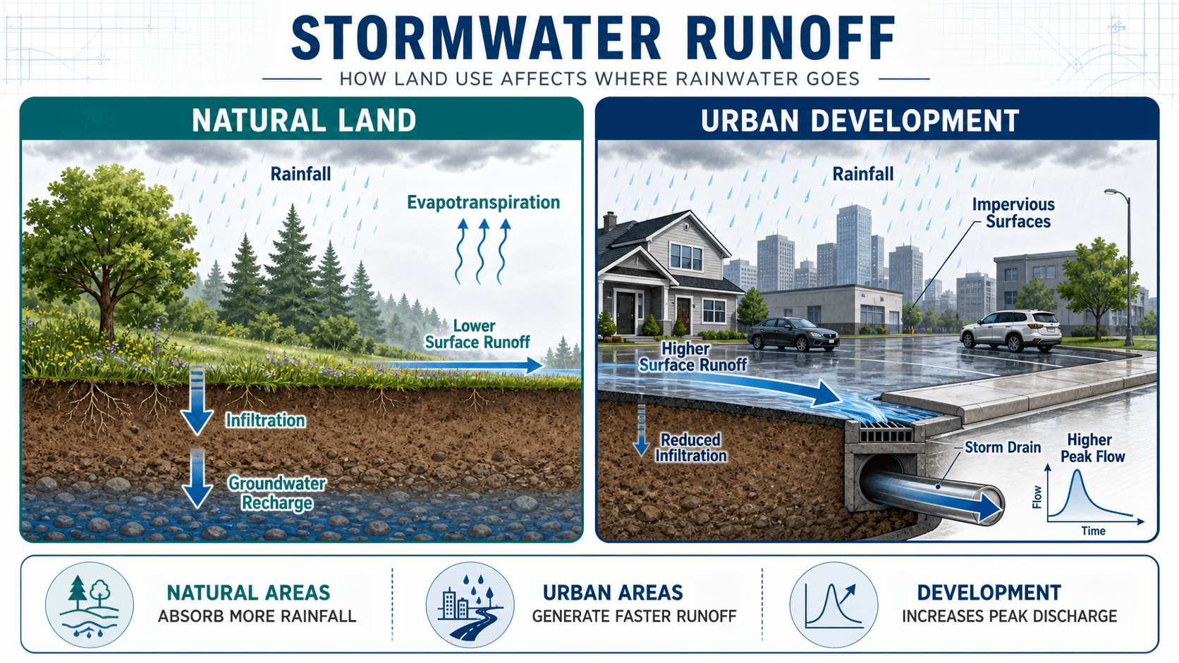
The key difference is not only how much water runs off, but how quickly it reaches the drainage system. Faster runoff can increase peak discharge, shorten response time, and raise the risk of local flooding or downstream erosion.
What Is Stormwater Runoff?
Stormwater runoff is the portion of a rain or snowmelt event that travels across the ground surface after rainfall exceeds the ability of soil, vegetation, shallow depressions, and constructed features to absorb or store water. It can start as shallow sheet flow, collect in gutters or swales, enter storm drain inlets, or discharge directly toward ditches, ponds, streams, wetlands, or other receiving waters.
In a natural watershed, rainfall is divided between interception, infiltration, evapotranspiration, groundwater recharge, depression storage, and streamflow. In a developed watershed, rooftops, pavement, compacted soil, and connected drainage systems shift more water into faster surface flow. That shift is why runoff is one of the core concepts behind stormwater management, stormwater drainage design, and urban flood control.
Stormwater is the water from rain or snowmelt. Stormwater runoff is the portion that moves across the surface. Stormwater management is the engineering process used to control, convey, store, infiltrate, treat, or safely release that runoff.
How Stormwater Runoff Moves Through a Developed Site
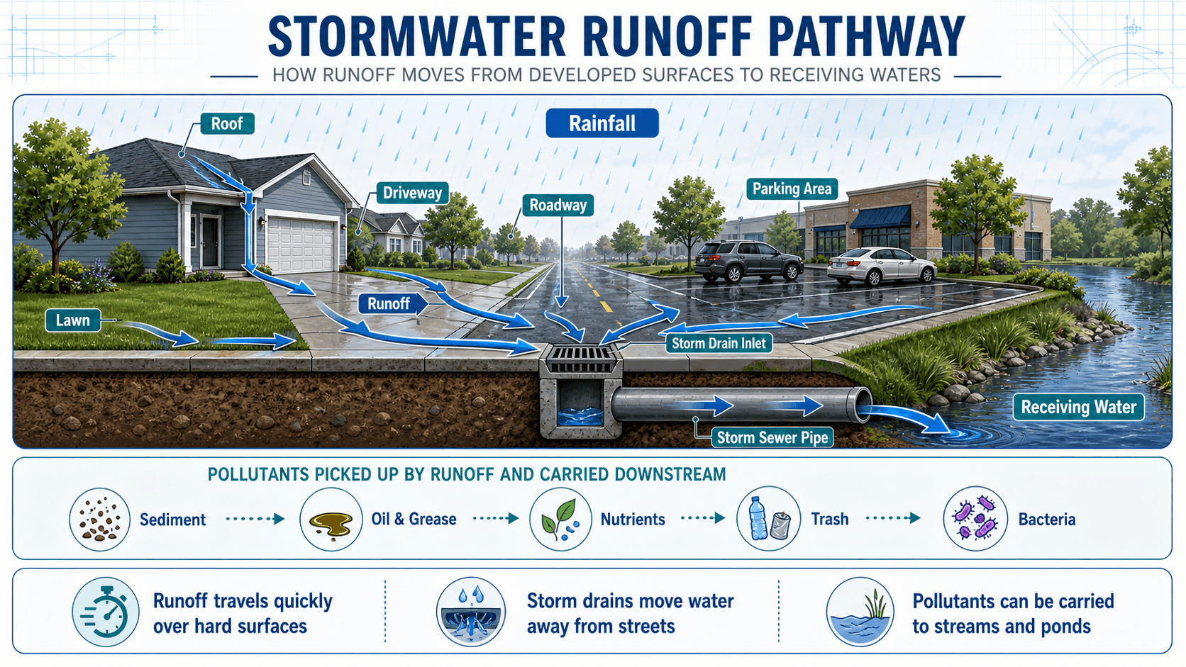
Runoff begins where rainfall lands on a surface that cannot absorb water quickly enough. On developed sites, roofs, driveways, sidewalks, streets, parking lots, compacted lawns, and graded slopes may all send water toward the same inlet, swale, curb line, ditch, basin, or low point. Once runoff reaches a connected drainage system, travel time can become very short.
Runoff is shaped before it reaches the pipe
A drainage problem often begins upstream of the inlet. Pavement slope, roof leaders, curb cuts, driveway crowns, landscape berms, and surface depressions can change where water goes. A pipe calculation may be correct and still miss the real problem if the surface flow path is wrong.
Connected impervious area changes timing
Not all impervious area creates the same runoff response. A roof draining onto a lawn may allow some infiltration and delay. A roof draining to a driveway, gutter, and curb inlet sends water quickly to the storm sewer. Engineers often care about connected impervious area because it influences peak flow, pollutant delivery, and the effectiveness of green infrastructure.
Why Stormwater Runoff Matters
Stormwater runoff matters because it links land development to drainage capacity, flood risk, stream stability, water quality, infrastructure maintenance, and downstream impacts. A site that drains poorly may flood locally. A site that drains too quickly may simply transfer the problem to a downstream ditch, culvert, stream, or neighborhood.
- Drainage capacity: Runoff estimates support inlet, pipe, channel, culvert, and outfall sizing.
- Flood management: Faster runoff can increase peak discharge and reduce the time available for drainage systems to respond.
- Water quality: Runoff can carry sediment, nutrients, oil, bacteria, metals, chloride, and trash to receiving waters.
- Erosion control: Concentrated runoff can scour channels, destabilize banks, damage slopes, and undermine outfalls.
- Site planning: Runoff patterns influence grading, inlet placement, detention design, overflow routing, and BMP selection.
A stormwater review should not only ask, “Can the pipe carry the flow?” It should also ask where the water comes from, how fast it arrives, what happens if the inlet clogs, and where excess runoff goes when the design storm is exceeded.
Key Factors That Control Stormwater Runoff
Runoff is controlled by the interaction between rainfall, land cover, soil, slope, storage, and drainage connectivity. Two sites with the same rainfall depth can produce very different runoff because one site may absorb, delay, or store water while the other routes it quickly to a storm drain.
| Factor | Why it matters | Engineering implication |
|---|---|---|
| Impervious cover | Roofs, roads, sidewalks, and parking lots reduce infiltration and increase surface flow. | Higher impervious cover usually increases peak discharge and may require more conveyance, storage, or treatment. |
| Connected impervious area | Direct connections to inlets and pipes reduce opportunities for infiltration or filtering. | Disconnected drainage to vegetation, swales, or infiltration areas can reduce effective runoff and improve water quality. |
| Soil type and compaction | Sandy, uncompacted soils may accept more water, while clayey or compacted soils infiltrate slowly. | Mapped soil data should be checked against field conditions, especially after grading or construction traffic. |
| Rainfall intensity and duration | Short intense storms can overwhelm inlets and shallow flow paths even when total rainfall depth is moderate. | Drainage design must match the design storm, local criteria, and response time of the drainage area. |
| Slope and roughness | Steeper, smoother flow paths move runoff faster than flat, vegetated, or rough surfaces. | Travel time and time of concentration influence peak flow, inlet timing, and hydrograph shape. |
| Surface storage | Depressions, landscaping, ponds, and low areas temporarily hold water. | Storage can reduce or delay peak flow, but it must include a safe overflow route when capacity is exceeded. |
Stormwater Runoff and Water Quality
Stormwater runoff is also a water quality issue. As runoff travels over developed surfaces, it can pick up sediment from bare soil, oil and grease from pavement, nutrients from fertilizer, bacteria from pet waste, metals from vehicle wear, trash from streets, and other pollutants. If the drainage system moves that runoff directly to receiving waters, there may be little opportunity for filtering or treatment.
First flush can be important
The early portion of a storm can carry a concentrated pollutant load because it washes accumulated material from roads, roofs, parking lots, and landscaped areas. This is one reason water quality BMPs often focus on smaller frequent storms rather than only extreme flood events.
Sediment is both a pollutant and a maintenance problem
Sediment can cloud receiving waters, carry attached pollutants, fill forebays, clog permeable surfaces, reduce basin storage, and block inlets. A stormwater practice that is not maintainable may lose water quality performance over time even if the original design concept was sound.
How Engineers Estimate Stormwater Runoff
Engineers estimate stormwater runoff by defining the drainage area, selecting a design storm, evaluating land cover and soil conditions, estimating travel time, and choosing a method appropriate for the site scale. For small drainage areas, peak flow methods are common. For larger or more complex watersheds, hydrographs, storage routing, and hydraulic modeling may be needed.
The Rational Method is a common small-site peak flow relationship where \(Q\) is peak discharge, \(C\) is a runoff coefficient, \(i\) is rainfall intensity, and \(A\) is drainage area. In U.S. customary practice, \(Q\) is commonly expressed in cubic feet per second when \(i\) is in inches per hour and \(A\) is in acres because the unit conversion is approximately one.
- Q Peak runoff rate, commonly expressed in cubic feet per second or cubic meters per second.
- C Runoff coefficient representing how much rainfall becomes runoff for the selected land cover, soil condition, and connectivity.
- i Rainfall intensity for a selected storm duration and recurrence interval.
- A Drainage area contributing to the inlet, pipe, culvert, channel, pond, or outfall being evaluated.
Peak flow is not the whole design
Peak flow helps size conveyance features, but stormwater design often also needs runoff volume, hydrograph timing, pollutant load, downstream tailwater, emergency overflow capacity, and drawdown time. A detention basin is not designed only around the highest flow rate; it also depends on how much water arrives, how quickly it is released, and how long it remains stored.
How Stormwater Runoff Is Managed
Stormwater runoff is managed with a treatment train of practices that may collect, convey, store, infiltrate, filter, slow, or release water. The right approach depends on site area, soils, groundwater, topography, available space, pollutant concerns, maintenance access, and local drainage criteria.
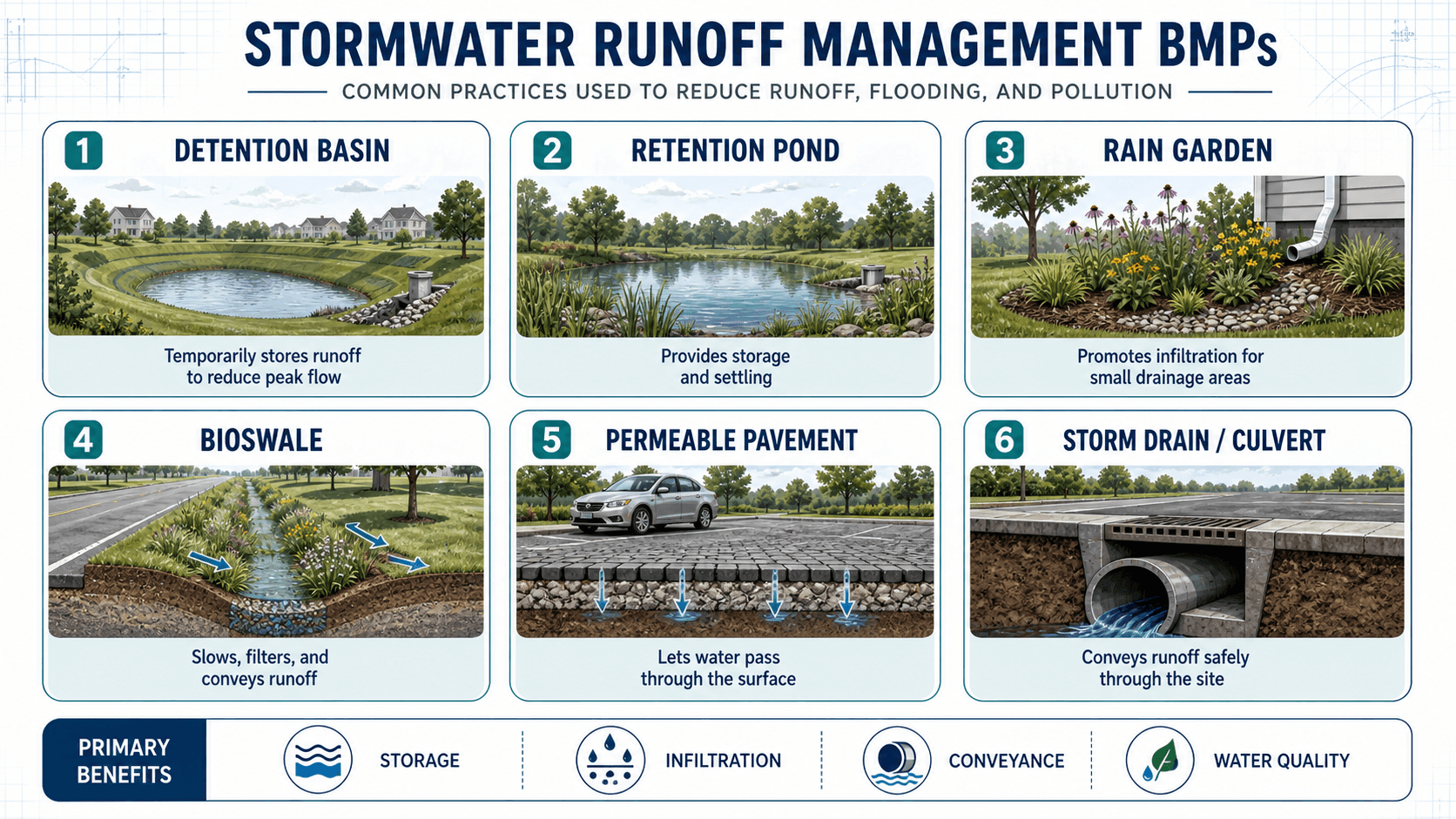
Gray infrastructure moves runoff safely
Storm drains, culverts, channels, inlets, and outfalls are conveyance systems. Their main job is to move runoff away from streets, buildings, and critical areas without causing unsafe ponding, excessive velocity, erosion, or downstream flooding.
Green infrastructure slows and filters runoff
Green infrastructure, rain gardens, bioswales, permeable pavement, and vegetated areas can reduce runoff volume, slow flow, and improve water quality when soils, slopes, groundwater, and maintenance conditions are suitable. These practices work best when runoff can actually reach them and when overflow paths are planned.
Storage practices reduce peak flow
Detention basins and stormwater retention ponds are used to store runoff and reduce the rate at which water leaves a site. Detention temporarily stores and releases water, while retention ponds usually maintain a permanent pool that can support settling and water quality benefits.
Urban Stormwater Runoff
Urban stormwater runoff is runoff shaped by dense impervious cover, curb-and-gutter streets, storm sewer networks, compacted soils, and limited open space. Compared with natural drainage, urban systems often produce faster runoff, higher peak flows, more frequent nuisance ponding, and greater pollutant transport.
This is why urban stormwater management focuses on both conveyance and source control. A good urban strategy may include inlet improvements, detention storage, green infrastructure, street sweeping, outfall protection, flood routing, redevelopment standards, and maintenance programs.
In dense areas, the limiting factor is often not the ability to identify a BMP. It is finding enough space, grade, soil capacity, maintenance access, and overflow protection to make the BMP reliable.
Stormwater Runoff Review Workflow
A strong runoff review follows the water from rainfall to discharge. The goal is to confirm that the analysis describes the real site, not just a simplified drawing, spreadsheet, or software model.
Define the drainage area → map the flow paths → identify impervious and pervious surfaces → estimate rainfall and runoff response → check inlets and conveyance → evaluate storage and overflow → review downstream impacts → confirm maintenance access and water quality controls.
| Check or decision | What to look for | Why it matters |
|---|---|---|
| Drainage boundary | Confirm that the mapped area actually drains to the inlet, culvert, pond, or outlet being analyzed. | A wrong boundary can make the runoff estimate too high, too low, or assigned to the wrong location. |
| Flow path connectivity | Look for roofs, driveways, curb cuts, gutters, swales, and paved areas directly connected to storm drains. | Connected surfaces can increase peak flow and reduce water quality treatment opportunities. |
| Low points and overflow | Identify where water goes if an inlet clogs, a pipe surcharges, or rainfall exceeds the design storm. | Safe overflow routes often control real-world flood risk more than the normal pipe design does. |
| Soils and compaction | Compare mapped soils with field evidence such as ponding, construction fill, clay lenses, or compacted subgrade. | Infiltration-based controls can underperform if the assumed soil condition is unrealistic. |
| Downstream capacity | Check whether the receiving ditch, channel, culvert, pond, or stream can handle the changed runoff pattern. | A site can meet local conveyance needs while still worsening downstream erosion or flooding. |
Design Tradeoffs in Runoff Control
Stormwater runoff control is rarely a single-objective problem. A practice that is excellent for peak flow reduction may be weak for water quality. A practice that infiltrates runoff may not work on tight clay soils or where groundwater is shallow. A practice that looks efficient on plans may fail if maintenance access is poor.
| Design goal | Useful practices | Tradeoff to check |
|---|---|---|
| Reduce peak discharge | Detention basins, underground storage, controlled outlets, distributed storage. | Storage must release water slowly enough to reduce peaks without causing long-duration ponding or downstream timing issues. |
| Improve water quality | Bioretention, rain gardens, bioswales, forebays, wet ponds, vegetated filters. | Treatment only works if runoff enters the practice, residence time is adequate, and sediment can be maintained. |
| Reduce runoff volume | Infiltration basins, permeable pavement, soil restoration, disconnected impervious area. | Soils, groundwater, clogging, slope, and winter conditions can limit reliable infiltration. |
| Protect structures and streets | Storm drains, culverts, curb inlets, channels, overland relief routes. | Conveyance moves water efficiently, but it may also transfer peak flow and erosion risk downstream. |
The best runoff solution often combines small upstream source controls with downstream conveyance and storage. This reduces dependence on one oversized feature and improves resilience when part of the system clogs or underperforms.
Engineering Judgment and Field Reality
Stormwater runoff diagrams are clean, but real sites are messy. Curbs settle, inlets clog, landscaping changes, trash accumulates, soil compacts, and private drainage modifications can redirect flow. A paved surface that appears to drain one way on aerial imagery may send water somewhere else because of curb breaks, driveway crowns, localized grading, or settlement.
Experienced engineers look for physical evidence: sediment lines, ponding stains, eroded grass, displaced mulch, undermined riprap, cracked pavement near inlets, debris at grates, and high-water marks. These field clues can reveal flow paths that are missing from the plan set.
The design storm is not the only storm that matters. Frequent smaller storms often drive water quality, maintenance, nuisance ponding, and erosion complaints, while extreme storms reveal whether overflow routes are safe.
When This Breaks Down
Simplified stormwater runoff assumptions break down when the site behavior is controlled by storage, backwater, clogged infrastructure, groundwater, changing land use, or unusual storm patterns. In those cases, a simple peak flow estimate may not describe the real drainage problem.
- Backwater and tailwater: A pipe or ditch may have capacity on paper but fail to drain when the downstream water surface is high.
- Clogged inlets and debris: Leaves, sediment, trash, snow, or construction material can reduce inlet capacity and shift runoff to streets or buildings.
- Compacted or disturbed soils: Post-construction soils may infiltrate far less water than mapped soil data suggests.
- Disconnected models: A model may show a clean flow path while the field site contains curb breaks, walls, landscaping, or settlement that redirects runoff.
- Changing land use: Older drainage systems may not reflect current impervious cover, local criteria, or rainfall assumptions.
Common Mistakes and Practical Checks
The biggest stormwater runoff mistakes usually come from treating runoff as a simple calculation instead of a physical site response. Good analysis combines maps, equations, field observations, drainage criteria, and engineering judgment.
- Assuming all grass is highly permeable: Compacted lawns, clay soils, and shallow groundwater can produce significant runoff.
- Ignoring overland relief: Inlets and pipes can clog or surcharge, so emergency surface flow paths must be understood.
- Using one runoff coefficient for a mixed site: Roofs, pavement, landscaped areas, and wooded areas usually respond differently.
- Focusing only on peak flow: Runoff volume, duration, pollutant delivery, erosion potential, and drawdown time may control the design.
- Forgetting downstream impacts: Moving water off one site faster can worsen flooding, erosion, or water quality elsewhere.
Do not assume that routing runoff quickly to the nearest storm drain solves the problem. It may simply move flooding, erosion, or pollutant loading downstream.
Useful References and Design Context
Stormwater runoff design should combine hydrologic analysis, site observations, local stormwater criteria, and accepted public guidance. General runoff concepts are useful for learning, but final design decisions usually depend on local drainage manuals, permitting requirements, owner criteria, and site-specific constraints.
- U.S. Environmental Protection Agency: EPA Urbanization and Stormwater Runoff explains how rain and snowmelt move over impervious surfaces, how runoff can carry pollutants, and why urban development changes runoff behavior.
- Project-specific criteria: Local stormwater manuals, municipal ordinances, transportation agency criteria, floodplain requirements, and permit conditions may control design storms, allowable release rates, water quality volume, detention requirements, and maintenance responsibilities.
- Engineering use: Engineers use runoff guidance to select methods, define drainage areas, estimate peak flow and volume, evaluate BMP performance, and check whether the proposed drainage system protects both the site and downstream receiving waters.
Frequently Asked Questions
Stormwater runoff is rainwater or snowmelt that flows across land instead of soaking into the ground. In developed areas, it often travels over rooftops, roads, sidewalks, parking lots, driveways, and lawns before reaching storm drains, ditches, streams, detention ponds, or other receiving waters.
Stormwater runoff is caused when rainfall exceeds the ability of soil, vegetation, depressions, and drainage features to absorb or store water. Impervious surfaces, compacted soil, steep slopes, intense rainfall, and directly connected storm drains usually increase both the amount and speed of runoff.
Stormwater runoff becomes a problem when it causes flooding, erosion, infrastructure overload, or pollution. Runoff can move quickly across hard surfaces, carry sediment and pollutants, enter storm drains with little treatment, and discharge to streams or ponds faster than the receiving system can handle.
Engineers reduce stormwater runoff problems by combining conveyance, storage, infiltration, water quality treatment, and overflow planning. Common approaches include storm drains, culverts, detention basins, retention ponds, bioswales, rain gardens, permeable pavement, site grading, and green infrastructure.
Summary and Next Steps
Stormwater runoff is the portion of rainfall or snowmelt that moves over the land surface instead of infiltrating into the ground. In water resources engineering, it is a core concept behind drainage design, flood management, storm sewer capacity, detention storage, water quality treatment, and urban watershed planning.
The most important runoff questions are physical: where does the water come from, how quickly does it reach the outlet, what pollutants does it carry, where does it go if the normal system fails, and how does the site affect downstream conditions?
Where to go next
Continue your learning path with related Turn2Engineering resources.
-
Stormwater Management
Learn how runoff is controlled through conveyance, storage, infiltration, green infrastructure, water quality treatment, and overflow planning.
-
Stormwater Drainage Design
See how runoff estimates are applied to site grading, inlets, pipes, channels, culverts, detention, and drainage system layout.
-
Hydrology
Build the broader foundation for rainfall, infiltration, runoff, streamflow, hydrographs, watersheds, and water balance.