Key Takeaways
- Core idea: Flood control measures reduce flood consequences by storing water, moving it safely, keeping it away from exposed assets, or reducing the damage when water exceeds the system.
- Engineering use: Engineers use flood control measures in watershed planning, stormwater design, river studies, dam and levee work, bridge hydraulics, emergency planning, and floodplain management.
- What controls it: Rainfall intensity, runoff volume, watershed response, channel capacity, tailwater, storage, land use, sediment, debris, maintenance access, and downstream impacts control the best solution.
- Practical check: A flood control measure is not successful just because it protects one site; it must also consider residual risk, overtopping, failure modes, operations, maintenance, and who may be affected downstream.
Table of Contents
Introduction
Flood control measures are engineering, planning, and operational strategies used to reduce flood damage by managing where water goes, how fast it moves, how much can be stored, and which people or assets remain exposed. Effective flood control combines hydrology, hydraulics, infrastructure design, land-use decisions, warning systems, and long-term maintenance.
Flood Control Measures Diagram
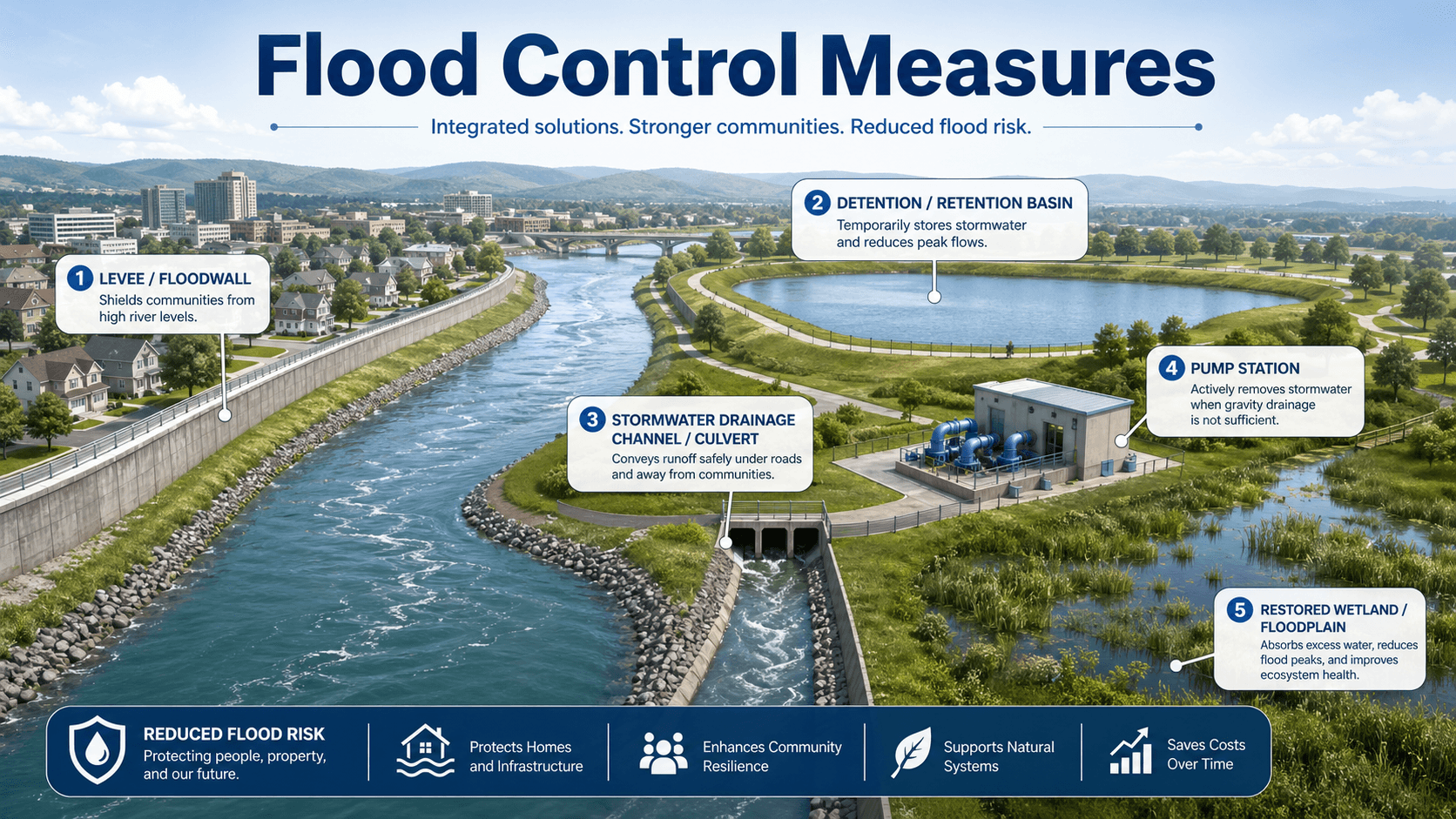
Read the diagram from watershed to community. Rainfall becomes runoff, runoff moves toward channels and drainage systems, and flood control decisions determine whether water is detained, diverted, contained, passed downstream, or allowed to occupy a lower-risk floodplain area.
What are Flood Control Measures?
Flood control measures are the physical structures, planning tools, operating rules, and risk-reduction strategies used to limit damage from river flooding, stormwater flooding, coastal surge, dam releases, or overwhelmed drainage systems. They can be structural, such as levees and detention basins, or nonstructural, such as floodplain zoning and warning systems.
In water resources engineering, the goal is not always to eliminate flooding. That is rarely realistic. The more practical goal is to reduce flood depth, velocity, duration, exposure, and consequence. A well-designed flood control strategy accepts that extreme events can exceed the design condition and still tries to fail in a predictable, manageable, and less damaging way.
Flood control is a risk management problem, not just a construction problem. A bigger wall, deeper channel, or larger basin may help one location while increasing velocity, erosion, cost, maintenance burden, or downstream flood levels somewhere else.
How Flood Control Measures Work
Flood control measures work by changing one or more parts of the flood process: the amount of runoff produced, the timing of the peak flow, the available storage volume, the hydraulic capacity of the flow path, the exposure of buildings and infrastructure, or the warning time available before flooding occurs.
Storage reduces peak flow
Detention basins, reservoirs, wetlands, floodplain storage, and some green infrastructure systems temporarily hold water so less flow arrives downstream at the same time. Storage is especially useful when a watershed produces a short, intense runoff peak that would otherwise overwhelm a channel, culvert, bridge opening, or storm drain network.
Conveyance moves water through a controlled path
Channels, culverts, storm sewers, bridge openings, spillways, and floodways are conveyance measures. They do not remove the flood volume; they provide a path for moving water through or around a vulnerable area. Conveyance improvements must be checked carefully because increasing capacity upstream can transfer higher flows, higher velocities, or higher water levels downstream.
Barriers separate floodwater from exposed assets
Levees, berms, floodwalls, gates, and temporary barriers are used where water must be kept away from buildings, roads, utilities, or critical facilities. These systems depend heavily on foundation conditions, seepage control, closure structures, inspection, emergency operations, and reliable maintenance.
Nonstructural measures reduce damage without forcing the river
Floodplain management, building elevation, buyouts, emergency access planning, flood warning systems, and development restrictions reduce the consequences of flooding rather than trying to confine every flow. These measures can be less visually dramatic than a wall or dam, but they often reduce long-term risk more reliably.
Types of Flood Control Measures
Flood control measures are often grouped into structural, nonstructural, and nature-based approaches. The strongest flood programs usually combine several of these instead of relying on one measure to solve every event.
| Measure type | Examples | Best suited for | Key caution |
|---|---|---|---|
| Storage | Detention basins, reservoirs, wetlands, floodplain storage | Reducing peak discharge and slowing runoff timing | Outlet control, sediment, maintenance, and available volume govern performance |
| Conveyance | Channels, storm drains, culverts, floodways, bridge openings | Passing design flows through a known corridor | Can increase downstream flow, erosion, or flood depth if not evaluated system-wide |
| Barriers | Levees, floodwalls, gates, berms, temporary barriers | Protecting concentrated development or critical infrastructure | Overtopping, seepage, closure failure, and false confidence create residual risk |
| Nonstructural | Floodplain zoning, elevation, buyouts, warning systems, emergency routes | Reducing exposure and damage when flooding cannot be avoided | Requires policy support, public coordination, and long-term enforcement |
| Nature-based | Wetland restoration, riparian buffers, stream restoration, green infrastructure | Reducing runoff, improving storage, and adding ecological benefits | Performance varies with storm size, vegetation, soil, groundwater, and maintenance |
Where Engineers Use Flood Control Measures
Flood control measures show up wherever water can threaten people, infrastructure, transportation corridors, utilities, agricultural land, or ecosystems. They are used during watershed planning, site development review, roadway and bridge design, dam and reservoir studies, stormwater retrofits, hazard mitigation planning, and emergency management.
- Urban drainage projects: detention basins, storm drain upgrades, green infrastructure, and overflow routes help reduce street flooding and structure flooding.
- Riverine flood studies: levees, floodwalls, bridge opening improvements, floodplain storage, and floodway management are evaluated against river stages and flow velocities.
- Critical infrastructure protection: hospitals, pump stations, electrical substations, water treatment plants, and evacuation routes may need barriers, elevation, redundancy, or emergency access planning.
- Watershed-scale planning: engineers compare upstream storage, channel constraints, land use, floodplain preservation, and downstream risk before selecting project priorities.
A flood control measure should be reviewed at three scales: the protected asset, the immediate drainage or river reach, and the downstream system. A local benefit that creates a downstream problem is not a complete engineering solution.
Key Factors That Control Flood Control Design
Flood control design is controlled by hydrology, hydraulics, site constraints, acceptable risk, and maintainability. Two projects with the same design storm can require very different measures because flood damage depends on timing, depth, velocity, duration, exposure, and failure consequences.
| Factor | Why it matters | Engineering implication |
|---|---|---|
| Rainfall intensity and duration | Controls how much runoff is generated and how quickly the flood peak develops. | Short intense storms may control urban drainage; longer storms may control rivers, reservoirs, and floodplain storage. |
| Watershed land use | Impervious surfaces, compacted soils, roofs, roads, and parking lots increase runoff and reduce infiltration. | Urbanization often requires detention, conveyance checks, water quality treatment, and overflow routing. |
| Channel and structure capacity | Culverts, bridges, pipes, channels, and outfalls can restrict flow and raise upstream water levels. | Hydraulic bottlenecks may control flood elevations more than rainfall depth alone. |
| Tailwater and downstream stage | High river levels, tides, reservoir levels, or downstream flooding can prevent local systems from draining. | Outlet controls, backwater analysis, gates, pumps, and emergency storage may be needed. |
| Sediment, debris, and vegetation | Real flood flows carry sediment, branches, trash, ice, and floating debris that reduce capacity. | Maintenance access, trash racks, freeboard, inspection plans, and blockage scenarios should be considered. |
| Residual risk | No flood control measure protects against every possible event or failure mode. | Emergency planning, warning systems, safe overflow paths, and public communication remain necessary. |
Common Analysis Methods Behind Flood Control Measures
Flood control design usually begins with hydrologic analysis to estimate how much runoff or river flow is expected, then hydraulic analysis to estimate water levels, velocities, conveyance limits, backwater effects, and flood extents. The level of analysis depends on project risk and complexity.
For small drainage areas, the Rational Method is often used as a simple peak flow estimate. The equation relates peak flow \(Q\) to runoff coefficient \(C\), rainfall intensity \(i\), and drainage area \(A\). It is useful for basic storm drain and small site checks, but it does not replace detailed hydrologic routing for larger watersheds, storage systems, or riverine flood studies.
- Q Peak discharge, commonly expressed in cubic feet per second or cubic meters per second.
- C Runoff coefficient representing the fraction of rainfall that becomes direct runoff.
- i Rainfall intensity for the selected duration and frequency.
- A Contributing drainage area, usually acres or hectares depending on the unit system.
Hydrologic modeling estimates timing and volume
Hydrologic models estimate runoff volume, peak discharge, hydrograph shape, basin storage, and the effect of land use. They are especially important when detention, reservoirs, floodplain storage, or watershed timing controls the design.
Hydraulic modeling estimates water surface elevations
Hydraulic models evaluate how floodwater moves through channels, floodplains, bridges, culverts, floodwalls, and control structures. They help engineers identify backwater, overtopping, high-velocity zones, ineffective flow areas, and locations where flood protection may shift risk.
Flood Control Measure Selection Workflow
A good flood control decision starts with the flood mechanism, not the preferred solution. The workflow below helps avoid jumping straight to a levee, larger pipe, or basin before the actual source of risk is understood.
Define the flood source → map exposed assets → estimate flood depth, velocity, duration, and frequency → identify hydraulic bottlenecks and storage opportunities → compare structural and nonstructural options → test downstream impacts → plan operations and maintenance → document residual risk.
| Check or decision | What to look for | Why it matters |
|---|---|---|
| Identify the flood source | River overflow, local stormwater, undersized culvert, coastal surge, dam release, tailwater, or groundwater. | The wrong flood source leads to the wrong measure. A larger storm drain will not solve river backwater, and a levee may not solve internal drainage. |
| Check available storage | Existing ponds, floodplain benches, wetlands, open space, reservoirs, and proposed detention volume. | Storage can reduce peak flow, but it must have enough volume, a controlled outlet, and room for sediment and maintenance. |
| Evaluate conveyance bottlenecks | Culverts, bridges, pipe networks, constricted channels, sharp bends, debris-prone openings, and undersized outfalls. | Flood depth is often controlled by one restriction rather than the entire channel reach. |
| Test failure and exceedance | Overtopping paths, breach consequences, pump outage, gate closure failure, debris blockage, and emergency access. | Extreme events and operational failures should route water somewhere predictable instead of creating uncontrolled damage. |
| Confirm maintenance responsibility | Inspection frequency, sediment removal, vegetation control, gate operation, pump testing, and access roads. | A flood control feature that cannot be maintained will gradually lose capacity and reliability. |
Example: Choosing Measures for an Urban Flooding Problem
Consider a developed neighborhood where repeated flooding occurs near a low intersection. A shallow review might recommend a larger storm drain. A better engineering review asks whether the flooding is caused by local inlet capacity, pipe capacity, downstream tailwater, a blocked culvert, loss of upstream storage, or runoff from recent development.
Step 1: Separate local drainage from downstream control
If the pipes surcharge only when the downstream creek is high, the problem is partly tailwater. Upsizing the local pipe may not lower the flood depth unless the outlet condition is also addressed. Options may include detention, a flap gate, pump station, overflow route, floodproofing, or creek capacity improvements.
Step 2: Compare storage, conveyance, and exposure reduction
If peak flow arrives too quickly, upstream detention or green infrastructure may reduce the peak. If a single culvert is the bottleneck, replacement or debris control may help. If homes are repeatedly below the practical protection level, elevation, buyout, or floodproofing may be more reliable than forcing more water through the same corridor.
Step 3: Interpret the engineering meaning
The preferred solution may be a combination: inlet improvements for nuisance flooding, detention for peak reduction, a defined overflow route for extreme events, and warning or access planning for storms that exceed the design capacity. That layered approach is usually more resilient than relying on one structure.
Engineering Judgment and Field Reality
Real flood performance depends on conditions that are easy to miss in a clean model. Culverts clog, levee closures may not be installed in time, sediment reduces storage, vegetation changes channel roughness, residents alter drainage paths, pumps lose power, and development changes runoff faster than old drainage maps are updated.
Experienced engineers look for where the water will go when the preferred route is unavailable. This includes overflow paths around basins, roadway low points, embankment overtopping locations, emergency spillways, bypass routes around bridges, and whether a barrier traps rainfall on the protected side.
A flood control measure can pass a design calculation and still perform poorly if maintenance access is limited, debris loading is high, emergency operations are unclear, or the design assumes a perfect outlet condition that rarely exists during actual storms.
When This Breaks Down
Simplified flood control thinking breaks down when a project treats flooding as a single-structure problem. Flood risk usually comes from interacting systems: rainfall, runoff, channels, floodplains, road crossings, storm drains, groundwater, land use, operations, maintenance, and human exposure.
- Overtopping: levees, floodwalls, berms, and detention embankments can be exceeded by larger events or blocked outlets.
- Internal drainage: barriers may keep river water out while trapping rainfall and stormwater behind the protected line.
- Downstream transfer: channelization, pipe upsizing, and floodplain filling can move higher peaks or higher velocities to another location.
- Debris and sediment: blocked culverts, clogged inlets, sediment-filled basins, and vegetation growth reduce real capacity.
- Changing conditions: new development, climate variability, subsidence, sea level rise, or watershed disturbance can make past design assumptions less reliable.
Common Mistakes and Practical Checks
The most common flood control mistakes come from focusing on a single design number instead of the full flood system. The practical checks below help connect calculations to real performance.
- Ignoring tailwater: a storm drain, culvert, or basin outlet may not discharge as expected when the receiving channel is already high.
- Assuming storage is always available: a basin that starts full, clogged, sedimented, or poorly operated may not provide the modeled flood reduction.
- Using barriers without interior drainage: floodwalls and levees can trap stormwater unless pumps, gates, or gravity outlets are planned.
- Designing only for frequent events: the system also needs a safe exceedance path for events larger than the selected design storm.
- Forgetting maintenance: vegetation, sediment, erosion, animal burrows, debris, corrosion, and inaccessible structures can reduce reliability over time.
Do not describe a flood control measure as eliminating flood risk. It reduces risk for a defined condition, with residual risk remaining for larger events, blocked systems, operational failures, or changed watershed conditions.
Relevant Manuals, Agencies, and Design References
Flood control work is usually shaped by local drainage criteria, floodplain regulations, hydrologic data, hydraulic modeling guidance, and agency review requirements. The exact references depend on location and project type, but the following are common in engineering practice.
- FEMA floodplain guidance and mapping: Used for flood insurance studies, mapped flood hazards, floodplain management, and community flood risk communication.
- USACE hydraulic and flood risk tools: Commonly used for river hydraulics, floodplain analysis, dam and levee studies, and flood risk management planning.
- Local stormwater and drainage criteria manuals: Often control design storms, allowable release rates, detention requirements, freeboard, outfall design, and maintenance expectations.
- Precipitation frequency data and stream gage records: Used to estimate rainfall inputs, flood frequency, watershed response, and whether observed performance matches modeled behavior.
Frequently Asked Questions
The main types are structural measures, nonstructural measures, and nature-based measures. Structural measures include levees, floodwalls, dams, detention basins, channels, culverts, and pump stations. Nonstructural measures include floodplain mapping, zoning, warning systems, emergency planning, and floodproofing. Nature-based measures include wetlands, floodplain restoration, green infrastructure, and riparian buffers.
No. Levees and floodwalls can reduce frequent flooding in developed areas, but they may increase water levels elsewhere, create false confidence behind the structure, require long-term maintenance, and fail during overtopping or seepage. Engineers usually compare them with storage, conveyance improvements, floodplain management, warning systems, and relocation or floodproofing options.
Engineers start by defining the flood source, design storm or flood frequency, exposed assets, downstream constraints, available storage, conveyance limits, environmental impacts, operation needs, and maintenance responsibility. The selected measure should reduce risk without simply moving flood damage to another neighborhood, channel reach, or future maintenance problem.
Flood control usually refers to engineered actions that manage water levels, storage, conveyance, or barriers during flood events. Flood mitigation is broader and includes reducing exposure, improving warning time, guiding land use, elevating structures, preserving floodplains, and planning emergency response so the consequences of flooding are lower.
Summary and Next Steps
Flood control measures are the engineered, operational, and planning strategies used to reduce flood damage. They include storage, conveyance, barriers, nonstructural policies, warning systems, and nature-based approaches that work together to manage flood depth, velocity, timing, exposure, and consequence.
The strongest flood control decisions look beyond a single structure. Engineers review hydrology, hydraulics, downstream effects, tailwater, debris, sediment, maintenance, exceedance paths, and residual risk before deciding whether a basin, levee, floodwall, culvert improvement, floodplain policy, or combined strategy is appropriate.
Where to go next
Continue your learning path with related Turn2Engineering resources.
-
Hydrology
Learn how rainfall, runoff, infiltration, and watershed response form the foundation for flood estimates.
-
Water Resources Modeling
See how engineers simulate watersheds, rivers, channels, stormwater systems, storage, and flood scenarios.
-
Urban Stormwater Management
Explore how detention, retention, drainage systems, and green infrastructure help reduce urban flood impacts.