Key Takeaways
- Definition: A geotechnical report interprets subsurface conditions and turns field and lab data into design and construction recommendations.
- Use case: It supports decisions on foundations, retaining systems, slabs, earthwork, groundwater control, pavements, and construction risk.
- Main decision: The most important question is not “What did the borings show?” but “What should the project do because of what the borings showed?”
- Outcome: After reading this page, you should be able to read a geotechnical report more critically and extract the recommendations that actually control design.
Table of Contents
Introduction
In brief: A geotechnical report explains ground conditions and translates them into design, construction, drainage, and risk recommendations for a specific site.
Who it’s for: Students, reviewers, and designers.
For informational purposes only. See Terms and Conditions.
The best geotechnical reports do more than list boring data. They help the project team decide what type of foundation to use, what ground risks to expect, and what construction controls matter most.
Geotechnical report infographic
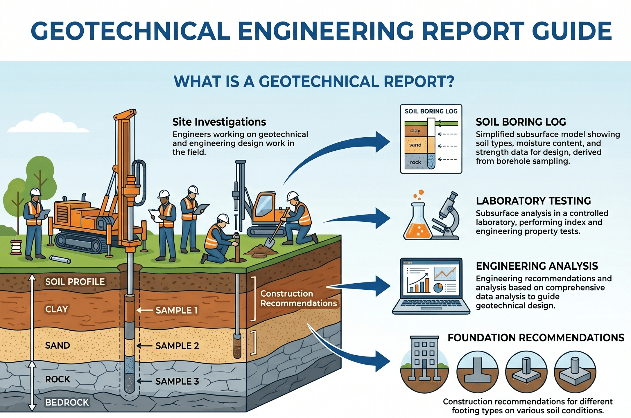
Notice that the report is not just raw data. The valuable part is the interpretation layer between borings and decisions. That is where soil observations become footing recommendations, fill requirements, drainage guidance, and project risk controls.
What is a geotechnical report?
A geotechnical report is the formal engineering document that explains what was found below the ground surface and what those findings mean for design and construction. On most projects, it combines exploration records, laboratory test results, groundwater observations, interpreted subsurface conditions, design parameters, construction recommendations, and limitations of the study.
That distinction matters. A boring log by itself is data. A geotechnical report is interpretation. It answers practical questions such as: Are shallow foundations feasible? Is differential settlement likely? Does the site contain compressible, expansive, collapsible, loose, or uncontrolled fill materials? Are there groundwater conditions that change excavation support, dewatering, pavement design, or long-term performance?
In real practice, the report often becomes the ground “source of truth” for the design team. Structural engineers use it for bearing pressures and lateral earth assumptions. Civil engineers use it for earthwork and pavement inputs. Contractors use it to anticipate excavation conditions, groundwater issues, rock refusal, and working platform needs. Owners use it to understand risk, budget exposure, and whether more exploration is justified.
The value of a geotechnical report is not the number of pages. It is whether the report converts uncertain ground conditions into clear, testable, project-specific decisions.
What a geotechnical report usually includes
Most geotechnical reports follow a recognizable logic. They begin with project understanding, then move into field exploration, laboratory testing, interpretation, and recommendations. The exact structure varies by project size and region, but strong reports usually cover the same core elements.
Core sections you should expect to see
A complete report typically includes project description, scope of investigation, site and geologic setting, field exploration methods, boring and test pit logs, groundwater observations, laboratory testing, interpreted subsurface profile, analysis assumptions, recommendations, and limitations. Some reports also include seismic site class, liquefaction screening, pavement sections, retaining wall inputs, or slope-related discussion.
- qallow Allowable bearing pressure, usually reported in ksf, psf, kPa, or MPa depending on region and project type.
- S Estimated settlement or movement criteria, often the real serviceability driver even when bearing appears adequate.
- γ Soil unit weight used in earth pressure, overburden, and slope or retaining calculations.
- ϕ Friction angle for granular or drained strength analysis; must match the soil type and drainage assumptions.
- c or cu Cohesion or undrained shear strength, often important in clay behavior and temporary stability discussions.
- k Hydraulic conductivity or permeability indicator, relevant when drainage, seepage, or dewatering matters.
Never pull one parameter out of a report in isolation. Read the assumptions, the applicable foundation type, the groundwater discussion, and any notes about settlement, frost, fill, or construction sequence before using the number.
Why the boring logs are not enough by themselves
Boring logs are essential, but they show point data at specific locations and depths. They do not automatically define the entire site. The geotechnical engineer has to decide which strata are continuous, where variability is likely, whether fill quality is reliable, and whether lab results align with field observations. That interpretive step is what turns exploration into engineering guidance.
How engineers read a geotechnical report in practice
Engineers rarely read a geotechnical report straight through once and move on. They scan it with a purpose. A structural engineer looks for foundation recommendations and lateral loads. A site civil engineer looks for earthwork, subgrade, and drainage guidance. A reviewer looks for whether the recommendations actually follow from the data.
Step 1: Confirm the project description matches the actual project. If the building size, loads, grades, retaining geometry, or pavement intent changed, the report may no longer fit.
Step 2: Read the subsurface summary before diving into individual logs. Identify fill, soft layers, rock depth, groundwater, and major variability.
Step 3: Find the recommendations section and mark the items that control design: foundation type, bearing limits, settlement expectations, slab support, lateral earth pressures, earthwork criteria, and drainage requirements.
Step 4: Cross-check those recommendations against the logs, lab data, and limitations. Ask whether the assumptions are project-wide or only valid in certain areas.
Step 5: Identify open risks: undocumented fill, wet weather behavior, seasonal groundwater, collapsible zones, excavation instability, or the need for proof-rolling and undercut decisions during construction.
The strongest reading habit is to ask, “What recommendation here could change a drawing, a detail, a specification, or a contractor’s means and methods?” Those are the lines that matter most.
Parameters, interpretations, and calculations behind the report
Many geotechnical reports do not show every calculation in full detail, but the recommendations usually come from familiar geotechnical checks: bearing capacity, settlement, lateral earth pressure, slope stability, seepage, compaction targets, or pavement support. The report often presents the usable outcome rather than the full derivation.
One common example is allowable bearing pressure. The geotechnical engineer may estimate an ultimate or nominal capacity, then reduce it using a factor of safety and serviceability limits such as tolerable settlement. In practice, the recommended value is often controlled more by movement than by pure shear failure.
For compressible layers, the report may also connect vertical strain to estimated settlement, where \( \Delta H \) is settlement, \( H \) is layer thickness, and \( \varepsilon \) is strain under loading. Whether the analysis uses elastic, consolidation, empirical, or strain-based methods depends on soil type, project stage, and available testing.
If a report gives a generous bearing value but says little about differential settlement, fill variability, or groundwater, the number may be less useful than it looks. Settlement often governs before shear capacity does.
Common parameter groups in reports
Design parameters are usually grouped by use case rather than by textbook chapter. A report may separate values for shallow foundations, temporary excavations, pavements, slabs-on-grade, retaining walls, drilled piers, driven piles, or seismic design. That is a clue that the same site material may not justify one universal number for every calculation.
Worked example: pulling the real design inputs from a report
Example
Imagine a one-story light industrial building with shallow spread footings and a slab-on-grade. The geotechnical report states that near-surface soils include 2 to 4 feet of fill over medium stiff clay and dense sandy clay. Groundwater was not encountered during drilling, but the report notes that perched water may appear seasonally after heavy rainfall.
In the recommendations, the report permits conventional shallow foundations bearing at least 18 inches into undisturbed competent natural soil or properly recompacted engineered fill. It recommends an allowable bearing pressure of 2,500 psf for dead-plus-live loading, estimates total settlement of about 1 inch with smaller differential movement if bearing levels are consistent, and requires proof-rolling with undercut and replacement of soft zones encountered at subgrade.
A rushed reader might only copy the 2,500 psf value into the footing schedule. A better reader extracts the full design meaning:
- The footing value is conditional on bearing in competent material, not in uncontrolled fill.
- The slab and footing performance depend on subgrade preparation and proof-rolling, not just design calculations.
- Seasonal water could affect excavation stability and moisture-sensitive clay behavior even though borings were dry.
- Settlement is acceptable only if footing elevations and support conditions are reasonably consistent across the building.
That is why geotechnical reporting is not just about numbers. It is about conditional recommendations. The “if” statements are often more important than the parameter itself.
Engineering judgment and field reality
The field almost never matches the report perfectly. Exploration samples only a limited part of the site, weather shifts moisture conditions, grading changes stress paths, and contractors expose conditions the borings did not capture exactly. Good geotechnical reporting anticipates that and tells the project what to verify during construction.
One of the most common disconnects is between “recommended founding material” in the report and what is actually exposed at footing level. Another is between drilling-time groundwater observations and wet-season reality. Reports often include notes that groundwater can fluctuate, but teams sometimes treat one dry boring log as permanent truth. That is a mistake.
A second field reality is that earthwork quality can dominate performance. A site may have acceptable native material at depth, but if stripping, moisture conditioning, recompaction, and proof-rolling are not enforced well, slab and pavement performance can still suffer. The report should be read together with the specifications and special inspection expectations, not as a standalone comfort document.
The most dangerous misuse of a geotechnical report is treating it as permission to stop observing the ground. The report should guide field verification, not replace it.
When this breaks down
A geotechnical report becomes less dependable when the project changes substantially after the study or when the site is more variable than the exploration density can reasonably capture. Building relocations, deeper cuts, heavier loads, new retaining walls, basement additions, different pavement sections, or revised grading can invalidate earlier recommendations.
The method also breaks down when readers assume that all recommendations apply everywhere on the site with equal confidence. Sites with uncontrolled fill, karst features, soft pockets, organics, expansive clay, buried debris, shallow rock, or variable groundwater need more caution. In those conditions, a report should be read as a model with uncertainty, not as perfect certainty.
Another breakdown point is poor parameter transfer. A value appropriate for temporary excavation support may not be suitable for permanent retaining design. A bearing value given for lightly loaded spread footings may not justify a mat foundation without separate settlement evaluation. Even within one report, parameter context matters.
Common pitfalls and engineering checks
- Using one parameter from the executive summary without reading the assumptions and limitations.
- Ignoring whether the recommendation applies only after undercut, recompaction, moisture conditioning, or engineered fill placement.
- Confusing “no groundwater encountered” with “groundwater is impossible.”
- Failing to coordinate footing depths, slab support, retaining systems, and site grading with the same geotechnical assumptions.
- Assuming the report automatically reflects revised architecture or changed structural loads.
- Ignoring seismic, frost, swell, or drainage notes because they are not in the primary foundation table.
One of the costliest mistakes is designing to the report but building to field conditions that were never verified. A recommendation tied to “competent native soil” is not satisfied unless the field actually confirms competent native soil.
| Report item | Why it matters | Typical units | Engineering check |
|---|---|---|---|
| Allowable bearing pressure | Controls footing sizing and contact stress assumptions | psf, ksf, kPa | Confirm founding material, embedment, and settlement conditions match the recommendation |
| Estimated settlement | Controls serviceability and differential movement risk | in, mm | Check total and differential movement, not just capacity |
| Lateral earth pressure | Controls retaining and below-grade wall design | pcf equivalent, kN/m³ equivalent, pressure diagrams | Verify at-rest, active, passive, surcharge, drainage, and seismic assumptions |
| Earthwork criteria | Controls subgrade performance and long-term movement | % compaction, moisture range | Coordinate with specifications, testing frequency, and observation requirements |
| Groundwater observations | Controls excavation, drainage, seepage, and durability issues | Depth below grade | Account for seasonal and weather-related variability |
How to think about a geotechnical report visually
The easiest way to understand a geotechnical report is to picture it as a chain with four links: observe, interpret, recommend, and verify. The borings and lab tests are the observation link. The subsurface model is the interpretation link. The design tables and construction notes are the recommendation link. Site observation, proof-rolling, testing, and field adjustment are the verification link.
Weak reports usually break that chain. They may have data but poor interpretation, or recommendations without clear field verification language. Strong reports make each link visible so the design team understands not only the conclusions, but also how much confidence to place in them.
Relevant standards and design references
The exact references depend on project type, but geotechnical reports commonly rely on field and laboratory standards, building code requirements, and agency-specific manuals. These references define how data are obtained and how recommendations are framed.
- ASTM D1586: Standard Penetration Test. Commonly used to characterize subsurface stratigraphy and relative density/consistency in boring programs.
- ASTM D2487 and ASTM D2488: Unified Soil Classification System and field identification procedures. These support consistent classification language in logs and report summaries.
- ASTM D698 / ASTM D1557: Standard and Modified Proctor compaction methods. These are often the basis for earthwork moisture-density criteria in report recommendations.
- IBC and ASCE 7, where applicable: Used when the report addresses foundation support assumptions, seismic site class, and geotechnical coordination with building design.
- Project-specific DOT, municipal, or owner standards: These often control pavement support, utility trench backfill, retaining wall loads, and acceptance criteria in ways the general report must coordinate with.
Frequently asked questions
In everyday project language, the terms are often used interchangeably, but a geotechnical report is usually broader. It does not just describe soil; it interprets subsurface conditions and gives recommendations for foundation design, earthwork, drainage, and construction risk.
Some simple projects may use prescriptive code rules, but most engineered foundation design should rely on geotechnical recommendations when soil variability, settlement, groundwater, or site-specific loading matters. Without that input, the design team may be guessing at the conditions that control real performance.
The most important part is usually the interpreted subsurface model connected to clear recommendations. Raw logs and lab data matter, but the real value is the engineering judgment that turns those observations into usable design and construction guidance.
A report should be revisited whenever project loads, grades, foundation types, retaining geometry, or site layout change materially, or when field conditions differ from the investigation assumptions. It should also be revisited if the report is old enough that site use, groundwater, fill history, or governing criteria may no longer match current conditions.
Summary and next steps
A geotechnical report is the engineering bridge between subsurface data and project decisions. Its real purpose is not to archive soil information, but to help the team choose foundations, define earthwork requirements, understand drainage and groundwater issues, and manage the uncertainties that can affect cost, schedule, and performance.
The strongest reports are project-specific, conditional, and honest about uncertainty. They explain what was found, what it means, what assumptions matter, and what has to be verified in the field. When you read one, focus less on isolated numbers and more on the logic connecting site conditions to recommendations.
In practice, the best use of a geotechnical report is as a living coordination tool between geotechnical engineering, structural design, site civil work, specifications, and construction observation. That is where the report becomes valuable enough to prevent redesign, poor assumptions, and expensive surprises.
Where to go next
Continue your learning path with these curated next steps.
-
Read a deeper dive on Geotechnical Data Analysis
See how field and laboratory data are cleaned, interpreted, and converted into defensible design parameters.
-
Study Geotechnical Risk Assessment
Useful when the next step is ranking uncertainty, consequence, and mitigation decisions rather than just collecting more data.
-
Review What Is Geotechnical Engineering?
A broader foundation page that connects geotechnical reports to investigation, soil behavior, groundwater, and design workflows.