Key Takeaways
- Core idea: Flood warning systems convert rainfall, stream stage, forecast, and watershed data into warnings that support timely protective action.
- Engineering use: They are used for river corridors, urban drainage systems, low-water crossings, dams, emergency operations, and flood-prone communities.
- What controls it: Warning reliability depends on watershed response time, gauge placement, telemetry, thresholds, forecast uncertainty, and response protocols.
- Practical check: A warning system is only effective if the alert is connected to a clear action such as closing a road, notifying officials, or issuing an evacuation message.
Table of Contents
Introduction
Flood warning systems are monitoring and communication networks that detect rising flood risk and help communities act before conditions become dangerous. They combine rainfall measurements, stream gauges, telemetry, forecast data, flood thresholds, monitoring platforms, and alert channels so engineers and emergency managers can move from raw water data to timely public warnings.
How Flood Warning Systems Work
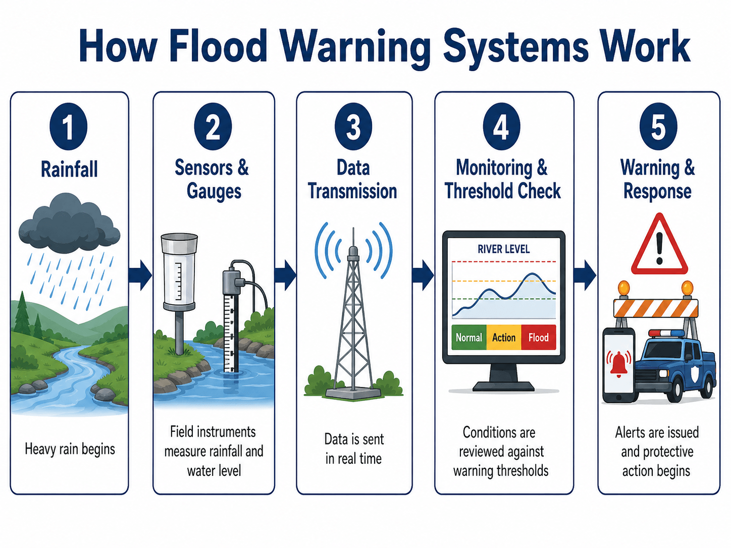
The most important idea is that the warning is not created by a single sensor. It depends on a connected system of field data, communication, interpretation, and response.
What Is a Flood Warning System?
A flood warning system is a coordinated setup used to detect, evaluate, and communicate flood risk. In water resources engineering, it usually includes field sensors, stream or river gauges, rainfall data, telemetry, forecast information, flood thresholds, monitoring software, and public or agency alert channels.
The purpose is not simply to measure water. The system must turn measurements into a decision: whether a creek, river, drainage corridor, road crossing, floodplain, or community is approaching a condition where action is needed. That action may be internal monitoring, a road closure, emergency staffing, public notification, or evacuation support.
Flood Warning System vs. Flood Early Warning System
A flood early warning system, often shortened to FEWS, emphasizes the full warning chain before impacts occur: risk knowledge, monitoring, forecasting, warning communication, and response readiness. In practice, many communities use “flood warning system” and “flood early warning system” to describe the same connected monitoring and alert process.
The strongest flood warning systems are designed backward from the required action. Engineers first ask what decision must be made, how much lead time is needed, and what water level or rainfall condition should trigger that decision.
Main Components of a Flood Warning System
Flood warning systems combine physical instruments, data transmission, interpretation tools, and communication pathways. A stream gauge without a warning threshold is only a monitoring point. A threshold without a reliable alert channel is only an internal data flag. The system becomes useful when each component supports the next step.
Common flood warning system equipment includes rain gauges, stream gauges, pressure transducers, radar rainfall inputs, solar panels, batteries, telemetry radios, cellular modems, satellite communication, field cameras, monitoring dashboards, sirens, road closure devices, and public alert software.
| Component | What it does | Why it matters for warnings |
|---|---|---|
| Rain gauges and radar rainfall | Measure precipitation depth, intensity, and storm movement across the watershed. | Rainfall can provide early warning before the river or creek reaches flood stage. |
| Stream gauges and stage sensors | Measure water level, often called stage, at rivers, channels, bridges, or low-water crossings. | Stage is often tied directly to impacts such as bank overtopping, road flooding, or property risk. |
| Telemetry and power systems | Transmit field measurements by radio, cellular, satellite, or wired networks, often with solar or battery backup. | Warnings depend on data arriving during severe weather, when power and communications may be stressed. |
| Monitoring platform | Displays maps, gauges, hydrographs, threshold status, forecast data, and alerts. | Helps engineers and emergency managers see whether conditions are normal, rising, or dangerous. |
| Threshold logic | Compares water level, rainfall, rate of rise, or forecasts to predefined trigger points. | Turns raw data into a warning decision or escalation step. |
| Alert and response channels | Send warnings through dashboards, texts, sirens, agency notifications, public alerts, or field crews. | Connects the warning to protective action. |
Types of Flood Warning Systems
Not every flood warning system is designed for the same hazard. A large river system, an urban underpass, a low-water crossing, and a steep flash-flood basin may all require different monitoring points, thresholds, communication paths, and response actions.
| System type | Best used for | Typical data used | Main limitation |
|---|---|---|---|
| River flood warning system | Larger rivers, floodplains, and downstream communities. | River stage, streamflow, forecast crests, upstream gauges, and precipitation. | May not capture highly localized flash flooding away from the monitored channel. |
| Flash flood warning system | Small, steep, urbanized, or fast-response watersheds. | Rainfall intensity, radar rainfall, rate of rise, and short-interval gauge data. | Lead time may be very short, so thresholds and alerts must be fast and reliable. |
| Low-water crossing warning system | Road crossings, dips, culverts, and flood-prone transportation routes. | Stage sensors, road overtopping elevation, local rainfall, and field confirmation. | Must connect directly to barricades, road closure messages, or driver warnings. |
| Urban drainage warning system | Underpasses, storm drains, pump stations, detention outlets, and dense urban areas. | Rainfall, water level, pump status, inlet capacity, and local drainage behavior. | Impacts can be highly local and may change quickly during intense storms. |
| Dam or reservoir warning support | Reservoir operations, downstream flood routing, and emergency action planning. | Reservoir pool elevation, releases, inflow, rainfall forecast, and downstream stage. | Requires strong operating procedures and coordination with emergency action plans. |
Flood Warning Thresholds and Linked Actions
A flood warning threshold is a trigger value that connects measured or forecast conditions to a response. Thresholds may be based on river stage, rainfall depth, rainfall intensity, streamflow, rate of rise, known road overtopping elevations, critical infrastructure elevations, or modeled flood impacts.
The diagram below shows the practical idea: each rising water level should correspond to a clearly defined response level. This is where flood monitoring connects directly to flood risk assessment, because the warning threshold should reflect what is actually exposed at that stage.
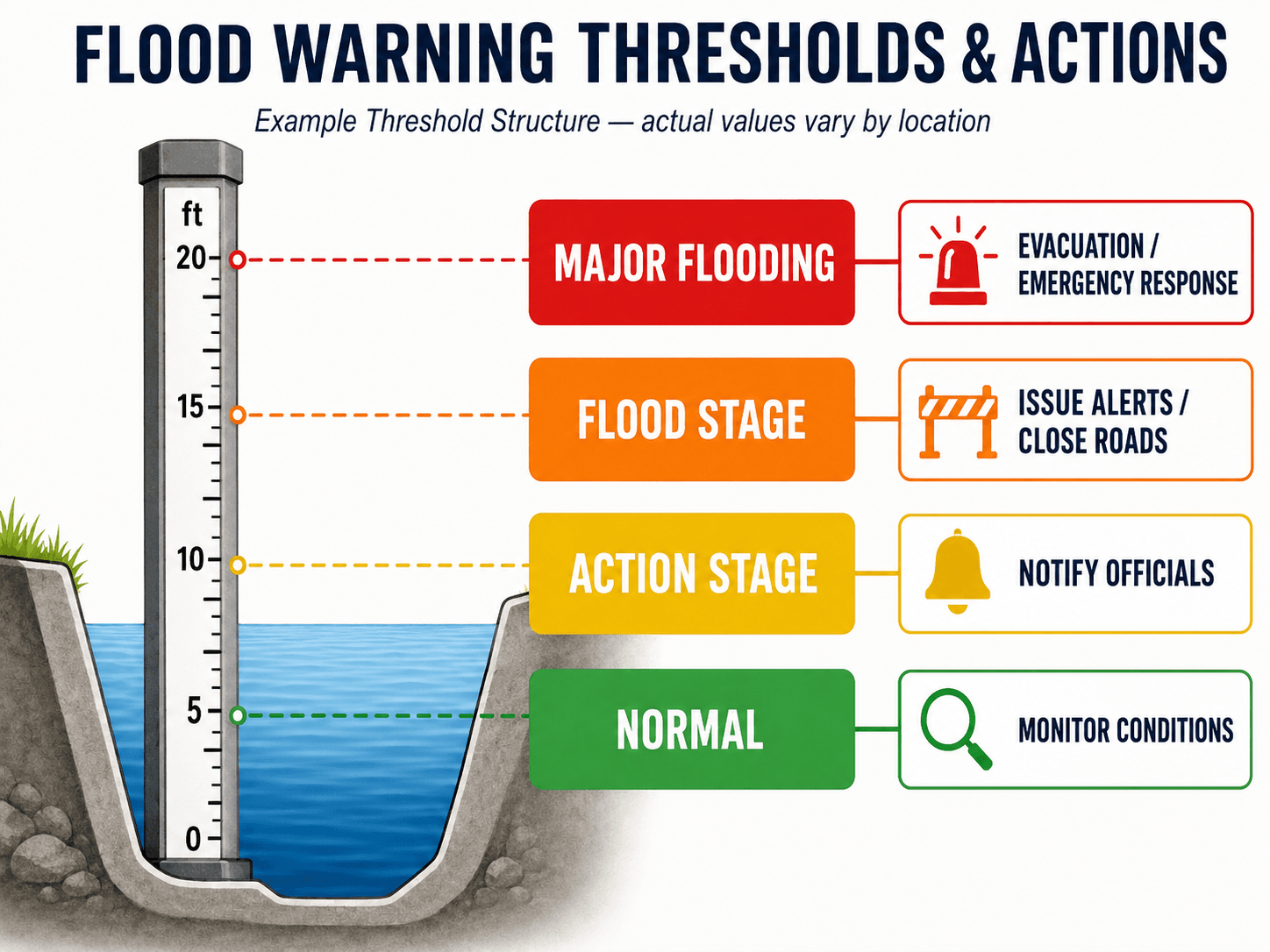
The threshold should reflect what happens at the site, not just an arbitrary number on a gauge. For example, one stage may indicate that crews should monitor a low-water crossing, while a higher stage may trigger road closure, public alerts, or emergency response.
In stronger systems, gauge thresholds are connected to flood inundation maps or impact libraries. Instead of only saying that a river is at a certain stage, the system can help estimate which roads, neighborhoods, structures, emergency access routes, or utilities may be affected at that level.
| Threshold type | What it means | Typical engineering use |
|---|---|---|
| Monitoring threshold | Conditions are rising but still below the level where flooding is expected. | Increase observation frequency, check gauges, and verify forecast trends. |
| Action stage | Water levels are high enough that preparation or agency notification may be needed. | Notify public works, stage barricades, check pump stations, and prepare field response. |
| Flood stage | Flooding is expected, imminent, or occurring at known impact locations. | Issue warnings, close impacted roads, activate emergency operations, or notify the public. |
| Major flood threshold | Flooding may threaten life, property, infrastructure, or emergency access. | Escalate to emergency response, evacuation support, shelter planning, and interagency coordination. |
Why Flood Warning Lead Time Varies
Warning lead time is the time between detecting a dangerous condition and when flooding affects the area of concern. It is one of the most important performance measures for a flood warning system because a warning that arrives too late may not support meaningful action.
In hydrology, lead time is strongly influenced by how quickly rainfall becomes runoff and how quickly that runoff moves through the watershed. The visual below compares a small, steep watershed with a larger river basin.
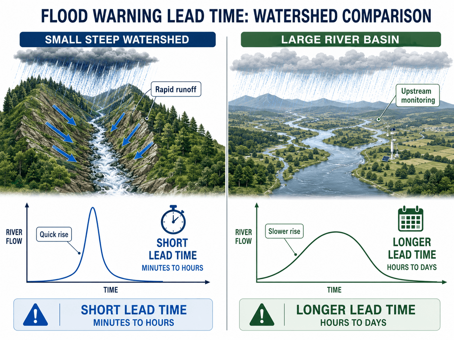
A steep urban creek may rise quickly because rainfall becomes runoff with little storage or travel time. A larger river basin may provide more lead time because upstream gauges and forecasts show the flood wave moving downstream. However, lead time is never guaranteed; it depends on storm speed, rainfall intensity, soil saturation, watershed slope, channel storage, and the location of the monitoring points.
The same amount of rainfall can produce very different warning times in two watersheds. A short, steep basin with saturated soil may provide only limited reaction time, while a larger monitored river corridor may provide enough time for staged response.
From Flood Data to Public Warning
Flood warning systems are most useful when the data path is simple, tested, and connected to a real decision. A strong system does not stop at collecting measurements; it converts those measurements into a warning that reaches the right people in time.
- Observe: Rainfall, stream stage, radar rainfall, forecast data, and field observations are collected.
- Validate: Data is checked for missing readings, sensor errors, unrealistic jumps, or communication gaps.
- Interpret: Conditions are compared against thresholds, forecast crests, rate-of-rise triggers, and known impact elevations.
- Escalate: Alerts are routed to emergency managers, public works staff, dispatch, road crews, or automated warning systems.
- Act: Roads are closed, crews are dispatched, sirens or public alerts are issued, or evacuation support begins.
If a flood warning dashboard shows a threshold exceedance but no one knows who receives the alert or what action follows, the system is not operationally complete.
Flood Watch, Advisory, Warning, and Emergency
Flood warning systems often support public alert products, but the monitoring system and the alert term are not the same thing. The system collects and interprets data. The alert communicates the level of risk and what people or agencies should do.
| Alert term | General meaning | How a flood warning system supports it |
|---|---|---|
| Flood watch | Flooding is possible based on forecast conditions. | Forecast rainfall, saturated soils, and basin conditions are monitored for escalation. |
| Flood advisory | Minor flooding or nuisance flooding may create hazardous travel or localized impacts. | Rainfall and local drainage indicators may show ponding, poor drainage, or rising small streams. |
| Flood warning | Flooding is expected, imminent, or already occurring. | Observed or forecast levels exceed a threshold tied to known impacts. |
| Flash flood warning | Rapid flooding is expected or occurring, often with limited lead time. | Rainfall intensity, radar estimates, small-basin response, and rapid stage rise are watched closely. |
| Flood emergency | Severe flooding creates an immediate threat to life or major infrastructure. | Monitoring data supports urgent warnings, emergency operations, closures, and rescue coordination. |
Automated Alerts, Human Review, and Warning Communication
Some flood warning systems automatically send notifications when a threshold is crossed, while others flag conditions for review by emergency managers, public works staff, or forecasters. Automated alerts are fast, but they require carefully calibrated thresholds and reliable sensors. Human-reviewed warnings can account for field context, but they may take longer to issue.
The best approach often combines both. Automated notifications can alert staff immediately, while trained personnel confirm conditions, evaluate field impacts, coordinate with agencies, and decide whether to escalate to public-facing warnings.
Common Flood Warning Communication Channels
- Monitoring dashboards: Useful for engineers, emergency managers, and operations centers, but not enough by themselves for public warning.
- SMS, email, and app notifications: Fast for agency staff and subscribers, but dependent on network availability and current contact lists.
- Sirens and outdoor alerting: Useful near high-risk areas, but limited because they provide little detail and may not be heard indoors.
- Road closure signs and barricades: Highly effective for low-water crossings when the warning is tied directly to site-specific action.
- Public information channels: Websites, social media, and local alerts can reinforce the warning but should not be the only response path.
Engineering Design Considerations for Flood Warning Systems
Flood warning system design starts with the question: what location needs protection, and how much time is required to act? The answer controls gauge placement, data frequency, communication redundancy, trigger levels, alert pathways, and maintenance expectations.
- Gauge location: Upstream gauges can increase lead time, but they must represent the contributing watershed and critical risk location.
- Data frequency: Fast-response basins may need more frequent reporting than slow-rising rivers.
- Threshold calibration: Trigger levels should be tied to actual impacts such as road overtopping, structure flooding, or emergency access loss.
- Redundancy: Power, telemetry, and sensor backup matter because flood systems are needed most during severe weather.
- Communication path: Alerts should reach the correct people through reliable channels before the critical action time has passed.
- Operations plan: A warning should identify who receives it, who verifies it, who acts, and what response is expected.
If a warning threshold is reached, the system should already know the next action. Ambiguous alerts create delays, especially when multiple agencies share responsibility for roads, drainage infrastructure, and public communication.
Example: Warning Workflow for a Low-Water Crossing
Low-water crossings are a practical example because the warning target is specific: keep vehicles and pedestrians out of a flooded roadway. The system may use a nearby stream gauge, rainfall intensity, and a road overtopping threshold to determine when response steps should begin.
Typical Warning Sequence
- Rainfall begins: Local rain gauges or radar rainfall indicate that the drainage area is receiving intense rainfall.
- Water level rises: A stage sensor near the crossing shows the creek approaching the action threshold.
- Staff are notified: Public works or emergency management receives an internal alert to check conditions and prepare response.
- Road closure threshold is reached: The gauge reaches the level associated with unsafe roadway flooding.
- Protective action begins: Barricades, road closure messages, warning signs, dispatch notices, or public alerts are activated.
This example shows why the threshold should be based on the actual roadway hazard, not just the height of water in the channel. A useful warning system connects the stage reading to a decision that protects people before the crossing becomes unsafe.
Senior Engineer Review Checklist
A flood warning system should be reviewed as an operational system, not just an instrumentation project. The checklist below helps evaluate whether the monitoring network, thresholds, communications, and response actions are aligned.
Identify the protected location, estimate the needed response time, select upstream or local monitoring points, define impact-based thresholds, test communication paths, assign response actions, and maintain the system before storm season.
| Review item | What to look for | Why it matters |
|---|---|---|
| Critical location | Road crossing, neighborhood, pump station, bridge, levee segment, dam outlet, or floodplain area requiring action. | The system must warn for a specific consequence, not just a high water reading. |
| Watershed response time | Steep slopes, urban impervious area, small drainage area, saturated soils, or limited storage. | Fast response reduces the time available for warning and field action. |
| Gauge placement | Monitoring points upstream of the risk location with enough travel time to support response. | Poor gauge placement may detect flooding after it has already reached the problem area. |
| Threshold basis | Trigger levels tied to road overtopping, bankfull stage, structure flooding, mapped inundation, or emergency access loss. | Impact-based thresholds are more useful than arbitrary gauge levels. |
| Telemetry reliability | Backup power, redundant communication, equipment elevation, and storm-resistant installation. | Flood systems must keep working when weather, debris, and outages are most likely. |
| Alert recipients | Public works, emergency management, road crews, operations center, dispatch, and public notification channels. | The right warning must reach the right decision-maker quickly. |
| Maintenance plan | Sensor calibration, debris checks, battery replacement, communication tests, and threshold review. | A neglected system can create false confidence before a major flood event. |
Engineering Judgment and Field Reality
Flood warning systems must deal with uncertainty. Rainfall may shift away from the forecast track, debris may block a culvert, a gauge may be damaged, or a storm may intensify over a small subwatershed. Experienced engineers review both the data and the physical setting because a dashboard does not automatically understand every field condition.
Local knowledge is especially important at low-water crossings, undersized culverts, bridges with debris risk, rapidly urbanizing watersheds, and areas where previous floods created known trouble spots. A warning threshold that worked before development may become unreliable after land use changes increase runoff speed and peak discharge. This is one reason flood warning systems should be coordinated with floodplain management and long-term flood planning.
A flood warning system can show that water is rising, but engineers still need to ask why it is rising, where the flood wave is moving, what infrastructure is exposed, and whether the response plan can act before the hazard reaches people.
When Flood Warning Systems Break Down
Flood warning systems are vulnerable when the monitoring network, thresholds, communication pathways, and emergency actions are not maintained as one system. A sensor can be accurate and still fail the community if the warning arrives too late or the response action is unclear.
- Sensor or telemetry failure: Damaged gauges, dead batteries, radio interference, cellular outages, or flooded equipment can interrupt data when it is needed most.
- Poor threshold calibration: If trigger levels do not match real flood impacts, warnings may be late, excessive, or ignored.
- Insufficient lead time: Small, steep, urban watersheds may respond faster than the warning and response process.
- False alarm fatigue: Frequent alerts that do not match visible impacts can reduce trust in future warnings.
- Unclear ownership: If no agency or person is responsible for verifying the warning and acting, the system may stall at the decision point.
Maintenance is especially important before storm season. Field crews may need to clean debris from gauge locations, verify sensor calibration, test batteries, confirm telemetry, inspect solar panels, and make sure alert recipients are still current.
Common Mistakes and Practical Checks
The most common mistake is treating flood warning as a technology problem only. The technical network matters, but the system succeeds when monitoring, interpretation, communication, and action are designed together.
- Using gauge levels without impact mapping: A number on a gauge should be tied to known consequences such as road closure elevation or property exposure.
- Ignoring upstream travel time: Gauges placed too close to the risk location may detect the flood but not provide useful warning time.
- Relying on one communication path: A single cellular modem, power source, or dashboard can become a weak point during severe weather.
- Not testing the response chain: Alerts should be tested before storms so agencies know who receives, confirms, and acts on each warning.
- Letting thresholds become outdated: Channel changes, new development, culvert blockage, or revised flood mapping can change what a gauge level means.
Do not assume that a real-time gauge automatically creates a useful warning. A flood warning system needs a calibrated threshold, reliable communication, and a response plan that can act within the available lead time.
Data Sources and Design References
Flood warning systems often use a combination of local monitoring, agency forecasts, watershed models, field observations, and public data tools. For technical context, USGS flood resources are useful because they connect streamflow, precipitation, rate-of-change, flood stage, and real-time monitoring data—the same types of observations that engineers and emergency managers use when evaluating flood warning conditions.
- USGS Flood Information: USGS real-time flood data and National Water Dashboard resources provide access to streamflow, precipitation, rate-of-change, flood stage, and related flood monitoring resources that support flood response and interpretation.
- Project-specific criteria: Local flood studies, emergency action plans, drainage manuals, road closure procedures, and agency alert protocols may control how thresholds and response actions are set.
- Engineering use: Engineers use observed data, forecast information, site impacts, and local response requirements to review whether a warning threshold is meaningful and actionable.
Frequently Asked Questions
A flood warning system is a coordinated monitoring and communication system that tracks rainfall, water levels, forecasts, and flood thresholds so warnings can be issued before or during dangerous flood conditions.
Flood warning systems collect rainfall and river-level data, transmit it to a monitoring platform, compare current and forecast conditions against warning thresholds, and trigger alerts or emergency actions when flood risk becomes high.
A flood watch means flooding is possible and conditions should be monitored closely, while a flood warning means flooding is expected, imminent, or already occurring and protective action may be needed.
Lead time depends on watershed size, slope, soil saturation, rainfall intensity, impervious cover, gauge placement, forecast quality, and how quickly data is converted into an alert or response decision.
Yes. Flood warning systems can fail when sensors are damaged, telemetry is lost, thresholds are poorly calibrated, gauges are placed too far downstream, maintenance is neglected, or warnings are not tied to clear emergency actions.
Summary and Next Steps
Flood warning systems help communities move from monitoring to action. They combine rainfall data, stream gauges, telemetry, thresholds, forecasts, dashboards, and alert channels so rising flood risk can be identified and communicated before impacts become severe.
The practical value of a warning system depends on lead time, gauge placement, threshold calibration, communication reliability, maintenance, and the response plan attached to each alert. A technically sound system must be designed around the specific watershed and the specific decisions that need to be made.
Where to go next
Continue your learning path with related Turn2Engineering resources.
-
Flood Risk Assessment
Learn how exposure, probability, vulnerability, and consequences are evaluated before selecting warning or mitigation strategies.
-
Flood Predictive Modeling
Explore how rainfall, terrain, hydrologic data, and forecast tools support flood prediction and warning decisions.
-
Floodplain Management
See how land-use planning, maps, development rules, and risk reduction strategies work with warning systems.