Key Takeaways
- Definition: Geotechnical software includes digital tools used to analyze soil, rock, groundwater, and soil-structure interaction for design, assessment, and construction decisions.
- Use case: Engineers use it to screen alternatives, model failure mechanisms, estimate movement, assess stability, and organize defensible calculations and reports.
- Main decision: The key judgment is choosing the simplest tool that can answer the real project question without hiding critical assumptions.
- Outcome: After reading, you should be able to sort software by purpose, know what inputs control credibility, and recognize when a model is no longer trustworthy.
Table of Contents
Introduction
In brief: Geotechnical software is the set of digital tools engineers use to model ground behavior, test scenarios, organize calculations, and support safer geotechnical decisions.
Who it’s for: Students, FE/PE prep, and practicing designers.
For informational purposes only. See Terms and Conditions.
Good software can speed up geotechnical work dramatically, but only when the method, inputs, and interpretation match the actual ground conditions and project risk.
Geotechnical Software infographic
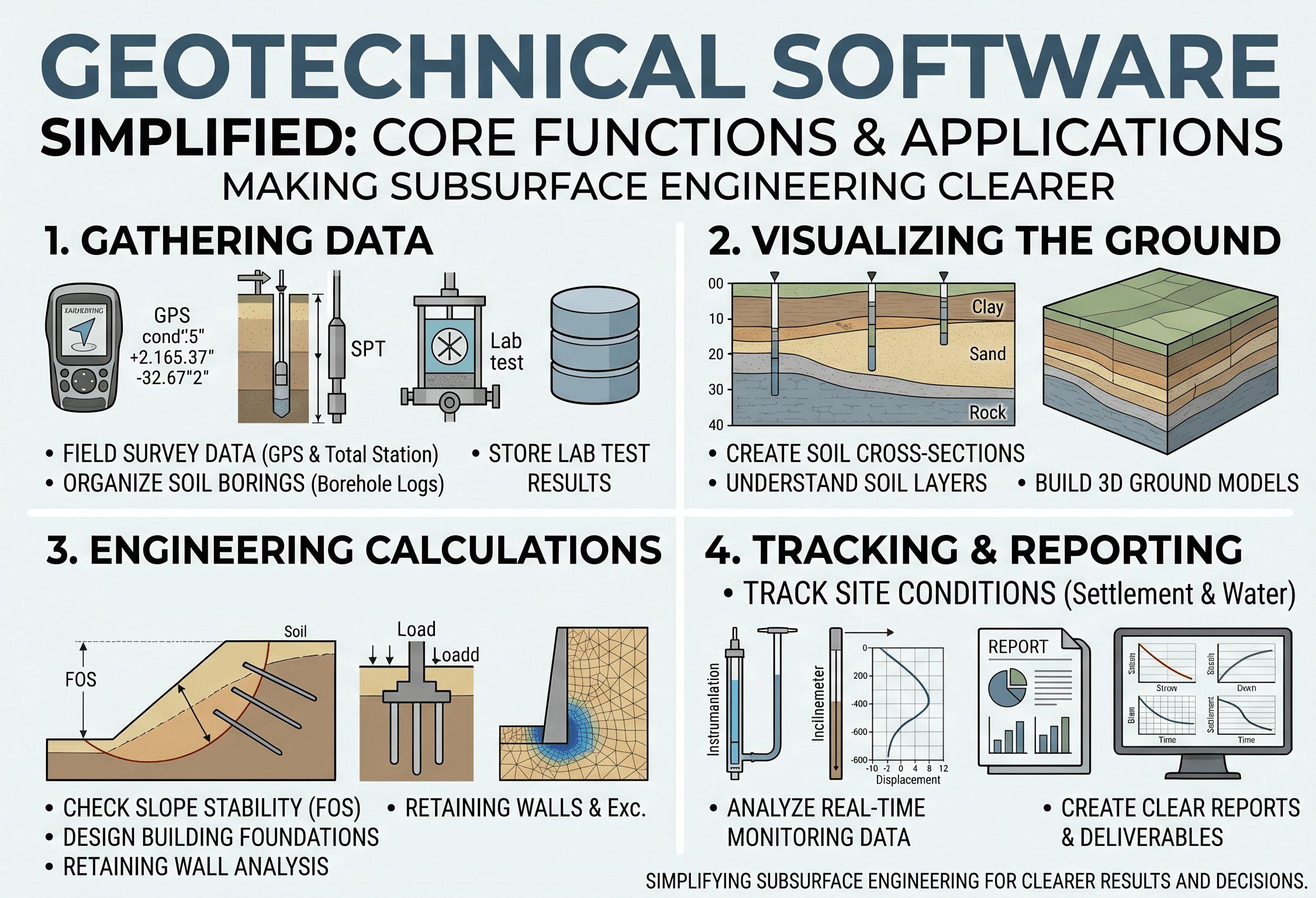
Notice that the software is only one part of the chain. The strongest models begin with reliable site characterization, realistic groundwater assumptions, and parameters that can be justified from testing and engineering judgment.
What is geotechnical software?
Geotechnical software is a broad category of digital tools used to analyze, design, visualize, and document how soil, rock, and groundwater will behave under loading, excavation, seepage, seismic shaking, or staged construction. The category includes everything from spreadsheet-based bearing checks and retaining wall routines to advanced finite element and finite difference platforms that simulate stress redistribution, deformation, pore pressure change, and soil-structure interaction.
In practice, geotechnical software is not valuable because it looks sophisticated. It is valuable because it helps an engineer answer a specific project question more clearly. That question might be, “Is the slope stable enough under rapid drawdown?” “Will a shallow footing settle too much?” “Does an excavation need another support level?” or “How sensitive is liquefaction triggering to the groundwater table?”
The important shift is this: software is not the design. Software is the environment where assumptions are assembled, calculations are organized, and results are tested. A good geotechnical engineer still has to define the failure mode, choose the correct analysis level, and judge whether the output makes physical sense. If you need a stronger foundation in the behavior behind those inputs, start with Soil Mechanics and What is Geotechnical Engineering.
Core principles, variables, and units
No matter which program you use, most geotechnical software platforms are solving some combination of equilibrium, compatibility, stress-strain behavior, flow, or time-dependent dissipation. The interface may look different from one package to another, but the underlying logic usually comes down to geometry, material behavior, boundary conditions, groundwater, loading, and construction sequence.
Key variables and typical ranges
The most critical variables are not always the ones buried deepest in the menu. On many projects, the model is controlled by a small set of assumptions: undrained shear strength, drained friction angle, stiffness, permeability, unit weight, groundwater elevation, and the sequencing of excavation or fill placement. A slightly unconservative value in one of those areas can matter more than an entire page of secondary settings.
- \( \gamma \) Total or effective unit weight of soil or fill; often entered in kN/m³ or pcf; influences self-weight, stress, buoyancy, and earth pressure.
- \( c’ \) Effective cohesion; typically kPa or psf; often modest in sands and more meaningful in some cemented or structured materials.
- \( \phi’ \) Effective friction angle in degrees; one of the most influential strength parameters in drained problems such as slopes, retaining systems, and bearing checks.
- \( s_u \) Undrained shear strength; usually kPa or psf; central to short-term clay behavior, excavation stability, and temporary loading conditions.
- \( E \) or \( E_s \) Young’s modulus or soil stiffness; typically kPa, MPa, or ksi; strongly affects movement predictions in settlement and deformation modeling.
- \( k \) Hydraulic conductivity; often m/s or ft/s; drives seepage, pore pressure dissipation, dewatering behavior, and consolidation timing.
- \( u \) Pore water pressure; typically kPa or psf; controls effective stress and can completely change stability and deformation results.
- \( V_s \) Shear wave velocity; m/s or ft/s; used in seismic site response, dynamic stiffness estimation, and liquefaction-related workflows.
If a model feels too sensitive, that is usually a sign to revisit the ground model, groundwater assumptions, and parameter derivation before adding more numerical complexity.
Units also deserve more attention than many users give them. Geotechnical work often mixes stress, force, pressure, unit weight, density, and time-dependent flow terms. A model can look polished and still be wrong if one layer is entered in pcf while another is in kN/m³, or if a stiffness value intended in MPa is interpreted as kPa. For deeper testing context, the pages on Geotechnical Soil Testing, Triaxial Test, and Permeability Test are natural supporting references.
Decision logic or design workflow
Choosing geotechnical software is really a problem-definition exercise. Before opening a program, ask what decision you are trying to support, what failure mode matters most, how uncertain the subsurface conditions are, and how expensive it would be to be wrong. Those answers usually determine whether you need a quick screening tool, a conventional deterministic model, or a more advanced coupled analysis.
Step 1: Define the controlling question: stability, movement, seepage, seismic response, bearing, settlement, or construction staging.
Step 2: Start with the simplest method that can answer it transparently: hand check, chart, spreadsheet, or limit-equilibrium routine.
Step 3: Escalate only when geometry, groundwater, nonlinear behavior, or project risk demand more realism.
Step 4: Build the ground model from site investigation and lab data, not from software defaults.
Step 5: Run sensitivity checks before trusting a single “best estimate” result.
Step 6: Compare the output with field expectations, precedent projects, and independent checks.
A useful way to think about selection is by analysis ladder. Closed-form checks and spreadsheets are excellent for fast screening and teaching assumptions. Limit-equilibrium tools are often the workhorses for slopes, retaining systems, and global stability questions. Elastic or nonlinear finite element and finite difference tools become more appropriate when you care about deformation compatibility, staged loading, coupled seepage, or stress-path-dependent behavior. GIS-linked tools and data platforms help with terrain, mapping, and asset-level organization. Reporting tools matter too, because a defensible model is only as valuable as the clarity of the assumptions, figures, and recommendations that leave the office.
Equations and calculations
Geotechnical software automates many calculations, but it should never distance the engineer from the governing mechanics. Even advanced models should still be anchored to simple checks. One of the most common conceptual benchmarks is factor of safety, which compares available resistance to the loading or driving action that is trying to cause failure.
In slope stability software, the resisting action is tied to shear strength along a potential failure surface and the driving action is tied to gravity, surcharge, seepage forces, and geometry. In a bearing context, the same general logic appears when comparing ultimate resistance to service load. In earthquake workflows, engineers often connect dynamic input to small-strain stiffness using expressions such as \(G_{\max} = \rho V_s^2\), then reduce that stiffness to match strain-dependent behavior. In seepage and consolidation tools, Darcy-type flow logic and drainage path concepts still sit behind the user interface, even when the program is solving much more complex spatial problems.
The practical lesson is that software results should remain traceable to familiar engineering relationships. If a model predicts a dramatic change in performance, an experienced reviewer will usually ask what physical quantity changed: strength, stiffness, pore pressure, load path, drainage, or staging. That is why equation awareness is still critical even on software-heavy projects.
Worked example
Example
Consider a temporary support-of-excavation system for a basement cut adjacent to an existing building. The project team needs to know whether one row of struts is enough, whether basal heave is a concern, and how much wall movement might reach the neighboring foundation. A sensible workflow does not start with the most complicated software available. It starts with the project question.
First, the engineer builds quick hand and spreadsheet checks for earth pressure, basal stability, and rough support loads. That establishes a sanity range and often reveals whether the scheme is plausible at all. Next, a limit-equilibrium tool is used to evaluate overall stability and identify whether the excavation is sensitive to groundwater assumptions or soft clay strength. If those quick methods indicate a narrow margin, a 2D deformation model is introduced to estimate wall deflection and support force redistribution through staged excavation.
The critical inputs are not just geometry and surcharge. They include short-term undrained strength, the groundwater profile, stiffness assumptions for each soil layer, and the actual construction sequence. If the contractor excavates deeper before bracing than the model assumed, the field response may differ materially. The best software choice is therefore the one that captures the mechanism you care about most. If the design question is “Will it stand up?” a fast stability tool may be enough. If the question is “Will it move enough to crack adjacent finishes?” the deformation model becomes much more important.
The final deliverable should not simply report a maximum displacement value. It should explain how that value changes under sensitivity runs, which assumptions drive the upper bound, what monitoring should verify in the field, and what trigger levels justify revisiting the analysis. That is good software use: not just producing a number, but structuring a decision and a response plan around the uncertainty in that number.
Engineering judgment and field reality
Real projects rarely behave as cleanly as the model setup screen suggests. Boreholes are spaced far apart. Groundwater fluctuates. Fill is heterogeneous. Weather changes the moisture profile. Contractors sequence work differently than planned. Historical structures respond to tiny movements in ways that a standard design chart does not fully capture. Geotechnical software can account for some of that uncertainty, but not all of it.
Experienced engineers therefore use software as part of a broader workflow that includes data vetting, parameter bounding, peer review, and field verification. A soft clay layer might justify both a best-estimate undrained strength and a lower-bound check. A seepage model may need seasonal groundwater sensitivity. A retaining analysis may need different wall friction assumptions for temporary and long-term conditions. A settlement prediction may need staged loading rather than an instant full load assumption.
The cleanest finite element mesh in the world does not make uncertain stratigraphy certain. If the subsurface model is weak, the software output should be treated as a scenario, not as ground truth.
Software is also strongest when it is tied to monitoring. Inclinometers, piezometers, settlement points, strain gauges, and survey data can confirm whether the model is conservative, realistic, or drifting away from reality. That feedback loop is one of the best ways to improve long-term modeling judgment. For adjacent topics that support that workflow, see Geotechnical Data Analysis, Settlement Analysis, and Soil-Structure Interaction.
Where this method breaks down
Geotechnical software starts to break down when users assume that a more advanced numerical method automatically means a more accurate answer. That is not how ground behavior works. Models become unreliable when the failure mechanism is misunderstood, the constitutive model is more sophisticated than the available test data can support, the groundwater conditions are guessed, or the geometry and staging do not match the actual project.
Simpler tools can also break down when used beyond their intended scope. A limit-equilibrium model may provide a useful stability screen but say little about deformation compatibility. A shallow foundation calculator may estimate bearing pressure while missing settlement or punching concerns. A one-dimensional consolidation routine may be fine for broad compressible layers but inadequate for complex drainage geometry or staged embankment construction.
Another failure point is false precision. A result reported to three decimal places may still be based on highly uncertain friction angle, stiffness, or permeability values. In that situation, the engineer should communicate a range, not a single deterministic answer. Good software use becomes bad engineering when the screen output is treated as more reliable than the data and assumptions that created it.
Common pitfalls and engineering checks
- Using software defaults without confirming whether they match the project soil type, drainage condition, and constitutive assumptions.
- Skipping a fast hand or spreadsheet check before building a complex model.
- Calibrating the model to “look reasonable” without a documented basis from testing or field observations.
- Modeling the final geometry but not the actual construction sequence that creates the highest intermediate demand.
- Reporting only one output case instead of best-estimate, lower-bound, and sensitivity conditions.
One of the costliest mistakes is using an advanced deformation model with poor stiffness inputs, then presenting the resulting movement prediction as if it were more reliable than a carefully checked range.
Before issuing a geotechnical software result, ask four questions: Did we model the right mechanism? Are the inputs defensible? Does the answer pass a simple independent check? What field observation would tell us we were wrong?
| Parameter | Symbol | Typical units | Why it matters in software |
|---|---|---|---|
| Unit weight | \( \gamma \) | kN/m³, pcf | Controls self-weight stresses, buoyancy, surcharge transfer, and earth pressure demand. |
| Effective friction angle | \( \phi’ \) | degrees | Often controls drained stability and bearing results more strongly than users expect. |
| Undrained shear strength | \( s_u \) | kPa, psf | Critical in short-term clay excavation and embankment problems. |
| Stiffness | \( E \), \( G \) | kPa, MPa, ksi | Primary driver of movement predictions in deformation-sensitive models. |
| Hydraulic conductivity | \( k \) | m/s, ft/s | Controls seepage, pore pressure response, dewatering behavior, and consolidation timing. |
| Pore pressure | \( u \) | kPa, psf | Changes effective stress and can swing a model from acceptable to nonconservative very quickly. |
Visualizing geotechnical software selection
A helpful mental picture is a ladder rather than a single tool. At the bottom are hand checks, spreadsheets, and quick calculators. Above that are focused analysis programs for slopes, retaining systems, seepage, pile response, and settlement. Higher on the ladder are finite element and finite difference platforms for staged construction, coupled behavior, and performance-based assessment. The correct tool is not the one highest on the ladder. It is the one that matches the project question with the least unnecessary complexity.
This section stays text-only because the page already includes one main instructional infographic near the top.
Relevant standards and design references
Software does not replace standards. It should support a workflow that remains tied to recognized testing methods, agency guidance, and project-specific criteria.
- ASTM D2487: Soil classification by the Unified Soil Classification System. It matters because many software inputs begin with a reasonable understanding of soil type and expected behavior.
- ASTM D1586: Standard Penetration Test methodology. Frequently used when building correlations for relative density, consistency, and preliminary design assumptions.
- ASTM D2435 / D2435M: One-dimensional consolidation properties. Important when calibrating settlement and time-rate assumptions in consolidation workflows.
- ASTM D3080 / D3080M and triaxial testing standards: Direct shear and shear-strength-related laboratory frameworks used to justify strength parameters for stability and deformation models.
- FHWA, DOT, USACE, and project geotechnical manuals: These often govern minimum factors of safety, load combinations, reporting expectations, and acceptable methods for specific infrastructure sectors.
Frequently asked questions
Geotechnical software is the broader category that includes calculators, spreadsheets, seepage solvers, slope stability programs, and finite element platforms. Geotechnical modeling is the act of turning a real site into an idealized digital representation inside one of those tools so that the engineer can test behavior and make decisions.
Finite element or finite difference software is usually worth the added effort when geometry, staged construction, groundwater coupling, nonlinear deformation, or project consequences are too complex for hand checks or limit-equilibrium methods alone. If a simpler tool already answers the project question clearly, it is often the better first step.
No. Software can calculate quickly and visualize scenarios, but it cannot correct weak site investigation, unrealistic parameters, or misunderstood field conditions. The engineer still has to define the right mechanism, test sensitivity, and decide whether the results are physically believable.
The biggest drivers are usually the ground model, groundwater profile, constitutive parameters, boundary conditions, and construction sequence. Attractive graphics and complex settings do not compensate for uncertain stratigraphy or poorly justified shear strength and stiffness values.
Summary and next steps
Geotechnical software is most useful when it helps answer a clearly defined engineering question with the right level of complexity. The strongest workflows begin with sound site data, use the simplest defensible analysis first, and then add sophistication only when deformation, staging, seepage, or risk justify it.
The real skill is not learning which buttons to click. It is learning how to connect soil behavior, groundwater, testing, and project constraints to a model that is honest about uncertainty. When that happens, software becomes a powerful extension of engineering judgment rather than a substitute for it.
As you go deeper, focus on how software choices change with mechanism. Stability, deformation, settlement, and seismic response are related, but they are not identical questions. The better you define the controlling mechanism, the better your software selection and interpretation will be.
Where to go next
Continue your learning path with these curated next steps.
-
Read a deeper dive on Soil Mechanics
Build the effective stress, shear strength, seepage, and deformation intuition that makes software inputs more defensible.
-
Study Geotechnical Data Analysis
Useful when the next step is turning borings, lab tests, monitoring, and parameter ranges into better models and better decisions.
-
Apply the concept through Retaining Wall Design
A practical next step when you want to see how software, assumptions, and geotechnical judgment affect a specific design workflow.