Key Takeaways
- Core idea: Flood planning is the decision process that turns flood maps, hydrologic data, exposed assets, and mitigation options into an actionable plan for reducing flood damage.
- Engineering use: Engineers use flood planning to guide floodplain decisions, stormwater upgrades, emergency access, site development, infrastructure resilience, and long-term maintenance.
- What controls it: Rainfall, watershed response, topography, land use, drainage capacity, tailwater, critical assets, residual risk, and maintenance all affect flood planning decisions.
- Practical check: A flood plan is weak if it only shows a map and does not address implementation, downstream impacts, future conditions, emergency access, and maintenance responsibility.
Table of Contents
Introduction
Flood planning is the process of identifying flood hazards, assessing who and what is at risk, and selecting actions that reduce flood damage before a storm occurs. In water resources engineering, it connects flood mapping, hydrology, hydraulics, land use, infrastructure planning, emergency access, and long-term maintenance into one risk-reduction strategy.
Flood Planning Process Workflow
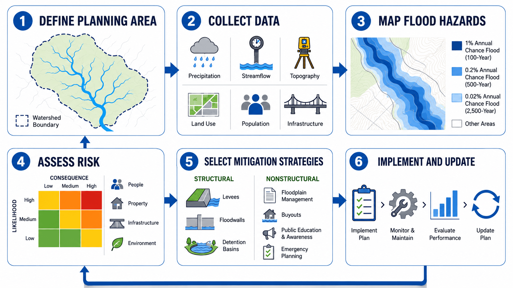
Notice that mitigation is not the first step. A detention basin, floodwall, road closure plan, culvert upgrade, or zoning change only makes sense after the flood source, exposed assets, consequences, and implementation path are understood.
What Is Flood Planning?
Flood planning is a structured approach for reducing flood risk across a site, neighborhood, watershed, or community. It identifies where flooding may occur, what assets are exposed, how vulnerable those assets are, and which actions can reduce damage, disruption, and safety risk.
A strong flood plan is more than a flood map. It should connect mapped flood hazards to practical decisions: where development should be limited, which roads need emergency access protection, which culverts or channels need upgrades, which properties may need floodproofing, and which natural systems should be preserved or restored.
Flood planning does not eliminate flooding. It reduces consequences by understanding how water moves, where people and infrastructure are exposed, and which mitigation actions create the best risk reduction for the site or community.
What a Flood Plan Should Include
A useful flood plan should be specific enough to guide decisions. It should define the flood problem, show who or what is at risk, compare multiple risk-reduction options, and explain how the selected actions will be implemented and maintained.
| Flood plan component | What it answers | Why it matters |
|---|---|---|
| Planning boundary | What site, neighborhood, watershed, drainage basin, or community area is included? | Prevents the plan from missing upstream runoff, downstream tailwater, or off-site access constraints. |
| Flood sources | Is flooding caused by river overflow, stormwater ponding, coastal surge, dam or levee failure, or multiple sources? | Different flood mechanisms require different data, models, warning times, and mitigation strategies. |
| Risk inventory | Who and what is exposed to floodwater? | Identifies homes, businesses, roads, utilities, schools, hospitals, emergency routes, and environmental assets at risk. |
| Mitigation alternatives | Which structural, nonstructural, green infrastructure, and emergency planning options are available? | Forces comparison before selecting a preferred action and reduces the chance of overbuilding the wrong solution. |
| Residual risk | What risk remains after the selected mitigation is implemented? | Helps communities understand that levees, basins, pumps, and floodwalls reduce risk but do not make an area flood-proof. |
| Implementation plan | Who will fund, permit, design, construct, operate, and update the plan? | Turns recommendations into accountable actions instead of leaving them as a report appendix. |
| Maintenance plan | Who keeps basins, culverts, pumps, channels, gates, and warning systems working? | Flood reduction systems often lose effectiveness when debris, sediment, vegetation, or mechanical issues are not managed. |
How Engineers Think About Flood Risk
Flood planning is usually risk-based. The question is not only, “Will water reach this location?” A better engineering question is, “What happens if floodwater reaches this location, how often could it happen, and what should be done about it?”
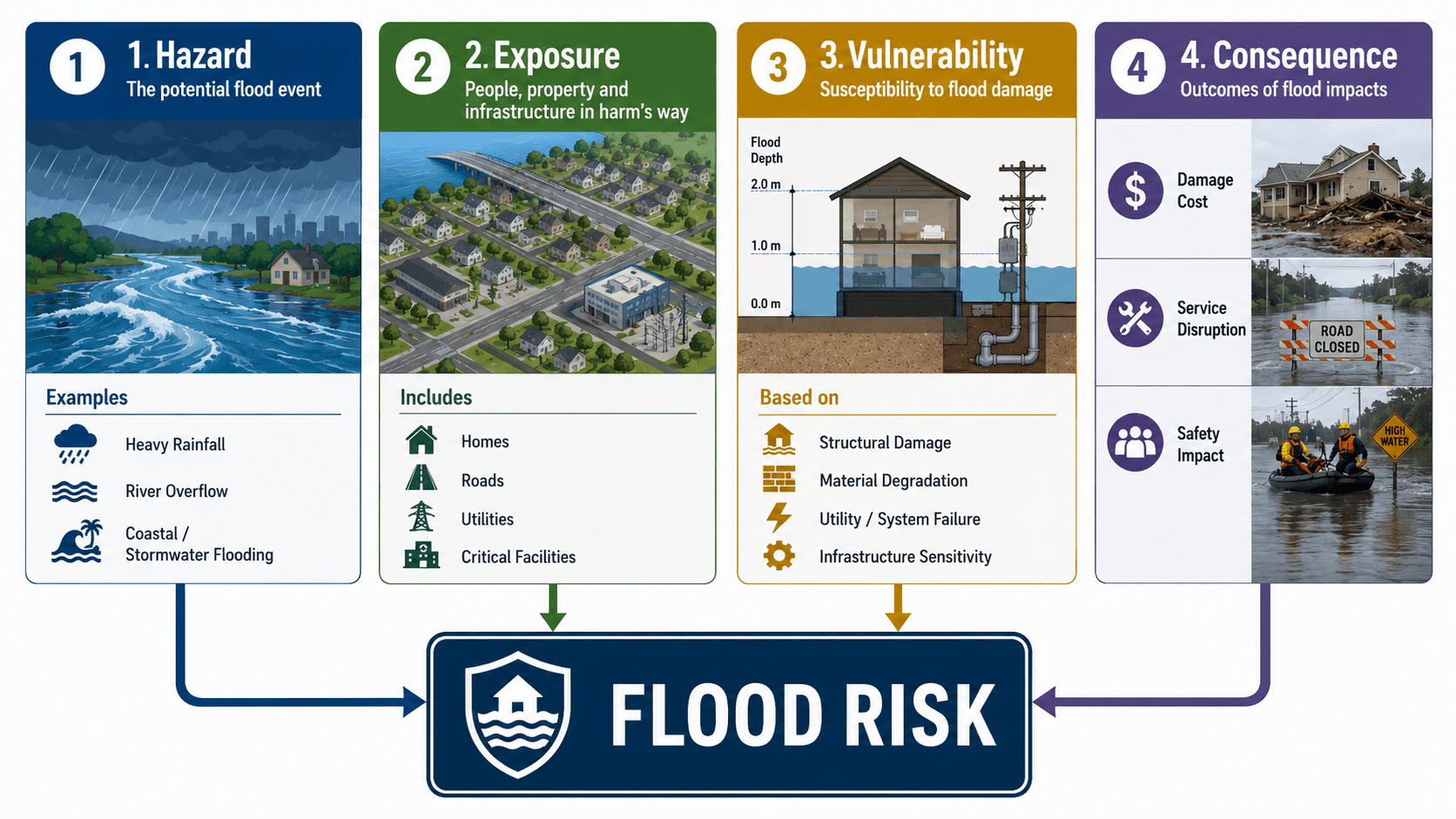
This expression is a planning concept, not a single universal design equation. It helps explain why two areas with the same flood depth can have very different risk. A shallow flood across an open field may have low consequence, while the same flood depth at a hospital, substation, school, or evacuation route can create major risk.
Hazard
The hazard describes the flood event itself: rainfall, river overflow, coastal surge, local stormwater flooding, dam or levee failure, snowmelt, or a combination of sources. Engineers look at depth, velocity, duration, timing, frequency, and warning time.
Exposure
Exposure identifies people, buildings, roads, utilities, emergency services, and environmental assets located where flooding can occur. A plan that ignores exposed infrastructure may underestimate disruption even if building damage is limited.
Vulnerability
Vulnerability explains how easily an exposed asset can be damaged. Finished floor elevation, foundation type, utility location, floodproofing, access routes, material durability, and maintenance condition all change vulnerability.
Consequence
Consequence measures what happens when flooding occurs. It includes property damage, safety risk, road closures, service outages, recovery time, environmental impacts, and economic disruption.
Types of Flood Planning
The term flood planning can refer to several related planning activities. The best approach depends on the flood source, scale of the problem, exposed assets, and decisions that need to be made.
| Type of flood planning | Primary focus | Common decisions |
|---|---|---|
| Floodplain planning | Managing development and land use in flood-prone areas. | Floodplain permits, open-space preservation, finished floor elevation, and development restrictions. |
| Stormwater flood planning | Reducing localized flooding from rainfall, inlets, storm drains, ditches, and urban runoff. | Pipe upgrades, inlet improvements, detention, green infrastructure, overland flow paths, and maintenance priorities. |
| Riverine flood planning | Understanding stream overflow, floodplain storage, bridge openings, levees, and channel conveyance. | Bridge and culvert improvements, floodplain restoration, levee review, channel improvements, and land-use controls. |
| Coastal flood planning | Managing surge, tides, wave effects, sea level change, evacuation, and shoreline exposure. | Setbacks, elevation, floodproofing, surge barriers, evacuation routes, and coastal resilience projects. |
| Emergency flood planning | Preparing for warning, response, road closures, evacuation, shelters, and recovery. | Emergency access routes, public warning systems, response thresholds, temporary closures, and communication plans. |
| Watershed flood planning | Evaluating how upstream runoff, storage, timing, and downstream controls interact across a drainage basin. | Regional detention, channel restoration, floodplain preservation, downstream impact checks, and capital project ranking. |
| Critical infrastructure flood planning | Protecting high-consequence facilities and service networks. | Substation protection, hospital access, pump station resilience, water facility protection, bridge access, and backup power review. |
Flood Planning vs Flood Mitigation vs Floodplain Management
These terms are related, but they are not the same. Flood planning is the broader decision process. Flood mitigation is the set of actions selected to reduce damage. Floodplain management is the policy and land-use side of managing development and activity in flood-prone areas.
| Term | What it means | Typical engineering or planning output |
|---|---|---|
| Flood planning | A coordinated process for identifying flood risk, evaluating alternatives, setting priorities, and updating the plan over time. | Planning maps, risk tables, mitigation priorities, project phasing, emergency access review, and maintenance responsibilities. |
| Flood mitigation | Actions used to reduce flood damage, disruption, or safety risk. | Detention basins, culvert upgrades, levees, floodwalls, buyouts, building elevation, green infrastructure, and warning systems. |
| Floodplain management | Policies, regulations, and development practices used to manage land in flood-prone areas. | Floodplain permits, zoning limits, minimum finished floor elevations, open-space preservation, and development review criteria. |
| Flood emergency planning | Preparedness and response actions used during or immediately before a flood event. | Evacuation routes, road closure plans, warning procedures, shelter planning, and emergency communication protocols. |
Key Data Needed for Flood Planning
Flood planning depends on data quality. A plan can look polished but still fail if the rainfall assumptions are outdated, the storm drain inventory is incomplete, the culvert capacity is unknown, or local flooding complaints are ignored.
| Flood planning input | Why it matters | Engineering implication |
|---|---|---|
| Rainfall and storm frequency | Controls runoff volume, peak flow, and how frequently flood conditions may occur. | Changes sizing, level of service, emergency planning assumptions, and future condition sensitivity. |
| Topography and ground elevations | Shows where water will collect, overtop roads, enter buildings, or flow toward low areas. | Supports floodplain mapping, finished floor review, emergency route checks, and overland flow analysis. |
| Watershed boundary and drainage area | Defines the land area contributing runoff to a stream, culvert, channel, or storm drain system. | A wrong boundary can underestimate peak flow or miss upstream development effects. |
| Land use and impervious cover | Urbanization increases runoff volume and reduces infiltration time. | May require detention, retention, storm drain upgrades, green infrastructure, or stricter development controls. |
| Culverts, storm drains, bridges, and channels | These features control conveyance, backwater, ponding, and overtopping locations. | Undersized, blocked, or damaged infrastructure can create flooding outside the mapped floodplain. |
| Historic flooding and local complaints | Field history often reveals problems that maps and models miss. | Helps identify recurring road closures, nuisance flooding, debris issues, and drainage bottlenecks. |
| Critical facilities and emergency routes | Hospitals, schools, substations, water facilities, and evacuation routes carry higher consequence. | Raises the priority of mitigation even where expected flood depth is moderate. |
Foundational topics such as hydrology and stormwater management help explain how rainfall becomes runoff and how urban drainage systems influence flood behavior.
Flood Planning Inputs and Outputs
A planning team should be able to trace each planning output back to specific data. If the plan recommends a culvert upgrade, detention basin, buyout area, emergency route, or zoning change, the supporting data should explain why that action is needed.
| Input | Planning output | Review question |
|---|---|---|
| Rainfall data | Design storm assumptions, runoff estimates, and sensitivity checks. | Are rainfall values current and appropriate for the planning horizon? |
| Topography | Flow paths, low points, overflow routes, and floodplain boundaries. | Does the terrain data show where water goes when pipes or channels exceed capacity? |
| Streamflow records | Frequency estimates, model calibration checks, and historical flood context. | Do observed events support or challenge the modeled flood behavior? |
| Drainage inventory | Culvert, bridge, channel, inlet, and storm drain constraints. | Are known bottlenecks and maintenance problems included? |
| Critical facilities | Priority areas for risk reduction and emergency access protection. | Which facilities create the highest consequence if flooded or isolated? |
| Historic flood reports | Local validation of model results and recurring problem area identification. | Does the plan explain known flooding that residents or public works teams have observed? |
| Land use and zoning | Future condition runoff assumptions and development controls. | Could future impervious cover make the current recommendation obsolete? |
| Maintenance records | Known weak points and asset reliability assumptions. | Could debris, sediment, vegetation, or pump failure reduce expected performance? |
Common Flood Planning Deliverables
A flood planning effort should produce outputs that decision-makers can use. Good deliverables make the flood problem visible, rank priorities, identify ownership, and give engineers a path toward design or implementation.
| Deliverable | What it contains | Who uses it |
|---|---|---|
| Flood hazard map | Inundation areas, flood depths, flood zones, flow paths, road overtopping areas, and warning locations. | Engineers, planners, emergency managers, public works teams, and local officials. |
| Risk inventory | Buildings, roads, utilities, critical facilities, vulnerable populations, environmental assets, and exposed infrastructure. | Communities, emergency managers, grant teams, public works staff, and planning departments. |
| Mitigation project list | Ranked structural, nonstructural, green infrastructure, and emergency planning actions. | Municipal staff, engineering teams, funding agencies, and capital improvement planners. |
| Emergency access map | Routes that must remain passable, alternate routes, closure points, and critical service connections. | Emergency management, fire departments, police, public works, and transportation agencies. |
| Maintenance responsibility matrix | Ownership and inspection responsibility for basins, culverts, channels, pumps, gates, and warning systems. | Owners, municipalities, public works teams, HOAs, site managers, and operations teams. |
| Implementation schedule | Phasing, funding strategy, permits, responsible parties, preliminary costs, and project dependencies. | Decision-makers, grant writers, capital planning teams, and engineering project managers. |
Common Flood Mitigation Strategies
Flood planning should compare more than one mitigation type. A structural project may reduce flood depth at a specific location, but nonstructural measures, emergency planning, land-use controls, and green infrastructure may reduce risk more effectively across a wider area.
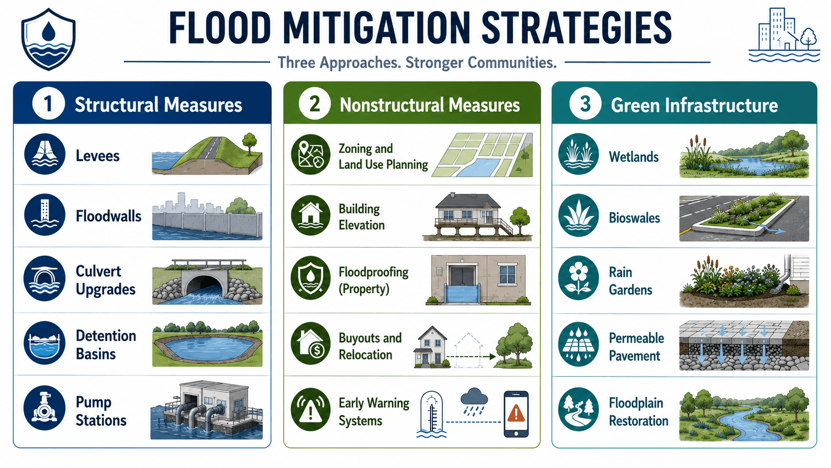
| Strategy type | Examples | Best use |
|---|---|---|
| Structural measures | Levees, floodwalls, detention basins, culvert upgrades, pump stations, channel improvements, bridge opening improvements. | Useful where a physical constraint or hydraulic bottleneck must be addressed, but may require permits, maintenance, and downstream impact review. |
| Nonstructural measures | Zoning, floodplain management, buyouts, building elevation, floodproofing, warning systems, public education, emergency route planning. | Useful when reducing exposure or vulnerability is more practical than trying to control all floodwater. |
| Green infrastructure | Wetlands, bioswales, rain gardens, permeable pavement, floodplain restoration, riparian buffers. | Useful for slowing runoff, adding storage, improving water quality, and supporting distributed flood reduction in urban or watershed planning. |
A larger pipe, channel, or pump station may move water away from one location faster, but it can increase downstream peak flow if storage, timing, and tailwater are not evaluated.
Residual Risk After Flood Mitigation
Residual risk is the flood risk that remains after mitigation is in place. This is one of the most important ideas in flood planning because no practical flood protection system removes all risk.
A levee can be overtopped, a floodwall can require closure operations, a pump station can lose power, a detention basin can lose storage to sediment, and a culvert can be blocked by debris during the storm. Flood planning should explain what happens if the design event is exceeded, a structure underperforms, or maintenance is not completed.
Structural protection can reduce flood frequency or depth, but it can also create false confidence if people assume the area is now flood-proof. Good planning keeps emergency access, warning, maintenance, and residual risk visible.
Site-Level, Community-Level, and Watershed-Level Planning
Flood planning changes depending on scale. A site plan may focus on finished floor elevations and emergency access, while a watershed plan may focus on hydrograph timing, storage, regional detention, and downstream impacts.
| Planning scale | Main question | Typical planning decisions |
|---|---|---|
| Site-level flood planning | Can this property be developed, accessed, and maintained without creating unacceptable flood risk? | Finished floor elevation, grading, detention, drainage easements, overland flow paths, culvert sizing, and floodproofing. |
| Neighborhood or community flood planning | Which people, properties, roads, and public facilities are most exposed to recurring or severe flooding? | Road closure routes, drainage upgrades, buyout priorities, warning systems, capital improvement phasing, and emergency access protection. |
| Watershed-level flood planning | How does runoff from upstream land, channels, storage areas, and downstream controls interact across the drainage system? | Regional detention, channel restoration, floodplain preservation, bridge and culvert improvement programs, and downstream impact evaluation. |
A complete water resources planning approach often connects local flood planning with flood management, flood risk assessment, and long-term capital planning.
Who Uses Flood Planning?
Flood planning is used by more than engineers. The engineering analysis must be clear enough for planners, emergency managers, public works teams, developers, and elected decision-makers to act on it.
| User | How they use flood planning | Decision they need to make |
|---|---|---|
| Water resources engineers | Evaluate hazards, drainage systems, mitigation alternatives, tailwater, storage, and downstream impacts. | Which technical solution reduces risk without creating new problems? |
| Municipal planners | Guide land use, floodplain policy, capital projects, and resilience priorities. | Where should development be limited, modified, or supported by infrastructure upgrades? |
| Emergency managers | Plan road closures, warning thresholds, evacuation, shelters, and critical facility access. | Which routes and services must remain functional during flood conditions? |
| Developers | Evaluate site feasibility, grading, detention, floodplain permitting, utilities, and access. | Can the site be developed without increasing risk on-site or downstream? |
| Public works teams | Maintain culverts, basins, channels, pumps, storm drains, and warning assets. | Which assets are most critical to inspect, clean, repair, or replace? |
Senior Engineer Flood Planning Review Checklist
A flood plan should be reviewed like an engineering decision document, not just a map package. The checklist below helps identify whether the plan has enough technical basis to support mitigation decisions.
Confirm the planning boundary, verify data sources, identify flood mechanisms, test risk assumptions, compare mitigation options, check downstream effects, assign maintenance responsibility, document residual risk, and update the plan when land use or rainfall assumptions change.
| Review check | What to look for | Why it matters |
|---|---|---|
| Planning boundary | Watershed, drainage basin, municipality, development site, or critical facility service area is clearly defined. | A boundary that is too small can miss upstream runoff, downstream tailwater, or emergency access impacts. |
| Flood sources | Riverine flooding, local stormwater flooding, coastal flooding, dam or levee failure, groundwater interaction, and overland flow are considered where relevant. | Different flood sources require different data, models, response times, and mitigation approaches. |
| Data quality | Rainfall, streamflow, terrain, land use, drainage infrastructure, and historic flood records are documented. | Mitigation decisions are only as reliable as the inputs used to define the flood problem. |
| Critical consequences | Hospitals, schools, power systems, water facilities, bridges, evacuation routes, and vulnerable populations are identified. | Moderate flood depths can still create high risk when the exposed asset is critical. |
| Mitigation alternatives | Structural, nonstructural, green infrastructure, emergency planning, and land-use options are compared. | A plan that jumps to one project too early may miss cheaper, more resilient, or less disruptive options. |
| Downstream impacts | Changes in discharge, timing, storage, tailwater, and overflow paths are checked beyond the project boundary. | A flood improvement at one site should not simply transfer the problem to another location. |
| Residual risk | The plan explains what risk remains after the proposed actions are implemented. | Decision-makers need to know what happens if a storm exceeds the design event or a system does not perform as expected. |
| Operations and maintenance | Responsible parties are assigned for culverts, channels, pumps, basins, gates, warning systems, and vegetation control. | Flood infrastructure often fails to perform because debris, sediment, vegetation, or mechanical issues are not managed. |
| Future conditions | Development, impervious cover, climate-adjusted rainfall, sea level where relevant, and long-term asset condition are considered. | A plan based only on existing conditions can become outdated before the mitigation project is built. |
Practical Flood Planning Example
Consider a proposed development near a stream crossing and an older residential neighborhood. A shallow review may only check whether the site is inside a mapped floodplain. A stronger flood planning review looks at how runoff, access, infrastructure, and downstream consequences interact.
| Planning step | Example decision | Engineering meaning |
|---|---|---|
| Define area | Review a 120-acre drainage area flowing toward an existing road culvert. | The development site alone is too small; upstream runoff and downstream conveyance control the problem. |
| Identify hazard | Document repeated road overtopping during intense rainfall. | The flood issue is not only mapped floodplain overflow; local stormwater capacity also matters. |
| Assess exposure | Identify 35 homes, one school access route, and a downstream sanitary lift station. | The plan should prioritize consequences, not just water depth. |
| Test mitigation | Compare culvert upgrade, upstream detention, preserved open space, and emergency route improvements. | Multiple solutions should be compared before selecting a capital project. |
| Check risk transfer | Confirm no increase in downstream peak flow, flood depth, or erosion risk. | A local improvement should not push the flood problem onto downstream properties. |
| Implement | Phase culvert cleaning, warning signage, detention retrofit, and capital project design. | The plan becomes useful when it defines responsibility, timing, and next steps. |
Engineering interpretation
The flood planning question is not only whether detention reduces the post-development peak discharge. The review should also ask whether the culvert can pass the design flow, whether tailwater reduces outlet capacity, whether the emergency route remains open, whether overflow paths are protected, and whether basin maintenance is assigned.
Local flooding complaints are often early warning signs. If residents report repeated ponding, road overtopping, or debris blockage, that field history should be checked against the model instead of dismissed because the area is outside a mapped floodplain.
Flood Planning for Future Conditions
Flood planning should not only describe today’s risk. It should also test whether the plan remains useful as rainfall data, development patterns, infrastructure condition, and community needs change.
- Future impervious cover: New pavement, rooftops, and compacted areas can increase runoff volume and reduce the time to peak flow.
- Updated rainfall intensity: Older rainfall assumptions may not represent current or future design conditions.
- Redevelopment: A built-out watershed can behave differently when parcels are redeveloped at higher density.
- Aging drainage infrastructure: Pipes, culverts, channels, bridges, pumps, and detention basins may lose capacity or reliability over time.
- Coastal or tidal effects: In coastal areas, surge, tides, and sea level can increase tailwater and reduce drainage outlet capacity.
- Emergency service growth: New schools, hospitals, utilities, and transportation corridors can change which assets are most critical.
Future-condition planning is where flood predictive modeling and scenario testing can become useful, especially when communities need to understand how risk changes over time.
Engineering Judgment and Field Reality
Flood planning is sensitive to assumptions that may not be obvious on a clean map. Debris can block culverts. Sediment can reduce channel capacity. A detention basin can lose storage if it is not maintained. A road that appears passable in a model may become unsafe if flow velocity, depth, or poor visibility is considered.
Experienced engineers look for hydraulic controls and weak links: undersized crossings, sharp channel transitions, backwater from downstream systems, high tailwater, narrow bridge openings, buried outfalls, shallow roadside ditches, and low emergency access points. These features often control real flood performance more than the general floodplain outline.
A flood plan that protects a building pad but leaves the only access road underwater may still fail the practical test. Flood planning should consider access, utilities, emergency services, and recovery time, not just finished floor elevation.
When Flood Planning Breaks Down
Flood planning breaks down when the plan looks technically complete but fails to represent how flooding actually occurs, how assets fail, or how mitigation will be implemented and maintained.
- Map-only planning: FEMA maps and local flood maps are useful, but they may not capture local drainage problems, future development, undersized storm drains, or culvert blockage.
- Tailwater ignored: Downstream water levels can reduce culvert, channel, and storm drain outlet capacity even when upstream conveyance appears adequate.
- Debris blockage ignored: Trash racks, culverts, bridge openings, and inlets can lose capacity during the exact storm when they are needed most.
- No overflow route: Water will find a path when the pipe or channel system is full; if that route crosses buildings or critical roads, risk may be underestimated.
- No residual risk discussion: Levees, pumps, basins, and floodwalls reduce risk but do not remove it.
- Disconnected emergency planning: Engineering mitigation is weaker when it is not tied to road closures, warning thresholds, evacuation, and response procedures.
- No downstream review: Conveyance improvements can shift flood peaks downstream if storage, timing, and tailwater are not evaluated.
- No maintenance path: Basins, culverts, pumps, gates, and channels require maintenance to perform as planned.
Common Flood Planning Mistakes and Practical Checks
The most common flood planning mistakes come from oversimplifying the problem. Flood risk is rarely controlled by one map, one pipe, one basin, or one storm event.
| Mistake | Why it creates risk | Practical check |
|---|---|---|
| Assuming “outside the floodplain” means “no flood risk” | Urban stormwater flooding, blocked inlets, culvert backwater, and shallow overland flow can occur outside mapped floodplains. | Review drainage complaints, local low points, inlet capacity, overland flow paths, and road overtopping history. |
| Choosing a mitigation project before defining the problem | A detention basin, floodwall, or culvert upgrade may not solve the controlling issue. | Identify the flood source, hydraulic control, exposed assets, and consequence before selecting a solution. |
| Ignoring emergency access | A site can avoid building damage but still become unsafe if evacuation or emergency response routes are flooded. | Check road overtopping depth, duration, velocity, alternate routes, and critical service access. |
| Not assigning maintenance responsibility | Flood reduction infrastructure can lose capacity due to debris, sediment, vegetation, vandalism, or mechanical failure. | Assign inspection frequency, responsible party, cleanout triggers, and long-term funding. |
| Ignoring future conditions | Development and changing rainfall patterns can increase runoff after the plan is complete. | Evaluate future impervious cover, redevelopment, rainfall sensitivity, sea level where relevant, and infrastructure aging. |
A good flood planning review should answer four questions: Where does the water come from, where does it go, who or what is affected, and who is responsible for keeping the chosen solution working?
Relevant Manuals, Data Sources, and Design References
Flood planning may draw from FEMA flood mapping, local hazard mitigation plans, state flood planning programs, stormwater design manuals, floodplain ordinances, and project-specific drainage criteria. These references do not replace engineering judgment; they provide the planning and regulatory context for risk-based decisions.
- FEMA Local Mitigation Planning Handbook: FEMA Local Mitigation Planning Handbook provides a practical framework for local governments and planning teams developing or updating hazard mitigation plans, including risk assessment, mitigation actions, implementation, and plan maintenance.
- Project-specific criteria: Local floodplain ordinances, stormwater manuals, drainage criteria, transportation agency requirements, and owner standards may control final planning decisions.
- Engineering use: Use references to support assumptions, but verify them against site-specific topography, infrastructure condition, observed flooding, maintenance constraints, and future development.
Frequently Asked Questions
Flood planning is the process of identifying flood hazards, evaluating who and what is exposed, estimating likely consequences, and selecting actions that reduce flood damage before a storm occurs. In water resources engineering, it connects mapping, hydrology, hydraulics, land use, infrastructure design, emergency access, and long-term maintenance.
A flood plan should include the planning boundary, flood sources, flood hazard maps, exposed assets, vulnerability and consequence review, mitigation alternatives, implementation priorities, emergency access considerations, maintenance responsibilities, and an update process for future conditions.
The main flood planning steps are defining the planning area, collecting data, mapping flood hazards, assessing risk, selecting mitigation strategies, implementing projects, maintaining assets, and updating the plan as conditions change. A strong plan also identifies ownership, funding, downstream impacts, and future development assumptions.
Flood planning is the overall decision process used to understand risk and choose actions. Flood mitigation is the set of actions that come from that process, such as detention basins, culvert upgrades, floodwalls, zoning, building elevation, buyouts, green infrastructure, and warning systems.
Flood maps are useful starting points, but they may not capture local drainage complaints, blocked culverts, updated rainfall data, future development, tailwater, undersized storm drains, or flooding outside mapped riverine floodplains. Engineers use flood maps with site data, modeling, field observations, and judgment.
Summary and Next Steps
Flood planning turns flood risk into a practical decision process. It defines the planning area, identifies flood hazards, evaluates exposure and vulnerability, compares mitigation strategies, documents residual risk, and creates a path for implementation and updates.
The strongest flood plans combine engineering analysis with field judgment. They look beyond flood maps, consider drainage infrastructure and emergency access, compare structural and nonstructural options, check downstream impacts, account for future conditions, and assign maintenance responsibility.
Where to go next
Continue your learning path with related Turn2Engineering water resources topics.
-
Flood Risk Assessment
Learn how flood hazard, exposure, vulnerability, and consequence are evaluated in more detail.
-
Flood Mitigation Projects
Explore how planning recommendations become physical projects, policy actions, and resilience improvements.
-
Flood Predictive Modeling
See how modeling and forecasting can support flood planning, warning, and decision-making.