Key Takeaways
- Core idea: Water resources engineering is the civil engineering field that plans, models, designs, and manages water systems.
- Engineering use: It supports water supply, stormwater drainage, flood protection, groundwater management, water quality, and watershed planning.
- What controls it: Rainfall, runoff, land use, soil, topography, storage, hydraulics, water quality, demand, and regulatory criteria shape most decisions.
- Practical check: Good water resources work is not just calculation; it depends on field data, boundary conditions, maintenance, uncertainty, and downstream impacts.
Table of Contents
Introduction
Water resources engineering is a branch of civil engineering focused on planning, designing, modeling, and managing systems that control water. It includes water supply, stormwater drainage, flood protection, groundwater, water quality, dams, reservoirs, rivers, channels, pipes, and watershed systems so communities can use water safely while reducing risk to people and the environment.
Water resources engineering is the civil engineering discipline that plans, models, designs, and manages water systems. It focuses on water supply, stormwater drainage, flood protection, groundwater, water quality, wastewater, and resilient infrastructure so communities can safely control, use, store, and protect water.
Water Resources Engineering Diagram
Notice that the field is not only about one type of infrastructure. It connects natural watershed behavior with engineered systems that store, move, treat, distribute, and control water.
What is Water Resources Engineering?
Water resources engineering is the applied engineering discipline that manages water quantity, water quality, and water-related risk. It deals with where water comes from, how it moves, how much is available, how it should be stored or conveyed, how it affects people and infrastructure, and how it should be protected for long-term use.
In a civil engineering context, water resources engineering sits between natural science and built infrastructure. Engineers study rainfall, watersheds, rivers, aquifers, floodplains, and ecosystems, then apply that understanding to systems such as culverts, channels, reservoirs, storm sewers, detention basins, pumps, treatment facilities, levees, wells, and distribution networks.
A useful way to understand the field is to think of three problems: too little water, too much water, and water that is not clean enough for its intended use. Water resources engineers work across all three.
| Water problem | Engineering focus | Typical examples |
|---|---|---|
| Too little water | Water supply, storage, demand planning, reuse, and groundwater management | Reservoir planning, wells, treatment plants, storage tanks, reclaimed water systems, drought planning |
| Too much water | Stormwater, drainage, flood control, conveyance, and floodplain management | Culverts, channels, detention ponds, levees, flood studies, bridge hydraulics, storm sewer networks |
| Poor water quality | Treatment, monitoring, pollution control, erosion control, and watershed protection | Water quality sampling, sediment control, pollutant reduction, wastewater treatment, green infrastructure |
How Natural Water Becomes an Engineered System
Water resources engineering starts with the natural water cycle. Rainfall becomes runoff, infiltration, streamflow, groundwater recharge, storage, evaporation, and eventually downstream flow. The engineering challenge is that natural water movement rarely matches human needs exactly. Water may arrive too quickly, too slowly, in the wrong place, or with pollutants attached to it.
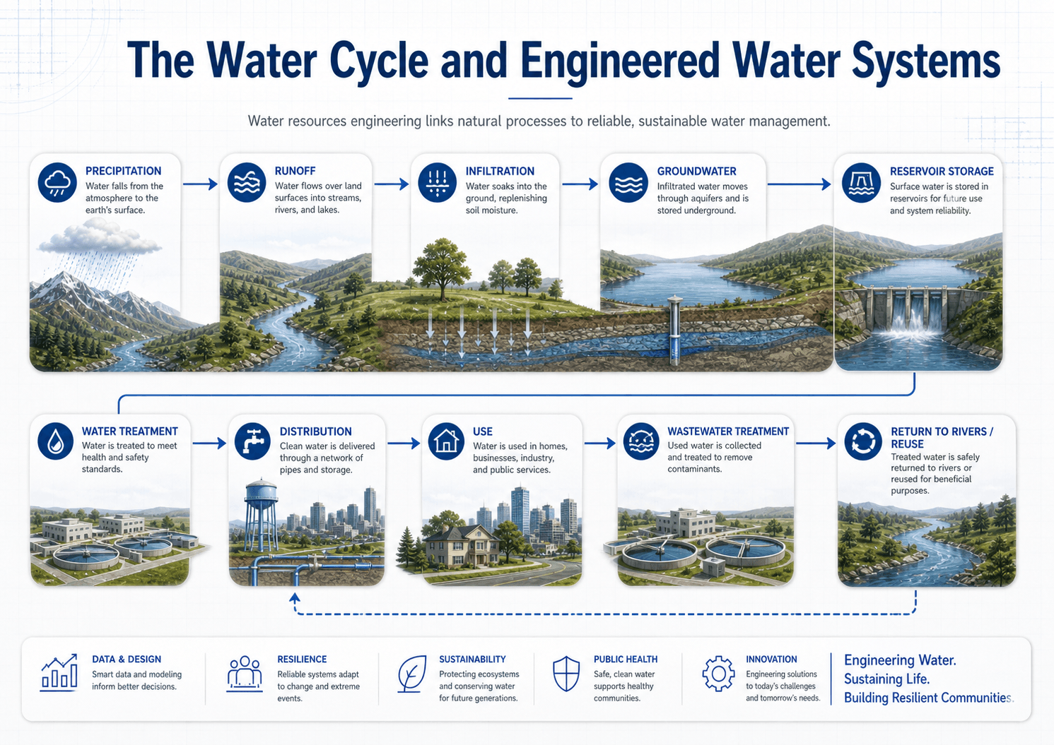
Hydrology estimates how much water is available
Hydrology helps engineers estimate rainfall, runoff, infiltration, streamflow, groundwater recharge, and watershed response. It is the foundation for flood studies, reservoir planning, stormwater design, and long-term water supply planning.
Hydraulics determines how water moves
Hydraulics focuses on flow depth, velocity, pressure, energy losses, and conveyance through rivers, channels, culverts, pipes, spillways, and control structures. Hydrology may estimate the amount of water; hydraulics determines whether a system can safely carry it.
Infrastructure changes timing, storage, and risk
Dams, reservoirs, detention ponds, storm drains, channels, pumps, wells, and treatment facilities do more than move water. They change when water arrives, where it is stored, how fast it flows, whether pollutants settle or remain suspended, and who is exposed to risk downstream.
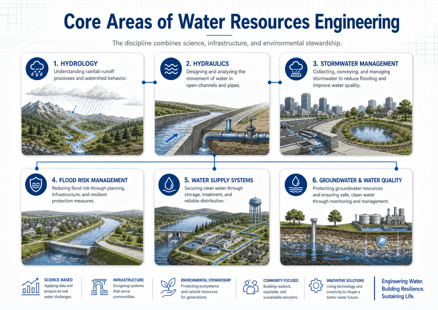
Core Areas of Water Resources Engineering
The field is broad because water touches many parts of civil infrastructure. A single project may involve watershed hydrology, hydraulic design, floodplain review, water quality protection, groundwater assumptions, and maintenance planning at the same time.
- Hydrology: rainfall, runoff, infiltration, watershed response, streamflow, storage, and drought behavior.
- Hydraulics: flow in open channels, rivers, storm drains, culverts, pipes, spillways, and hydraulic structures.
- Stormwater management: drainage, runoff reduction, detention, retention, water quality treatment, and urban flood control.
- Flood risk management: floodplains, levees, floodwalls, storage, bridge openings, warning systems, and resilient planning.
- Water supply systems: reservoirs, wells, treatment, pumping, storage, distribution, demand forecasting, and drought resilience.
- Groundwater management: aquifers, recharge, drawdown, sustainable yield, well placement, contamination risk, and monitoring.
- Water quality: sediment, nutrients, bacteria, metals, dissolved oxygen, treatment trains, sampling, and pollutant control.
- Reuse and wastewater: collection, treatment, discharge, reclaimed water, beneficial reuse, and protection of receiving waters.
If a water project only considers peak flow, it is probably incomplete. Engineers also need to review volume, timing, tailwater, sediment, pollutant loading, maintenance access, downstream impacts, and what happens when a storm exceeds the design event.
What Do Water Resources Engineers Do?
Water resources engineers turn uncertain natural conditions into practical design decisions. Their work often begins with data collection and modeling, then moves into alternatives analysis, design, permitting, construction support, and long-term operation or maintenance review.
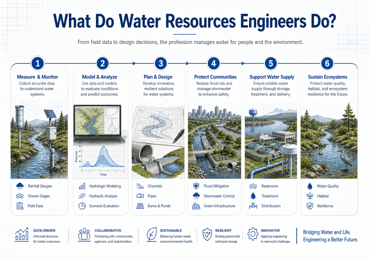
- Measure and monitor: collect rainfall, streamflow, groundwater, survey, water quality, and infrastructure data.
- Model and analyze: estimate runoff, flood peaks, water levels, flow velocities, storage needs, and system performance.
- Plan and design: develop channels, pipes, culverts, ponds, reservoirs, wells, pumps, treatment systems, and green infrastructure.
- Review risk: evaluate flooding, erosion, overtopping, water shortages, contamination, downstream impacts, and system failure modes.
- Coordinate requirements: work with owners, regulators, municipalities, utilities, environmental teams, surveyors, and contractors.
Is Water Resources Engineering a Good Career Path?
Water resources engineering can be a strong civil engineering career path for people who like infrastructure, environmental systems, field data, maps, modeling, public safety, and practical problem solving. The work is useful because nearly every community needs drainage, flood protection, water supply, water quality protection, and resilient infrastructure.
The career also has broad project variety. One engineer may work on a subdivision drainage study, while another may model a river floodplain, design a detention basin, review a culvert replacement, evaluate water supply reliability, or help a city update stormwater standards.
| Career area | Typical work | Common employers |
|---|---|---|
| Stormwater and drainage | Storm sewer design, detention ponds, runoff analysis, grading support, and development review. | Consulting firms, cities, counties, developers, and transportation agencies. |
| Floodplain and river engineering | Flood studies, hydraulic modeling, bridge openings, levees, channel improvements, and risk mapping. | Consultants, flood control districts, state agencies, federal agencies, and municipalities. |
| Water supply and utilities | Reservoir planning, wells, pumping, treatment coordination, storage, distribution, and demand forecasting. | Utilities, water authorities, municipalities, consulting firms, and public works departments. |
| Water quality and watershed protection | Pollutant control, sediment reduction, erosion control, green infrastructure, monitoring, and restoration. | Environmental agencies, watershed groups, municipalities, consultants, and infrastructure owners. |
Skills that help in water resources engineering
- Technical fundamentals: hydrology, hydraulics, statistics, fluid mechanics, open-channel flow, groundwater, and water quality basics.
- Modeling and software: GIS, CAD, hydrologic models, hydraulic models, stormwater models, spreadsheets, and design documentation.
- Field judgment: reading drainage patterns, identifying high-water marks, checking outfalls, understanding maintenance issues, and comparing models to real conditions.
- Communication: explaining flood risk, design assumptions, regulatory requirements, uncertainty, and alternatives to owners, reviewers, contractors, and the public.
Water resources engineering is a good fit if you enjoy combining calculations with real-world site conditions. The best engineers do not only run models; they question assumptions, verify field conditions, and explain water risk clearly.
Examples of Water Resources Engineering Projects
Water resources engineering becomes easier to understand when it is tied to real projects. These examples show how the same core ideas — rainfall, runoff, storage, flow, water quality, risk, and maintenance — appear in different types of civil engineering work.
| Project type | Primary engineering question | Typical design checks |
|---|---|---|
| Detention basin design | How can a site reduce peak discharge after development? | Runoff volume, outlet sizing, drawdown, emergency overflow, sediment storage, and maintenance access. |
| Floodplain study | How high will floodwater rise for a selected event? | Watershed flow, channel geometry, bridge losses, roughness, floodway limits, and mapped flood elevations. |
| Storm sewer upgrade | Can the pipe network carry runoff without unacceptable ponding or surcharge? | Inlet capacity, pipe slope, hydraulic grade line, tailwater, junction losses, and overland relief paths. |
| Culvert or bridge hydraulic analysis | Can water pass under a road safely during high flows? | Headwater, tailwater, velocity, scour risk, debris blockage, roadway overtopping, and downstream impacts. |
| Groundwater recharge project | Can stormwater or treated water safely infiltrate into the subsurface? | Soil infiltration, groundwater depth, mounding, water quality, clogging, pretreatment, and long-term monitoring. |
| Water reuse system | How can treated water be reused instead of discharged or wasted? | Demand, storage, treatment level, seasonal variation, public health requirements, and distribution reliability. |
What Controls Water Resources Engineering Decisions?
Water resources decisions are controlled by both physical conditions and project requirements. A design that works in one watershed may fail in another because the rainfall pattern, soils, slopes, land cover, tailwater, downstream channel, groundwater level, or maintenance reality is different.
| Factor | Why it matters | Engineering implication |
|---|---|---|
| Rainfall and design storm | Controls runoff volume, peak flow, flood levels, drainage capacity, and detention sizing. | Engineers must use appropriate rainfall depth, intensity, duration, frequency, and temporal distribution. |
| Watershed area and land use | Impervious surfaces, slopes, vegetation, and drainage paths control how quickly runoff forms. | Urbanized areas usually produce faster peaks, higher runoff, and greater water quality concern. |
| Soils and infiltration | Soil type affects infiltration, recharge, runoff volume, basin drawdown, and groundwater response. | Field soil conditions can determine whether infiltration practices are appropriate or risky. |
| Tailwater and downstream conditions | High downstream water levels can reduce pipe, culvert, and channel capacity. | A system that works under free outfall conditions may surcharge or backwater under real flood conditions. |
| Water quality targets | Sediment, nutrients, bacteria, metals, temperature, and dissolved oxygen affect receiving waters. | Projects may need pretreatment, filtration, settling, source control, or treatment train logic. |
| Maintenance and access | Clogged inlets, sediment-filled ponds, blocked culverts, and failed pumps can reduce capacity. | Designs must be maintainable, inspectable, and realistic for the owner’s operations team. |
Common Methods and Equations Used in Water Resources Engineering
Water resources engineers use equations and models to estimate flow, storage, water level, velocity, groundwater movement, and pollutant behavior. The specific method depends on the problem scale, data quality, design criteria, and level of risk.
The continuity equation states that flow rate equals flow area times velocity. It is one of the simplest ideas in water resources engineering, but it appears everywhere: pipes, channels, culverts, rivers, treatment units, and distribution systems.
Manning’s equation is commonly used for open-channel flow in rivers, ditches, canals, and stormwater channels. It relates flow to channel area, hydraulic radius, slope, and roughness. The result is only as good as the assumed roughness, geometry, slope, and boundary conditions.
- Q Flow rate, commonly expressed as cubic feet per second, gallons per minute, or cubic meters per second.
- A Flow area, such as the wetted area of a channel, pipe, culvert, or treatment unit.
- V Average velocity, which affects erosion, sediment movement, hydraulic losses, and safety.
- n Manning roughness coefficient, which represents resistance from channel material, vegetation, irregularity, and obstructions.
Other common tools include the Rational Method for small drainage areas, unit hydrographs for watershed response, flood frequency analysis, hydraulic grade line review, groundwater flow concepts such as Darcy’s law, and water quality mass-balance or treatment calculations.
Common Software and Data Sources
Water resources engineers often combine public data, field observations, survey information, GIS mapping, hydrologic models, hydraulic models, spreadsheets, and design drawings. Software does not replace engineering judgment, but it helps organize complex watersheds, storm events, drainage networks, and flood behavior.
| Tool or data type | What it helps with | Practical caution |
|---|---|---|
| GIS mapping | Watershed boundaries, land use, soils, contours, floodplains, and infrastructure mapping. | Map layers can be outdated, generalized, or inconsistent with field conditions. |
| Hydrologic models | Rainfall-runoff response, hydrographs, detention routing, peak flows, and watershed storage. | Results depend heavily on rainfall assumptions, loss methods, routing, and basin delineation. |
| Hydraulic models | Water surface elevation, flow depth, velocity, bridge impacts, culvert behavior, and floodplain limits. | Roughness, geometry, ineffective flow, boundary conditions, and calibration can control the answer. |
| Stormwater models | Urban drainage networks, inlets, pipes, storage, surcharge, overland flow, and water quality controls. | Small errors in inlet assumptions or downstream tailwater can create misleading results. |
| CAD and design plans | Grading, pipes, channels, culverts, profiles, structures, details, and construction documentation. | Drawings must match the model assumptions, survey control, and actual constructability. |
Water Resources Project Review Checklist
A strong water resources review asks more than “does the calculation work?” Engineers need to confirm that the watershed, data, assumptions, boundary conditions, design criteria, and field conditions support the conclusion.
Define the water problem, map the watershed and infrastructure, collect rainfall and flow data, choose an analysis method, model existing conditions, test proposed conditions, check downstream impacts, review water quality and maintenance, then verify the result against field conditions and project criteria.
| Check or decision | What to look for | Why it matters |
|---|---|---|
| Watershed boundary | Confirm divides, drainage paths, bypass flow, off-site inflow, and storm sewer connections. | A small watershed mapping error can change runoff volume, peak flow, and detention requirements. |
| Design storm selection | Check local criteria for rainfall depth, duration, frequency, temporal pattern, and climate assumptions. | Using the wrong storm can understate flood risk or oversize infrastructure unnecessarily. |
| Existing versus proposed conditions | Compare impervious cover, slopes, drainage time, storage, conveyance, and downstream discharge. | Development often increases runoff speed and volume unless storage or infiltration is added. |
| Tailwater and backwater | Review downstream water levels, receiving channel conditions, culvert submergence, and surcharge risk. | Outlet conditions often control real performance more than the upstream calculation suggests. |
| Water quality treatment | Identify pollutants of concern, treatment volume, sediment storage, pretreatment, and maintenance access. | A basin that controls peak flow may still fail to protect water quality if treatment logic is ignored. |
| Failure and exceedance path | Check where water goes if inlets clog, pumps fail, a basin overtops, or a larger storm occurs. | Safe overflow paths reduce damage when a system performs beyond its normal design range. |
Water Resources Engineering vs. Related Fields
Water resources engineering overlaps with several disciplines, which is why the term can be confusing. The difference is usually not the water itself, but the question being asked and the type of decision being made.
| Field | Main question | How it connects to water resources engineering |
|---|---|---|
| Hydrology | Where does water go, and how much water is moving through the watershed? | Provides rainfall, runoff, streamflow, recharge, and storage estimates for design and planning. |
| Hydraulic engineering | How does water flow through channels, rivers, pipes, culverts, and structures? | Determines flow depth, velocity, pressure, energy loss, capacity, erosion potential, and flood levels. |
| Environmental engineering | How can human and ecological health be protected from pollution and treatment failures? | Overlaps through water quality, treatment, wastewater, contaminant transport, and receiving water protection. |
| Urban planning | How should communities grow while managing risk, infrastructure, land use, and resilience? | Uses water resources analysis for floodplain planning, drainage corridors, green infrastructure, and development criteria. |
Engineering Judgment and Field Reality
Water resources work is filled with uncertainty. Rainfall records are limited, watersheds change over time, field conditions are not always shown on plans, and infrastructure performance depends on construction quality and maintenance. A clean model can still be wrong if the watershed boundary, outlet condition, roughness, infiltration assumption, or downstream constraint is wrong.
The most important water resources judgment is often deciding whether the model represents the real system. Experienced engineers compare calculations with field observations, historic flooding, channel condition, sediment evidence, inlet capacity, maintenance records, and downstream complaints before trusting a result.
Field reality also affects public expectations. A detention pond may reduce peak discharge for a selected design storm but still hold standing water after sedimentation. A culvert may pass the design flow but clog with debris. A storm sewer may be adequate on paper but surcharge when the downstream channel is high. A water supply system may meet average demand but struggle during drought, fire flow, or peak seasonal use.
When This Breaks Down
Simplified explanations of water resources engineering break down when a project is controlled by uncertainty, boundary conditions, or consequences rather than the main calculation. The more risk a project carries, the more engineers must test assumptions and evaluate failure behavior.
- Extreme events exceed the design storm: systems designed for a selected storm may still flood during larger or longer events.
- Downstream conditions control performance: high tailwater, sediment, vegetation, or blockage can reduce capacity even when upstream calculations appear adequate.
- Land use changes after design: added impervious area, grading changes, or upstream development can increase runoff and overwhelm older infrastructure.
- Water quality is treated as an afterthought: controlling peak flow does not automatically remove sediment, nutrients, bacteria, metals, or temperature impacts.
- Maintenance is ignored: inlets, culverts, ponds, pumps, filters, and vegetation systems need access, inspection, sediment removal, and long-term ownership.
Common Mistakes and Practical Checks
Beginners often think water resources engineering is mainly about choosing the right formula. In practice, the formula is only one part of the decision. The site, data, assumptions, system limits, and consequences matter just as much.
- Confusing hydrology with hydraulics: hydrology estimates the amount and timing of water, while hydraulics evaluates how that water moves through a system.
- Ignoring storage volume: peak flow reduction may fail if the total runoff volume and basin drawdown are not checked.
- Assuming clean outfalls: debris, sediment, vegetation, ice, or high receiving water levels can change real capacity.
- Overlooking groundwater: high groundwater can affect basin infiltration, utility trenches, foundations, dewatering, and contamination movement.
- Treating water quality as separate from drainage: stormwater systems often need to manage pollutants, not just move water away quickly.
Do not assume the modeled peak flow is the whole story. For many projects, the controlling issue is timing, tailwater, erosion, pollutant load, sediment storage, maintenance access, emergency overflow, or what happens downstream.
Useful References and Design Context
Water resources engineering uses local criteria, public data, design manuals, engineering judgment, and project-specific requirements. No single reference controls every project, but professional water resources organizations and public agencies help define accepted practice, terminology, research, and technical direction.
- ASCE Environmental & Water Resources Institute: ASCE Environmental & Water Resources Institute provides professional resources and technical focus areas for environmental and water-related engineering issues.
- USGS water science and data: USGS Water Resources provides public water data, water science resources, streamflow information, groundwater information, and national water research context.
- EPA stormwater and water quality context: EPA NPDES Stormwater Program provides regulatory and educational context for stormwater pollution control, permits, runoff, and water quality protection.
- Project-specific criteria: local stormwater manuals, floodplain ordinances, utility standards, owner requirements, state agency criteria, and authority-having-jurisdiction requirements may control final design.
- Engineering use: engineers combine public rainfall data, stream gage records, survey information, hydraulic models, water quality criteria, field observations, and design standards to make defensible project decisions.
Frequently Asked Questions
Yes. Water resources engineering is a major branch of civil engineering focused on water movement, storage, supply, drainage, flood risk, groundwater, water quality, and related infrastructure. It often overlaps with environmental engineering, but its core work is the planning, analysis, design, and management of water systems.
A water resources engineer studies water systems, develops models, estimates flows, designs infrastructure, reviews flood risk, plans water supply systems, evaluates stormwater controls, and protects water quality. Their work may include culverts, channels, detention ponds, reservoirs, wells, treatment facilities, flood studies, and watershed plans.
Hydrology studies how water moves through the natural environment, including rainfall, runoff, infiltration, streamflow, and groundwater recharge. Water resources engineering uses hydrology along with hydraulics, infrastructure design, modeling, water quality, planning, and field judgment to solve practical water problems.
Water resources engineering is important because communities need reliable water supply, safe drainage, flood protection, clean waterways, sustainable groundwater use, and resilient infrastructure. Without it, cities, farms, roads, utilities, ecosystems, and public health are more vulnerable to drought, flooding, pollution, erosion, and infrastructure failure.
Water resources engineering can be a strong career path for people interested in civil infrastructure, flooding, water supply, environmental protection, modeling, field data, and community resilience. Common employers include consulting firms, municipalities, utilities, state agencies, flood control districts, and environmental organizations.
Common tools include GIS software, hydrologic models, hydraulic models, stormwater models, spreadsheets, CAD tools, survey data, and agency rainfall or streamflow databases. Examples may include HEC-HMS, HEC-RAS, SWMM, Civil 3D, ArcGIS, QGIS, and local design spreadsheets depending on the project.
Summary and Next Steps
Water resources engineering is the civil engineering discipline that connects natural water movement with practical infrastructure, public safety, water supply, flood control, groundwater protection, and environmental stewardship. It helps communities manage water when there is too much, too little, or when quality must be protected.
The strongest water resources decisions combine hydrology, hydraulics, field data, modeling, design criteria, maintenance reality, and downstream impact review. A good design does not only pass a calculation; it performs under real site conditions and gives water a safe, maintainable path through the system.
Where to go next
Continue your learning path with related Turn2Engineering resources.
-
Hydrology
Learn how rainfall, runoff, infiltration, streamflow, groundwater recharge, and watershed response form the foundation of water resources engineering.
-
Hydrologic Cycle
Review how precipitation, runoff, infiltration, groundwater, storage, evaporation, and streamflow connect across natural and engineered systems.
-
Stormwater Management
See how engineers manage runoff, drainage, detention, flooding, and water quality in developed areas.
-
Water Resources Modeling
Explore how engineers use models to simulate watersheds, rivers, stormwater systems, groundwater, storage, and flood scenarios.